Background
If you find this free trail guide useful, please provide payment by picking up at least one piece of litter on your hike. Cha-ching! Thanks for being awesome! (And here’s a quick primer on Leave No Trace, too, to help us keep the trails nice and fresh for each other.)
Background you can feel free to skip: Initially, I’d shoehorned two distinct Alander Mountain hikes onto one page, but the result was a monster that raged out of control, consuming entire reams of printer paper. Both hikes lead to the same destination, but approach from opposite sides of the mountain. This page details the gentler, 8-mile up-and-back hike (which is gentler because the trailhead is 700 feet higher). If you want to do the steep, 5.4-mile loop, check out the original Alander Mountain write-up. The rest of the “Background you can feel free to skip” below is taken directly from that page.
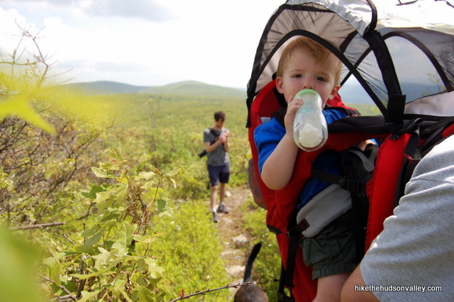
There are several good ways to get to the top of Alander Mountain, but there aren’t any easy ones. Of the two ways I’ve tried, the first is the longest hike (8 miles) I’ve ever done with a baby on my back, and the other is the steepest (1,822 feet in ascent in 5.4 miles). My son Evan approved of them both, and hopefully he’ll still like this hike when he has to do some of the walking himself.

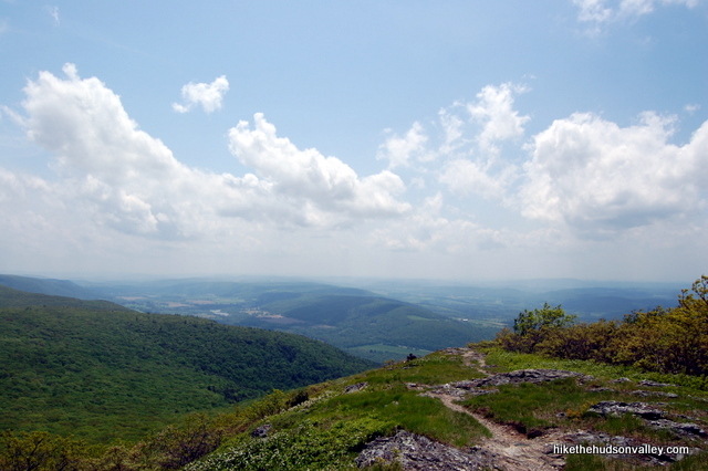
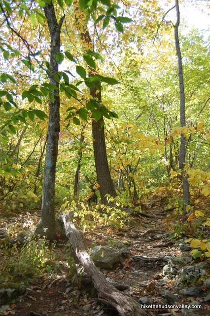
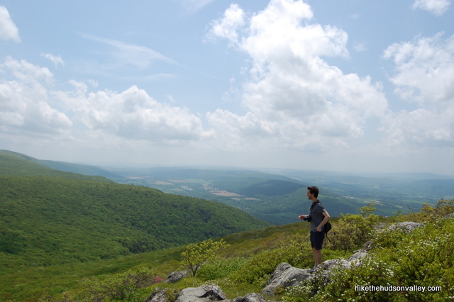
The summit of Alander Mountain is unique for this area in that there’s no one place you can point to and say, “This is the best spot to take in the view.” The grass, rocks and low bushes along the trail at the summit allow you to stop wherever you’d like, grab a seat and create your own personal money spot.
For all the beauty you’ll find here, you won’t be bothered by crowds, unless perhaps you’re competing for a spot in the cabin near the summit. Actually, that’s been empty both times I’ve been up here, so maybe crowds aren’t an issue there, either.
On the sunny spring day when I was here last, there were a few people lazing about near the summit, but not nearly as many as there should have been. This is a gorgeous hike that should be high on your to-do list if you’re willing to burn a few (thousand) calories to earn some awesome views.
One more minor detail: If I was hoping to come across an eastern timber rattlesnake in its natural environment, this is the hike I would pick. I haven’t seen one here in my visits, but I am apparently in the minority. They are very common in the Taconic Range, and at Mt. Alander in particular. Step carefully out there!
**UPDATE February 24, 2014** The Massachusetts Dept of Conservation and Recreation has a very nice (revamped, I’m almost 100% sure) Mt. Washington State Forest homepage, complete with a contact number and with a very nice PDF trail map that charts this entire hike. Thanks, MassParks!
Trail Guide
Bonus unsolicited advice: Don't depend on having cell service in the woods - it can be spotty out there! Download this trail guide to your phone before you head out. (It's easy to do on iPhone and Android.) May your connection to nature be strong, even when your connection to the internet is weak.
1. From the parking area, head over to the kiosk and pick up a trail map. You’ll be following the blue-blazed Alander Mountain Trail all the way up. Head past the kiosk, on the trail across the field, to begin your adventure.
2. Just keep chugging along, crossing over streams (sometimes over some funky wooden bridges) and gently climbing. You’ll see the well-marked Charcoal Pit and Ashley Hill trails joining you from the left. Just ignore them and keep on going.
3. The trail rolls along, gradually becoming an uphill-only affair.
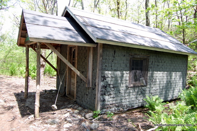
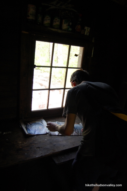
4. After 3.5 miles, you’ll come to a cabin on your left. From what I can tell, this place is first-come, first-served, and free. Since there’s no camping allowed up here otherwise, the wooden bunks in this cabin look like the only option for sleeping on Alander Mountain.
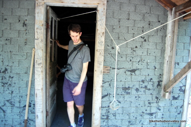
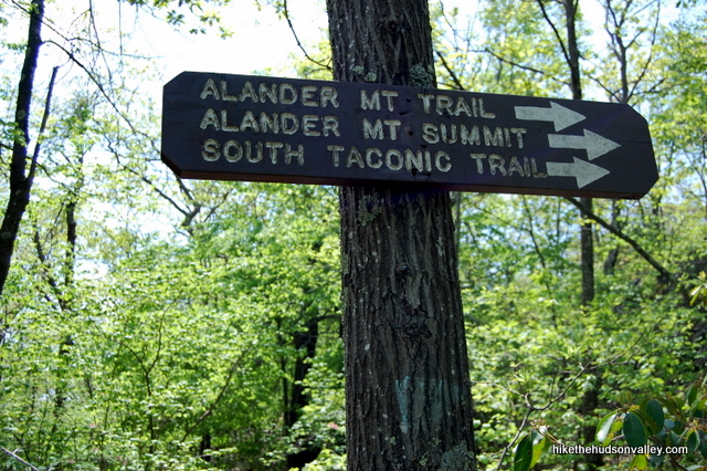
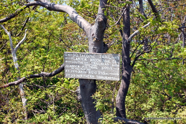
5. Exiting the cabin, look to your left and you’ll see a sign directing you to the right for the Alander Mt. Trail, Alander Mt. Summit and South Taconic Trail. Turn right at this sign to head towards the summit.
6. In just a moment, you’ll arrive at another junction with a sign sticking out of a rock cairn. (UPDATE September 2016: Per Sandy’s helpful comment on my other Alander Mountain trail guide, the sign pictured here is in seriously sorry shape now, and likely won’t be much help to you. The directions below are still valid. so hopefully this won’t slow you down too much! Just visualize an awesome, helpful sign in that cairn and you’ll be all set. Thanks for the heads-up, Sandy!)
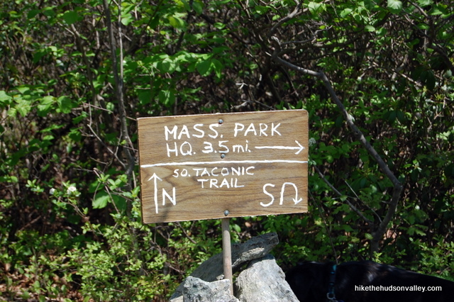
My buddy Ryan and I weren’t sure which way to go here. The map doesn’t say, and neither does the sign. I thought we should go right, he thought left, so we settled it like men: by playing rock, paper, scissors. I won, so we went right first. As it turned out, the biggest views are to the left. Both are nice, but the left fork is definitely the proper final destination. I’ll leave the right fork as an optional step.
7. Optional step: Turn right to head north on the South Taconic Trail and see some nice views. This will add about 20 minutes of hiking to your day, and it will be up-and-back, returning you to this spot. If you want to see them, turn right and head through the thick underbrush for a few hundred yards, stopping when you get to a small, rocky and grassy clearing. The views here aren’t earth-shattering, but they’d be a destination on any other mountain. After you’ve taken them in, return to the junction with the sign sticking out of the rock cairn. (The 8-mile estimate for this hike assumes you did this step — if you skipped it, the total distance for the day would be more like 7.5 miles.)
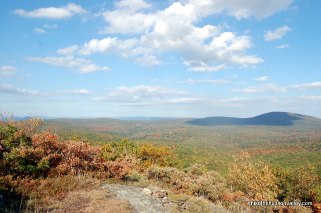
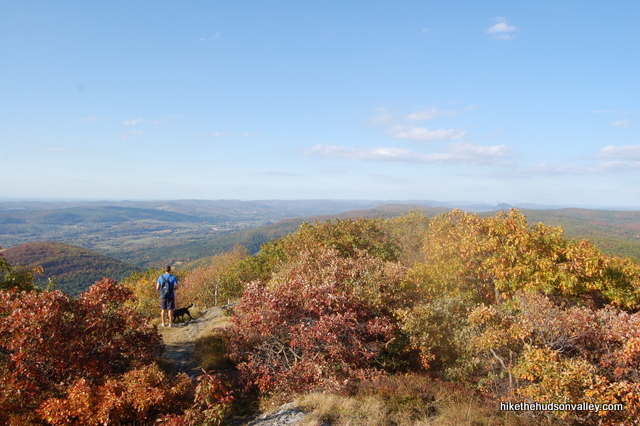
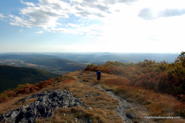
8. From the sign at the rock cairn, head left (assuming you’re coming from the cabin) to visit the huge views, heading south on the South Taconic Trail.
9. Bam! Check out those crazy views.
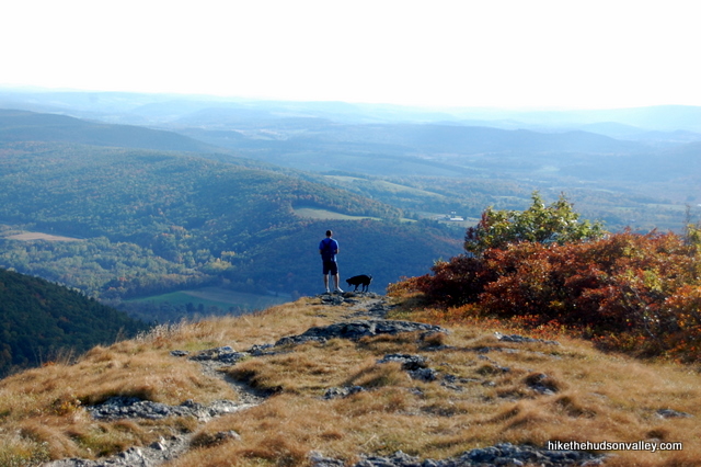
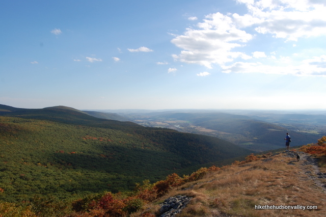
10. Walk down the trail for a couple minutes, making sure you’ve seen the views. There’s no one place along this several-hundred-yard length of trail that is the “best” place to take in the view. If you went nuts and kept climbing downhill, you’d plunge into the woods again, heading down the wrong side of the mountain. Instead, when you see a spot that looks good for a picnic or break, plunk down right there and gaze into the distance for a while.
As a good rule of thumb, you wouldn’t want to go more than a few minutes past the sign on your right that gives mileages to various points of interest.
11. When you’ve soaked it all in, retrace your steps back to your car. Go right at the rock cairn and left at the intersection near the cabin to rejoin the Alander Mountain Trail. From there, it’s just a 3.5-mile hop-and-a-skip back to your car, following the blue blazes the whole way.
Directions
Directions to the trailhead for the 8-mile, gentler loop beginning at Mt. Washington State Forest HQ: From Millerton, NY, head north on Route 22 for 12 miles. Turn right onto NY 344 (Old Rt. 22), and follow signs to stay on 344, which turns into Falls Road as you enter Massachusetts. Go straight past the parking areas for Bash Bish Falls. Turn right onto West Street when Falls Road dead-ends into it. Follow West Street for 2.1 miles, then turn right into the Mt. Washington State Forest HQ just after West Street merges with, and then becomes, East Street. Follow the driveway behind the buildings to park in the large dirt/gravel lot beside the picnic tables. The trail begins at the kiosk.
You can also get directions by checking out the Alander Mountain (Mt. Washington HQ trailhead) entry on the HiketheHudsonValley.com Google map.
Sorta nearby address for your GPS: The intersection of East Street and West Street in Mt. Washington, MA is just a few feet north of the Mt. Washington State Forest HQ, which is on East Street. My old-ish Garmin Nuvi lets me put in an intersection as a destination, so hopefully yours does, too.
GPS coordinates of parking area: 42.08614, -73.46207 (Clicking will open in Google Maps or the Apple Maps app, depending on your browser/device.)
Resources & Interactives
Related resources: If you’re looking for actual facts and/or useful information, visit these resources:
- The official Mt. Washington State Forest homepage
- The official Mt. Washington State Forest trail map
- An excellent alternate hike write-up from BerkshireHiking.com
- General information at the Alander Mountain Wikipedia page
- A nice Alander hiking diary with pictures at AndyArthur.org
- Plenty of nice pictures, including some winter shots, at taconichiking.com
- A steeper, shorter route up the mountain on Hike the Hudson Valley’s Alander Mountain page
More Alander Mountain pictures (covering both routes) from the hike’s Picasa album (with a special thanks to my buddy Jeff Hofer for providing some of these photos):
Was this trail guide useful to you? Please leave a comment!
Want to support trails in the Hudson Valley? Here’s one great way: Visit the New York-New Jersey Trail Conference homepage and click on Volunteer, Donate, or Shop! (Then you can volunteer, donate, or shop, depending on your mood.)
I’ve lost a Rc airplane up on top possibly around bash bish trail just from on top of mountain above the cabin it’s black and white with a reddish orange camera please contact me [email protected] there is a 50$ reward. thankyou..it could be anywhere but there is a good chance someone might come across it..
Hope you found your plane, Wayne!
Hiked this last week – it was great – thanks for the excellent guide!
Definitely hot and buggy. First half of trail is wide and shallow – you can walk 2 in a line, which is nice. Second half a bit steeper. We saw a hangglider coasting (nearly) over us – but other than that, not another soul the whole time.
Great TR! I’m hoping to head out there next weekend (April 29th). I’m actually hoping to come across some rattlers to photograph; has anyone come across them this early in the season? Just for fun, I’ve included a photo of a copperhead I took last week in Connecticut.
Hi Brendan – A friend of mine came across a fairly docile rattler (it didn’t rattle even as he gently moved it off the trail with a long stick) at Gertrude’s Nose in Minnewaska last week, so they are apparently out and about, though he also hiked Alander recently and didn’t see any there. I’ve never seen a copperhead, and hope to keep that streak alive — thanks for the nice picture, which is plenty close enough for me! Best of luck out there, and bring a lens with plenty of zoom 🙂
I saw 3 at alander last weekend. All big all nasty
Whereabouts near the summit? I hear they have a hangout spot near the summit or just before you arrive.
Near the closed area. Just past summit
I have a very specific question about getting to the South Taconic Trail to Alander from immediately below Bash Bish Falls – right at the falls themselves. Here is the question: When I was there, I climbed directly above the falls, where people jump off the rocks over the falls and into the water. While I didn’t jump, I did cross over the creek directly above the falls, and there was a path leading straight up with a guard rail to hold onto. MIND YOU this is NOT the steep path with rail that goes up on the north side of the Bash Bish Brook that goes up underneath the upper MA parking lot and the view point and then onto the creek further upstream from the falls, where people normally follow the blue blazes to meet up with the white South Taconic blazes, instead this is a steep path on the other side of the brook directly above and overlooking the Falls, it starts on the south side of the brook going up and away from the MA parking lot not the blue blazed trail that go up towards it and then onto The S.T.T. If I am to climb this path, does anyone know if it will meet up with the South Taconic Trail and over to Alander?
It seems to be a path to somewhere, or does it just end? Anyone know?
I’m not talking about leaving from the path near the upper Massachusetts Parking lot NOR am I talking about picking up the South Taconic Trail from lower NY parking lot. I’m talking about the (very steep) path on the other side of the brook right above the falls themselves, thank you.
Yes it does. I did that very steep trail late last year. Just pay attention to go left (south) about 35 mins up that trail and that puts you on the stc towards Alander. If some how you miss the turn to head south on the stc the trail heads west ( NY) and it will take you all the way down to the New York parking lot. There are a couple signs in the area where you need to turn south up there so it’s not too hard to figure out.
Hey Bill! Thank You! You are the Man. Is this path what is referred to as the “Side Trail” on that sign up at the juncture? http://www.taconichiking.com/resources/bb5.jpg Which mentions a dangerous brook crossing? It’s neat that there are so many ways to meet up with the South Taconic – from NY parking lot, from MA parking lot, or from the falls themselves. I dig it. Can’t wait to try this route, I may bring a friend and descend on the NY side parking one car over there on undercarriage. I plan to buy a South Taconic trail map eventually from the nynnjtc.org but I’ve been lagging on that and may do this hike before it arrives so much thanks for the info. (Not sure this side path is on the trail map anyway?)
Perhaps it is the “side trail” but I don’t know for sure. I will be out that way in the coming weeks and will confirm.
The NY/NJ South Taconic Trail map 107 is a MUST have. It’s only $7 on Amazon…. get it! It’s awesome map of the entire area.
With that said.. even this map does not detail the steep trail we are talking about; probably a good thing as it is not “child friendly” and you must obey the signs to stay behind the cable fence or else you risk of falling off a cliff….no B.S.
What I can for for 100% certainty that the steep trail is on Bash/Bish mountain which connects at the top-ish….with the STT.
Advice. Before you make a turn south on the STT poke around heading west a little bit until you find some views due west… I think you may even see a sign indicating “Private property”…. if you see this you know you’re in the general spot. Continue to follow the paths around until you stumble upon a big rock out cropping that provides a jaw dropping wide open view of the High Valley Road fields. There are a couple “smaller” views before you eventually find the big one… but follow the path around a bit and you will find it. I chill at the “Big View” for 20 minutes or so then back track east a bit to hop on the STT towards Alander. Hope that helps. …. get the MAP! 🙂
Man thanks. I fell ill with the flu shortly after typing my last response, and there went my vacation time to hike this side-trail up Bash Bish Mountain and on to Alander. Many thanks for pointing that I can head west for some views before turning south. Are you sure it’s a “left” to turn south not a right? I suppose the STT snakes around a bit so you go left and then it turns right/south. I’m looking for another hiking partner for this side trail as well, if you or anyone else is interested. I’ll have a whole week free coming up in a couple weeks, hope to do BashBish/Alander and Mount Race or Brace (haven’t decided) or perhaps both, and maybe explore Bear Rock Falls from the bottom by way of the abandon logging road(s) near the campground. But first things first. I’m a bit leery of the snakes on the Alander trails (and Brace) so looking for a partner in case I get bit, I’ve had a close call before almost stepping on TWO small snakes that blended in well and were coiled together.
You can go up either side of the waterfall (Bash Bitch) to meet up with the STT. The right side is marked “trail closed” when I went, because some of the railing is worn or and there’s debris and erosion or some such. A sign never stopped me from doing anything especially out in nature. I went up the trail closed, right side of the waterfall when looking at it, and was afforded some nice views of the ridge overlooking the waterfall, you then meet up with the path that goes over the creek above the waterfall, and up a bit more onto the juncture where you turn left onto STT as Bill mentioned above. I hiked on a VERY windy day, beautiful clouds and some sun afforded some amazing pictures of the clouds over towards the Berkshire Hills and Greylock in the distance, just really majestic type of sky for pictures (even though my camera is not that great just a point and shoot) I got some real beauties. I did not see any snakes at all, although I though I heard one rustle away into the bush near the shelter, but it could have been a chipmunk although I would lean towards snake. It was not quite as hard as I thought it would be, the steepest section is immediately to the right of the waterfall, and there is a cable there but still a couple tough spots nothing major. I stayed til very beginning of sunset and was hiking in the dark halfway back. Great hike, I would not recommend the easy way from the Mt Washington Headquarters as it must be really easy if this is the hard way, and plus it’s nice to see the Waterfall on the way up and down.
Hiked this excellent loop yesterday, made all the more so for the clear and reliable directions, for which the photos were quite useful. One word of caution (or inducement, depending on your mindset) we encountered 4 very large rattle snakes at the top of the ridge, one of which I had to beat away with a stick so we could get around it!
Was there something preventing you from stepping off the trail a few feet to go around it? Or am I missing something !!??!!? It’s the snakes trail more Than it is yours.
Unreal.
I’m actually trying to figure out how to hike to Alander via Bash Bish falls, hiking the ridge along the South Taconic trail (and back to Bash Bish) if anyone knows which Bash Bish parking area I should start at (MA/NY), and which path to take from the Parking Area, I would highly appreciate it. That pdf map is not so great imo.
Hi Jay:
I did that hike about a month ago; Email directly at [email protected]
Hi Jay! I’ve never done that hike, but if you’re considering putting together a trek like that, this is the best seven bones you’ll ever spend: http://www.nynjtc.org/product/south-taconic-trails.
Hope that helps!
Thank you both. Bash Bish and surrounding is an amazing area so scenic even though the mountains are not gigantic. Seems like there’s quit a bit of snakes up on Alander maybe I should do it with a partner (though I’ve heard Timber Rattlers are pretty docile).. Still, can anybody recommend a good snake bite kit? lol Would help with piece of mind for a solo hike they do blend in very well you could always step on one.
Did this hike when my knees were younger, almost always had the mountain and the sky to myself. Great pictures. Jake
I do this hike (Alander Mtn) at least once a year, if not 2-3 times. It’s a well marked and clear trail with a great reward at the summit. Trails to Bash Bish and alternate hikes if you’re so inclined. One of the best Taconic range hikes.
This hike was beautiful and so worth it! It was our first hkke and though strenuous, not debilitating. We followed the suggestions and found them very clear and helpful. The trail was marked so well. Can’t wait to do the next one!!
Hi, Are there any nice small clearings where one could pitch a tent for an over-nighter up there?
Any info would be greatly appreciated.
Thanks,
Bill.
Hi Bill,
On the official Mass DCR trail map (http://www.mass.gov/eea/docs/dcr/parks/trails/mwashington.pdf), it says: “Camping allowed only at designated campsites or leantos.” I think the cabin in Step 4 is the only overnight possibility up there. Contact info is given on the State Forest homepage, too, if you wanted to check with the people who run the show there: http://www.mass.gov/eea/agencies/dcr/massparks/region-west/mt-washington-state-forest-generic.html. Hope that helps, and hope you have a great visit!
Mike
Hi Bill
There is a camping area about half way up the trail. It is well marked. My husband and I have pitched a tent at the summit in a small clearing a number of times. This is NOT a designated camping area but we’ve never had a problem.
Enjoy!
Thanks for the info 🙂
Mike (and Ryan), I’ve done this hike 3-4 times and am hiking it again tomorrow. And you’re right, it’s a great hike with wonderful views. History – the fire tower that was moved to Columbia County, town of Austerlitz. You can see the footings at the summit.
Nice description and directions, along with your photos.
Thanks for putting it all together and sharing.
Bob
My cousin and I did this hike the end of last October. Fabulous views. Probably one of the best hikes we’ve done thus far! Thank you for your trail guides. We never would have known about these great places without them!
That’s great to hear, Renee! Thank you!
Hi! This is a GREAT guide but I’m still a little confused about the North/South/Mass Park HQ. In the optional step section it says go RIGHT to go north on the South Taconic Trail. Is that correct? I feel like if I saw that sign I would assume right was SOUTH. Also, are there 3 ways to go there? One north, one south and one to the Mass HQ? Or is the Mass HQ the same as one of the other ones? Sorry for this long confusing comment; I’m planning to hike this trail soon and I don’t want to get lost. Me and my friend got lost on a trail last year, got stuck out in the woods after nightfall and had to call the cops for help. Don’t really want to do that again!
Hi Steve — Yeah, to look at it out of context, that sign pictured in Step #6 is probably one of the more confusing signs in the world. The trail dead-ends into a T right there. Going right, indeed, takes you north (to the so-so views), left takes you south (to the frigging suh-weet views), and a U-turn takes you back to retrace your steps to the Mass HQ, where you parked. (It all makes sense when you’re standing there, looking at the sign.) Hope that helps!
This is a pretty straightforward hike, but it’s always a good idea to pick up the map set for the area, too — here’s a link for that: http://www.nynjtc.org/product/south-taconic-trails
Hope that answer helped! Let me know if not. Have a great hike!
Ok Mike, I’m gonna take your word for it. Thanks again for all the awesome guides and the extra fast reply!!
You bet! Have fun out there! (And if I’m wrong, tell the cops I said hi! Just kidding. I promise, it’s right.)