Background
If you find this free trail guide useful, please provide payment by picking up at least one piece of litter on your hike. Cha-ching! Thanks for being awesome! (And here’s a quick primer on Leave No Trace, too, to help us keep the trails nice and fresh for each other.)
Background you can feel free to skip: Out for a neighborhood stroll with the pooch and my son recently, I bumped into Rich and Irene, our very cool neighbors whose sons sometimes look after our house while we’re away.
Irene started talking about her ladies’ hiking group, and how they tackled a section of nearby Appalachian Trail that she knew about from her sons’ days in the Boy Scouts.
“Does it have views?” I asked.
“Oh, yeah, it has some nice ones,” she replied, and I wanted to find out more.
About a week later, amidst the usual junk mail, I found a nice trail description from Irene in our mailbox, detailing the section of Appalachian Trail that runs through Depot Hill Multiple Use Area. I’d heard of Depot Hill before; my trusty old trail guide talked about it, but the hike there involved a bushwack and had no views, so I’d never felt the urge to check it out.
The hike in Irene’s trail description sounded much more promising: a climb along the top of a ridge to the summit of Mt. Egbert, with views across Dutchess County to the Catskills and Hudson Highlands.
A couple of weeks later, the dog, the baby and I took a walk at Depot Hill (while the wife relaxed with an empty house – we call it her Moment of Zen), and it certainly won’t be our last trip there. It’s not a flat walk by any stretch, but you park at the top of the hill and follow the ups and downs of the ridge as it leads to the top of Mt. Egbert, which you’ll summit without even realizing, just after passing an Appalachian Trail shelter. The rocky overlook just past the summit is a great place to relax and soak in some views. It’s everything you could want in an afternoon hike. And, as I’d find out later, a pretty excellent sunset spot, too.


So head on out to Depot Hill Multiple Use Area and check it out. And if you visited based on this recommendation, when you get to the view on Mt. Egbert, say, “Thanks, Irene!”

Trail Guide
Bonus unsolicited advice: Don't depend on having cell service in the woods - it can be spotty out there! Download this trail guide to your phone before you head out. (It's easy to do on iPhone and Android.) May your connection to nature be strong, even when your connection to the internet is weak.
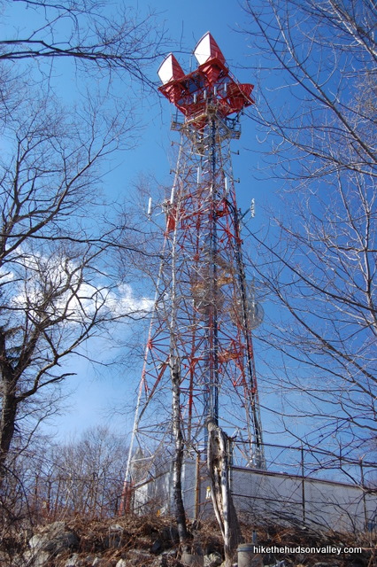
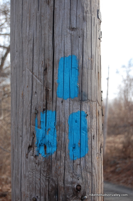
1. Facing the giant communication tower that overlooks the parking lot, turn left and walk south down Depot Hill Road. You’ll see the blue trail markers on the phone pole marking the beginning of the hike.
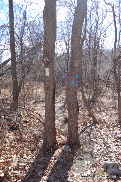
2. Head downhill for a minute or two before arriving at the intersection with the white-blazed Appalachian Trail. Turn right here and head south on the AT, towards Georgia (but we’re not going quite that far today). Three blue blazes here mark the end of the Blue Trail. Goodbye, Blue Trail. We hardly knew ye. But we’ll see you on the way back.
3. Just keep following those white Appalachian Trail markers. The summit of Mt. Egbert is just less than 1.5 miles away.
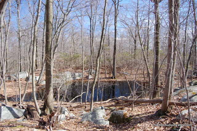
4. About fifteen minutes in, you’ll pass a small pond on your left (it might be dry if you’re here in the summer).
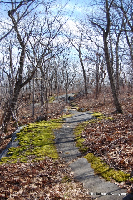
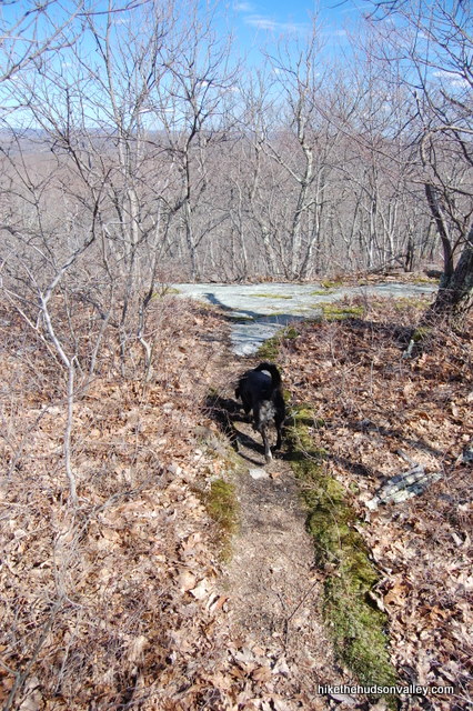
5. The trail is quite rocky in parts, sometimes requiring careful stepping. And in other parts, the trail cuts over huge, flat, moss-covered rocks, making it look like nature has rolled out the gray carpet for you.
6. Depending on your pace (it was about 25 minutes for me), keep an eye out on your left for a very short spur to a nice flat rock with a decent overlook. You probably won’t want to stop here for too long, but in a pinch, this could make a very nice lunch or sun-catching spot, with plenty of room to spread out.
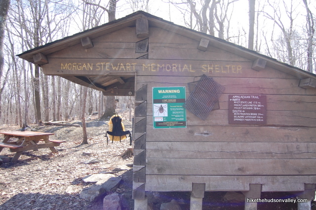
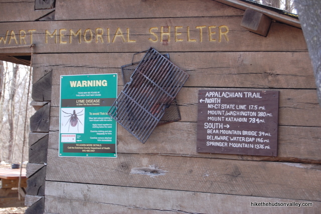
7. The trail keeps meandering through the woods with some decent climbs, generally heading uphill, but you never really have the feeling that you’re scaling a mountain. You know you’re getting close when you pass the Morgan Stewart Memorial Appalachian Trail Shelter. There was somebody in there when I walked by, so I didn’t bother them. But it looked like a nice place to hang out. You can also look at the sign on the side of the shelter to check your distance to Maine (734 miles) or Georgia (1,376 miles), in case you decide to make a much, much longer day out of it.
8. Just past the shelter, you’ll summit Mt. Egbert on the White Trail (it took me about two minutes). You might not notice, unless you see the small cairn and USGS marker just off the trail. Whether you see the marker or not, hey, you just climbed a mountain!

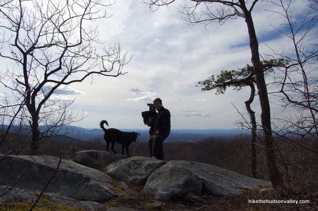
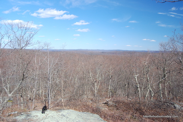
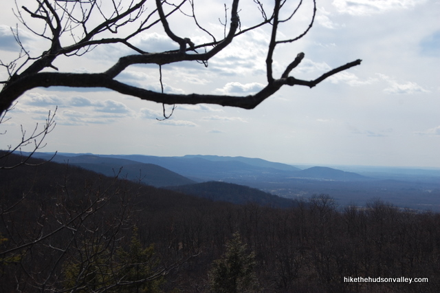
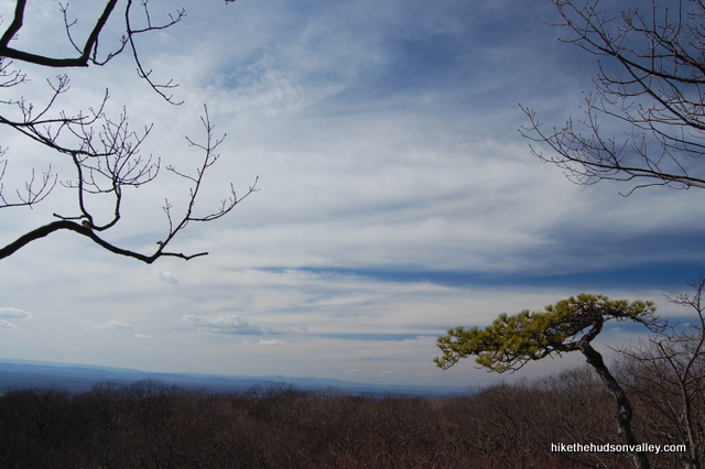
9. About ten minutes after the shelter, you’ll arrive at the overlook, which opens out in front of you with some inviting rocks to chill out upon. You can see clear across to the Hudson Highlands on your left, and the Catskills rise up on the horizon to your right. There’s a very photogenic little pine tree right there that likes to photobomb your landscape shots, too.
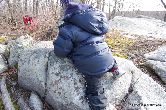
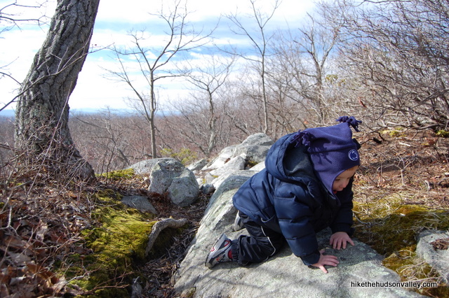
If you’re carrying a toddler on your back, he might want to do some carefully supervised rock scrambling of his own right here.
10. Once you’ve sufficiently soaked it all in, head back the way you came. Follow the White Trail 1.5 miles back to the gravel road, where you’ll turn left on the Blue Trail and head up the hill to the communication tower and your car.
11. Thanks, Irene!
Directions
Directions to the trailhead: From the Taconic Parkway, take the Beekman Road exit and head east. Take an immediate right onto Phillips Road and follow it until it dead ends into Route 216. Turn left onto Route 216 (you won’t know it’s 216 until after you make the turn, since the Route 216 sign isn’t visible from the end of Phillips Road, of course). Stay on 216 for 3.6 miles, then turn right onto Depot Hill Road. The parking area is 1.9 miles ahead on your left, at the top of Depot Hill, just under the big ol’ communications tower.
You can also get directions by checking out the Depot Hill entry on the HiketheHudsonValley.com Google map.
Sorta nearby address for your GPS: UPDATE 1/11/19 – Thanks to Jonah’s helpful comment below, we have a GPS address that works pretty well:
301 Depot Hill Rd
Poughquag, NY 12570
Just keep heading up Depot Hill Road to find the large dirt parking area on your left, just below the massive communication tower. (You can apparently come up Depot Hill Road from the south as well, but it is unmaintained south of the trailhead parking, and that stretch of road looked more like a jeep trail to me – it’s very rough. UPDATE 4/19/2015: Thanks to Indra’s comment below, we now have better directions to the trailhead if you’re coming from the south. Thanks, Indra!)
GPS coordinates of parking area: 41.57261, -73.68086 (Clicking will open in Google Maps or the Apple Maps app, depending on your browser/device.)
Resources & Interactives
Super-cool Google Earth flyover of hike route:
Google Terrain Map of hike route:
Related resources: If you’re looking for actual facts and/or useful information, visit the Department of Environmental Conservation’s Depot Hill Multiple Use Area page. You’ll also find a link to a Depot Hill map there, but that map won’t do you any good on the hike I’ve described above, since the Appalachian Trail doesn’t appear to be marked on it. Feel free to look at the map for the pretty artwork, though.
More Depot Hill pictures from the hike’s Picasa album:
Want to support trails in the Hudson Valley? Here’s one great way: Visit the New York-New Jersey Trail Conference homepage and click on Volunteer, Donate, or Shop! (Then you can volunteer, donate, or shop, depending on your mood.)
Mike: Thanks so much for this guide. I remember the first time I went to Depot Hill (pre HtHV) I wandered around not knowing how to find my way to the Appalachian Trail. I thought the Depot Hill trail would take you there. Big mistake. Your guide saves a lot of time by directing people to take the short trip on Depot Hill Road and the entrance is right there. There’s nothing at the parking area that indicates where you’re supposed to go. I hiked the up and back today on a windy Spring day. Very enjoyable. The rocky areas you mentioned are a bit difficult, but well worth it for the awesome views at the top. Saw one person at the shelter on the way back, otherwise the trail was empty. Thanks again for your incredible write-ups.
So glad you had a great day out there, and that this trail guide was useful to you, Dave! I really appreciate your kind words, too – thanks so much for taking the time to comment. Happy adventures to you!
Pingback: Where to Go Hiking With Kids in the Hudson Valley
Went today! Open! Not many people at all. Quite an easy hike. Maybe an hour in and an hour back at a leisurely pace. Wicked lichen growth! Nice little viewpoint!
Pingback: Where to Go Hiking With Kids in the Hudson Valley
Hi Mike,
I was wondering which hike, Nuclear Lake or Depot Hill is more scenic. Also, are either of them super popular?
Thanks,
JBK
Hey there, JBK! They are both scenic in their own ways — Nuclear Lake doesn’t have a view unless you trek all the way up to Cat Rocks, but the lake itself is quite beautiful. Depot Hill has a nice (though not gigantic) overlook, but no beautiful lake to gaze across. I’d recommend checking them both out when you can — neither one is super-popular like Breakneck Ridge or Mohonk, though they do both deservedly attract some visitors, especially on nice weekend days. Hope that helps – enjoy whichever one you decide to check out (first)!
Well, it’s been over a year since that comment was written, but looks like I am probably going to go hiking in this area on my next hike. I was thinking about parking on Stormville Mtn Rd by I-84, and then hiking up to the overlook and back – would this be a good idea? Also, I’m in NYC, so what is the snow situation like? Would it be ok to do this hike wit current snow levels?
Greetings from the future, JBK! Nice to talk to you again. 2020 sure was something, wasn’t it? I’m afraid I’ve never hiked that section of the AT before, but it theoretically looks like a workable plan. Please let us know how it goes if you give it a shot! The snow situation up here is deep (8+ inches, and more in higher elevations), and only going to get deeper over the next few days. I wouldn’t attempt this hike without at least micro-spikes and gaiters (and perhaps snowshoes if you visit after Thursday/Friday, when we’re supposed to get another 7+ inches). Good luck whenever you visit – hope you have a great hike!
2020 WAS something! I’m going in ~2 weeks, but since I don’t microspikes, I think I’ll try to find something on a flatter trail, maybe in Fahnestock with the carraige roads and all.
Thanks for the advice!
I picked up a pair of micro-spikes on Amazon for $23 this year — they do open up the world this time of year if you’re up for adding to your gear collection, and there are plenty of cheap options. Or it looks like we may be in for some melting here soon, so a little patience should do the trick, too. Good luck with whatever you decide to do, JBK!
Well, looks like the snow now appears to be melting, so I’m thinking about planning a hike this weekend. Would this hike still be a microspike required hike or not? If it is, I’ll look into getting some microspikes, but do you have any ideas of non-microspike hikes in the area? Thanks!
Hey there, JBK! We did have one warm day this week that may have melted the snow on some trails, but there’s still plenty of snow/ice on the ground, and the highs are going to be in the low 30s through the weekend. I wouldn’t venture into the woods quite yet without traction devices of some sort. Soon! But not yet. There is almost definitely still ice on this trail. Rail trails and perhaps some of the mansion grounds that have full sun and pavement for melting the snow/ice would probably be the best spikeless options for the time being. My vote is to pick up some spikes, toss them into your pack, and head out there! I hope that’s helpful — good luck if you head out this weekend!
That section of AT is right behind my house. I’m at about 1000 ft and there’s still a good 8″ on the ground.
That’s very helpful, Frank – thanks for the up-to-date info!
Great hike! Not too easy, not too hard, with a beautiful and rewarding view. And I only saw one person on the trail (too many people tend to ruin my nature). I also picked up a piece of litter, which made me feel like a better human at the end of the day.
Love your website, it’s helped me discover so many new hikes I may not have otherwise known about! Both informative and entertaining 🙂 Thanks and keep up the good work!
You made my day today, Caitlin — thank you so much! And thanks for your litter removal services, too! Here’s to many more happy adventures out there 🙂
Hi Mike,
You can also put this address into Google Maps and it will take you to the trailhead. Thanks so much for the great website!!!
Address: 301 Depot Hill Rd, Poughquag, NY 12570
Thanks for the tip, Jonah! I’ve updated the “Directions” section with your suggestion and a link down to your comment. (I also removed my paleolithic advice that mentioned a Garmin Nuvi, which are mostly only useful now from an archaeological perspective.) Much better now — thanks so much!
Completed this hike on Saturday morning. The weather was iffy, and so this seemed like something I could squeeze in before the afternoon. Pretty nice overview at Mt. Egbert, and seeing the shelter was cool. This would be a good short hike to do with kids. Nice exploring another part of the Appalachian Trail I hadn’t seen. After climbing 5 of the Adirondacks high peaks the previous weekend I needed to dial it back anyway.
Did this hike last weekend, perfect for beginners and was very easy. Enjoyed the view at the end. Passed a lot of hikers throughout the trails.
My husband and I tackled this hike with our 8 month old son and two dogs. Gorgeous hike on a beautiful day! Doesn’t get any better! We have done many of your hikes and can’t tell you how much we appreciate all of your hard work!! Thank you!!
Awesome, Lindsay – that’s great to see! Thanks so much!
Hello Lindsay!
I have to ask.. is that Brad from AHS ‘98?!
I just happened on this site from an article in HVMagazine – Depot Hill caught my eye and I’ve been wanting to get my kids outside doing something fun and together! Lol
Can’t wait to go for it – and hear from you!
Jenn 🙂
This was an easy hike (4/10 difficulty) with only 1 overlook that we found during peak foliage in Oct. A little disappointing but a nice walk through the woods nonetheless. I would give it a 2 out of 5 for scenery. The other hikes are usually spot on with this website’s rankings.
Hey Jason — You could sell me on a 4/10 difficulty rating, but 2 of out 5 cameras seems low to me for that overlook. Maybe I’m biased because this one is pretty close to home. Hope you find some more nice spots to explore before the fall gets away from us!
My boyfriend and I just did this hike this weekend. We never saw the lake, not sure if it’s dried up or just covered by all the leaves that have fallen with the colder weather. We were worried that we had done something wrong when we didn’t see the lake, but if you just keep to the well marked white blazes you’ll come to the the beautiful overlook after the shelter. You really can’t miss it!
Thanks for the confirmation that the lake does indeed dry up seasonally, Liz. Glad you all had a nice day out there!
Did Depot Hill today (Labor Day) and there were only a handful of other hikers. That’s amazing for a holiday hike! Your directions/descriptions were perfect. We hiked about 30 minutes past the lookout point which made it closer to a 3 hour hike. The bit past the lookout is a little more steep rock scramble for anyone who’d like to extend this hike. We didn’t go far enough to get to another lookout. Thanks for a great hike list!
Thanks for the nice words and the info, Shannon – I’ve never ventured past the overlook, nice to know what’s out there!
Looks like a nice sunset. Is there enough time to get back to the trail head before dark?
Took this short hike today with my 50 lb pitbull. This was like the perfect short exercise. Not really much of a challenge, but you’ll sweat a bit and feel like you’ve got something done. The AT Shelter was cool to see and made me think “Hmm, I wonder if I’ll ever try to tackle the AT at some point in my life?”
The Payoff was sufficient for the effort. If you’ve only got 90 minutes for a quick hike, you can get this one in and be on with your day!
Just did this hike today. Great directions. I woudn’t have known about this had I not found your website from a random google search. We thought we had done most everything in the valley, but now we have a long list of new ideas. Thanks!
Just a word of caution about the dirt road from the parking area to the trail. When I was hiking here with my family yesterday afternoon there was a red pickup practicing his World Rally Racing who came fishtailing around the corner. He lifted (a little) when he saw me, but sped up and turned up the phone tower road.
This is a great short hike for people who don’t like hiking (yes they do exist!).
Taking a break at the ‘top.’
Wanted to do a quick hike this morning before it got too hot. Not only was it a nice, relaxing stroll, but I must’ve met @ 5 people that were thru hiking on their way down to Georgia! Two guys in particular said they started in Maine on June 1st. and were continuing down. That’s awesome!!!!!
Just did part of this hike–I came from the other direction starting where the Appalachian Trail crosses Route 52 and finished up on the trail before getting picked up on Depot Hill Road. What amazing views! For me, one of the best parts of the hike is that the Appalachian Trail here does not require dogs to be leashed. What fun my pup had! I would have never done this hike without seeing this website and it’s pretty much right in my backyard! I decided to share a picture from the summer season to the site. I look forward to doing this hike to see the sunset in the future.
Hi Mike,
If driving from points south, it’s best to use the intersection between Route 7 and NY 216 in Poughquag as the GPS destination. Otherwise the GPS will try to take you through country lanes to the unmaintained section of Depot Rd.
(The Shell gas station at said intersection also has a bathroom.)
You can then go west on 216 and turn left on Depot Hill Rd. Follow for 2 miles to the tower.
Indra,
I just updated the GPS directions section to point down to your comment. This is very helpful – thanks so much!
On another note, your description of this Level 5 hike was accurate and helpful. We’re going to try a Level 6 next! Thanks for putting together this great resource!
Just took the hike today with my dog Roscoe. The trails were still snowy, and the temp. was @ 40 degrees. Couldn’t have asked for a better day! The shelter was not in use, so we hung out for a few before returning back. Great hike!
Awesome, Tom! We were just getting ready to head out for a hike today, too, when the rain rolled in. Glad you and Roscoe got out there earlier than we did!
*white trail, not way.
At the shelter now. Can’t find the summit anywhere “just past the ahelter”. have continued further on the way trail but cannot find anything at all. Very disappointed.
The shelter is about 2/3 of the way to the view – keep heading on the White Trail and you can’t miss it!
So sorry to see a comment like this, Beth! I’ve updated the trail guide with more exact language. The view is about ten minutes past the shelter, you just keep heading straight on the White (Appalachian) Trail. The summit is two minutes or so past the shelter. You’re right — “just past the shelter” could mean anything, and I’ve updated the guide so other people won’t run into similar problems. Hope you found the money spot after you left these comments! (The server is having some issues and won’t let me upload my changes right now, but I’ll keep trying until I can.)
Thanks Mike. We did continue along the white trail for about another 10 minutes but I was getting nervous as we were close to the time where the sun would start setting. I had a funny feeling we were close but not knowing for sure, I didn’t want to take a chance. We’ll be back soon – it’s a short distance from home!
BTW, I LOVE this website you’ve created. When I came across it (via Facebook initially), I had done a lot of the hikes you’ve listed but it has been so much fun using it to do all of the hikes I haven’t! We’re checking them off one by one. It was the perfect site to use yesterday when I just wanted to find someplace close to home for an easy, quick hike. Never knew about Depot Hill until I found it here. So, thank you for all of the effort you’ve put in creating and maintaining it. It’s fantastic. Kudos to you!
Glad that site has been useful for you, Beth, and thanks for the kind words! I was finally able to update the trail guide — it now gives some specific times, rather than just saying, “Eh, you know, there’s a view somewhere.” Thanks for helping me to improve the site, and I hope you get some nice shots of the view on your next visit to Depot Hill!