Nobody actually asked me any of these questions, but if they did, here’s how I’d answer ’em:
1. Why should I trust your trail directions?
2. How did you come up with the scenery ratings?
3. How did you come up with the difficulty ratings?
4. What other resources would you recommend?
5. Your writing sucks. How can I avoid seeing more of it?
6. Are you aware that there is a baby on your back?
7. If something bad happens to me out there, can I sue you?
8. What are all those funny markings on the trees?
9. Is it appropriate to bring kids on these hikes? Dogs?
10. Why aren’t there more long hikes (5+ miles) listed on this site?
11. Dude! I found a mistake in one of your trail guides. What gives?
12. Uh, why’d you do this?
13. Can we talk about photography?
14. Hey, these are all day hikes! What if I wanna sleep on dirt?
15. Can I blast music on my Bluetooth speakers (or any other device) while I hike?
16. Am I detecting a few more ads on the site?
1. Why should I trust your trail directions?
My name is Mike Todd, and I created all the trail guides on HiketheHudsonValley.com. When I first moved to Poughkeepsie in 2000, I didn’t know a soul. I’d just started interning at a little international computer company (you’ve probably never heard of it), and after work, I had absolutely nothing to do that didn’t involve a PlayStation2. So I went to Barnes and Noble, bought a hiking guide, and started checking out some of the places around here.
I couldn’t believe what I found. For me, growing up in southeast PA, hiking had always been something to do once a year, when my family went on vacation in Maine. But in Poughkeepsie, you can drive less than an hour in any direction and arrive at a gorgeous new natural place to explore. I still feel lucky every day to live in a place where you can go on vacation after work on a Tuesday and be home before dark.
Eventually, I started leading a weekly hiking group during the summers. I did that for five years, and not a single person died the whole time.* That’s why you should trust me. Oh, and I got my Eagle Scout in high school, so I can also tie a bowline.**
*that I noticed
**no I can’t
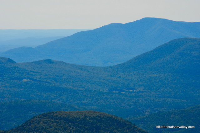
2. How did you come up with the scenery ratings?
Some people might argue that it is impossible to assign a number to nature’s beauty, but all the hikes in Hike the Hudson Valley have been subjected to the Scientific Scenery Rating System, a rigorous set of tests that objectively determine a hike’s proper rating on a scale of 0 – 5 cameras. If you don’t agree with any of these ratings, you’ll have to take it up with science.
| Scientific Scenery Rating System | |
|---|---|
| No Cameras | Trail possibly booby trapped |
 |
Industrial waste somehow involved |
 |
Better than being inside |
 |
Not too shabby |
 |
You might text home about it |
 |
You might update your Facebook status about it |
 |
Dude, I can’t believe I forgot the camera |
 |
DUDE, I CAN’T BELIEVE I FORGOT THE CAMERA!!! |
 |
Scenery knocks one sock off |
 |
Scenery knocks both socks off |
 |
Scenery literally makes love to your eyeballs* |
* Yes, literally.
3. How did you come up with the difficulty ratings?
The hikes on Hike the Hudson Valley are rated by difficulty on a scale of 1-10. To help you better choose a hike with the difficulty level you’re looking for, here’s the Scientific Hike Difficulty Rating Scale I used to determine those numbers.
| Scientific Hike Difficulty Rating Scale | |
|---|---|
| 0 | You haven’t gotten out of bed yet. |
| 1 | Similar to the walk from the couch to the fridge. |
| 2 | Tingly sensation spreads across the lips. Wait, no, that’s 2 peppers on a Thai menu. |
| 3 | Okay, this is starting to feel like a hike now. |
| 4 | Last safe number on which to bring friends who don’t like hiking. Starting to feel a lot like exercise. |
| 5 | If you don’t break a sweat, you might be a cyborg and not even realize it. Yet. |
| 6 | You owe yourself at least three slices of pizza after this. |
| 7 | This might hurt tomorrow. |
| 8 | And the next day. |
| 9 | And the day after that. |
| 10 | Would make Bear Grylls cry for his mommy. |
4. What other resources would you recommend?
I) The books that made the Mid-Hudson Valley come alive to me were two trail guides by Peggy Turco:
- Walks and Rambles in Dutchess and Putnam Counties (newer version here)
- Walks and Rambles in the Western Hudson Valley
These books are fantastic and packed full of interesting information about the area. I highly recommend them.
II) I link to this site throughout Hike the Hudson Valley, but if you’re doing any hiking in CT, MA or eastern NY, BerkshireHiking.com is a fantastic resource with detailed, spot-on trail guides.
III) Many of the hikes listed on Hike the Hudson Valley wouldn’t exist without the excellent work of the New York-New Jersey Trail Conference. They have a nice online Trail Finder for New York.
**UPDATE 3/24/2014** Holy cow! They have a new Find a Hike that is super-comprehensive and awesome, linking to their excellent online trail guides. Highly recommended!
They also sell some fantastic waterproof, tear-resistant maps. I got these as Christmas presents last year, and I really wish I hadn’t been too cheap to just buy them sooner. They’re excellent:
- East Hudson Trails
- West Hudson Trails
- South Taconic Trails
- Catskills Trails
- Shawangunks Trails
- Harriman-Bear Mountain Trails
There’s also a very limited subset of maps available to download for free. But you should really buy some of their paper maps — if you like hiking around here, you need to have them.
5. Your writing sucks. How can I avoid seeing more of it?
Great question! For starters, the last thing you’d ever want to read is my weekly column, which runs in a few small newspapers outside of Philly, near where I grew up. After those columns run in print, I post them on my blog at justhumormeweekly.wordpress.com, so you should definitely not click that link.
Otherwise, just shutting your eyes or closing your browser should do the trick. Good luck!
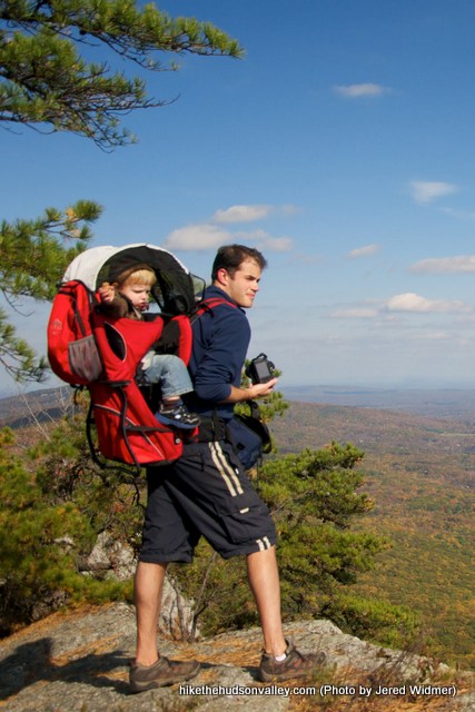
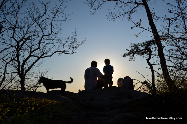
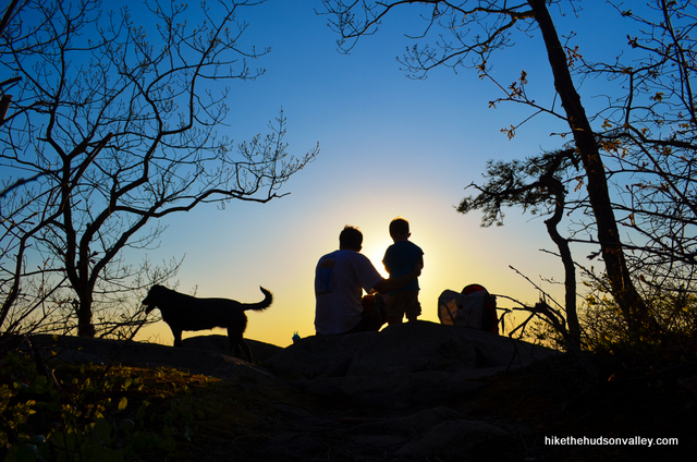
6. Are you aware that there is a baby on your back?
AAAAAAHHH!! Get it off me! Get it off me!!!!
But seriously, this pack from Kelty (a gift from my awesome sister-in-law and her awesome husband) is the greatest thing in the universe. When our son Evan was teething, he’d be cranky and going nuts. Consequently, we’d all be going nuts. But when I’d throw him in this thing and head out in the woods, he’d be happy all day long. Taking Evan on hikes to preserve the sanity of our household is how I got back into hiking again, after taking a couple years off. I can’t recommend this pack highly enough.
7. If something bad happens to me out there, can I sue you?
I think a much better solution would be to avoid anything bad happening in the first place. If you’re new to hiking, or even if you’re not, please take a moment to review these Day Hiking Guidelines (written for the Adirondacks, but good advice no matter where you hike) and these 10 hiking safety tips. Following those tips will help limit your exposure to the risks inherent with heading out into the woods. Hike the Hudson Valley is meant to show you some great places to visit, but it’s your responsibility to prepare and make good decisions out there.
I’ve taken care to make sure these trail guides are accurate, but I can’t guarantee that the trail conditions haven’t changed since my last visit, or that I didn’t say “turn left” when I meant to say “turn right.” (If you find an error, please let me know so that I can update the page as quickly as possible.)
When online trail maps are available, I’ve linked to them in the write-ups. I’ve tried my best to tell you everything you need to know to successfully complete each of these hikes, but it’s a good practice to always have a map with you before tromping off into the wild green yonder.
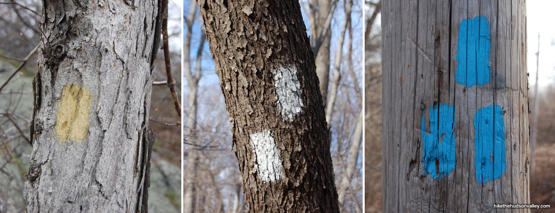
8. What are all those funny markings on the trees?
Just in case you played hooky on the day they explained how trail blazes work, here’s a handy-dandy graphic from the informative Wikipedia page on trail blazing:

You might see some variations on these markings, or a given trail might ignore them altogether, but it’s good to know these patterns as a rule of thumb.
9. Is it appropriate to bring kids on these hikes? Dogs?
For the majority of these hikes, yes, that would be a fantastic thing to do with your kids, assuming that you’ll watch them closely, and that you’ll choose a hike that matches their ability level (and that you’ll bring plenty of snacks and water). In general, hikes rated a 5 or lower should be pretty friendly for most kids.
If you’re lugging a small child on your back, anything rated a 6 or higher on the difficulty scale should probably give you pause. I’ve lugged my son Evan on my back on most of these hikes, and I’ve made note in the trail descriptions if there are any spots that would be difficult, dangerous or impossible with a kid on your back.
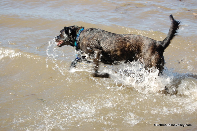
Almost all of the hikes described on this site allow dogs on leashes, with a few notable exceptions. “Dogs on leashes” is the default, and I’ll make a note of it in the full trail guide if that’s not the case.
**UPDATE February 28, 2014** From the comments below, it seemed like it might be useful to go ahead and call the no-doggie hikes out by name. Here’s a list of dog-questionable hikes:
Dog-hoisting required:
Breakneck Ridge
Indian Head Mt. & Twin Mt.
Sam’s Point (ice caves only, not waterfall trail)
Wittenberg Mountain
Dogs allowed but I think it’d be crazy to bring ‘em:
Bonticou Crag
Dogs not allowed:
Mohonk Mountain House
Constitution Marsh
Stissing Mountain
Silver Sands State Park
w00f!
10. Why aren’t there more long hikes (5+ miles) listed on this site?
One time in college, I took a bunch of friends on an expedition to Hawk Mountain in eastern Pennsylvania. The hike ended up being an 11-mile round trip. In the group photo at the end, every person in the picture was giving me the finger.
Some people enjoy hiking ten miles in a day. Most people don’t. For me, 3-5 miles is the sweet spot, getting some good exercise and seeing some nice sights. Too much less, and it feels like you didn’t even get started. Too much more, and the fun-to-blister ratio starts to skew in the wrong direction.
Some hikes need to be longer to make sure you see what there is to see. But in general, if I have a choice, I’ll try to keep it in the 3-5 mile range, and let you know if there are options to do more, should you be one of those people who sweats Power Gel and keeps a Clif Bar in an ankle holster.
11. Dude! I found a mistake in one of your trail guides. What gives?
First, thank you for phrasing that as a question. Second, please, please, please, send me an email so that I can correct the error. I write the trail guides with a light-hearted style, but I take the accuracy of those directions very seriously. I’ve been lost in the woods with a crappy trail guide before, and I know how terrible that feeling is, and how dangerous it can be. I’ve made every effort to be accurate and clear with my write-ups, but if there is an error, or you couldn’t figure out which way to go based on the words I used, or a trail condition has changed, I want to know about it and get it corrected as soon as possible.
I consider the user reviews for this book to be a cautionary tale.
When my friends would ask me about places to hike around the Hudson Valley, I thought, man, wouldn’t it be nice if there was a site that had all the information you needed? Then I could just send people a link and they could explore all these hikes for themselves. I couldn’t find a site like that for this area, so I thought it would be a fun project to create one. Launching Hike the Hudson Valley has combined all the things I love to do in my spare time: hiking, writing, taking pictures and wasting time on the Internet. I hope it’s a useful resource for you.
13. Can we talk about photography?
Someone actually asked me a question! I know, I don’t really believe it, either. But let’s take a look anyway:
Hi. I’m a big fan of your site and the Facebook page. Thank you for providing such a fantastic (and entertaining) resource. As a hiker, and an aspiring amateur photographer, I find particular inspiration in the amazing images that you’ve put online. Would it be possible for you to share maybe some tips for those of us who want to take our DSLR with us on the trail, maybe a particular type of lens (or lenses) that you consider essential for great hiking and nature/landscape photography, or type of tripod (if any) that you recommend, or equipment bags and carrying methods?
Thanks,
Mike Arcigal
Oh, I wouldn’t call the images AMAZING, but you know, if you want to call them that, then I’ll just have to reproduce your words verbatim and put them on my website. And capitalize the word AMAZING in case anyone missed it.
Really, thank you, Mike, for the very kind words and flattering question (and permission to reproduce your words here). I shall attempt to give a non-terrible answer.
Let’s start with the easy stuff – gear recommendations. I’m usually lugging a child on my back, so I try to keep the gear to a minimum. The essentials:
1) Tripod. You need this to get yourself in the shot, but also to take waterfall pics or low-light shots, where the shutter needs to stay open longer. I have two tripods:
– A GorillaPod. This thing lets you set up the camera pretty much anywhere, as long as you have a rock or a tree or something to attach it to (you can shoot from about six inches off the ground, too, if that’ll work for you). I used it to take these shots:
– A Zipshot. A full-size tripod that weighs next-to-nothing. I just got this recently, but man, it’s nice to have a full-size hiking tripod that you can set up in two seconds, and tilt the head for landscape and portrait shots. I don’t have any winners taken with it so far, but I hope to have some soon. I’m thinking my GorillaPod just got demoted.
2) Remote control. Great for firing the shutter from several feet away, and for taking long-exposure shots without your sausage fingers rocking the camera when you press the shutter button (which will make everything blurry). You can attach the remote to the camera strap so you always have it. Say cheese!
3) Polarizing filter. Want blue skies? You need a polarizer.
4) Lenses. For hiking, I just use the 18-55mm kit lens that came with the camera. It’s fine for landscape shots and outdoor people pictures, and it’s compact and light. If I’m not toting a kid on my back, I’ll also bring the 55-300mm zoom, on the off chance I get close enough to a critter to take a shot.
A zoom lens also lets you create a different take on the view in front of you.
Without zoom (18mm):
With zoom (300mm) – here’s a shot of the peak just to the left of the bird in the above pic:
For indoor shots and people pictures, I highly recommend getting a nice, quick prime (fixed focal length) lens. I have two, 60mm and a 35mm, and they’re awesome. Much better at grabbing low-light shots without a flash, and people pictures just look better with them. The 35mm f/1.8 is one of the cheapest lenses Nikon makes (it’s 200 bones or so). When I’m in the house, it’s always on my camera.
5) For carrying the camera, I just have a simple $20 camera bag with a belt loop that I wear on my backpack’s waist strap. You can kinda see it here:
If I don’t have the big kid-carrying backpack on, I just throw the camera bag into a regular bookbag-style bag.
6) Add-on flash! On my old Nikon D40, the pop-up flash broke, and it was the best thing that ever happened to my indoor photographs. This really has nothing to do with hiking photography, but I couldn’t write all this stuff without mentioning the add-on flash. Fancy people call them speedlights. I have the simplest Nikon one you can buy (the Nikon SB-400), and it has made my on-board flash completely obsolete. I don’t know why they make onboard flashes so crappy, but even on my new camera (a Nikon D5100) with a functioning flash, I can’t bring myself to use it anymore. Here’s why.
Onboard flash:
SB-400 speedlight, pointed up to bounce the flash off the ceiling:

See what I mean? It just makes everything better. It’s the #1 piece of general photography gear that I’d recommend, even though it won’t really do diddly for your outdoor pictures.
7) Crap, I’ve spent a lot of money on camera stuff.
For non-gear-related tips, honestly, I shouldn’t be dispensing advice. Two confessions that I’m ashamed to make: I almost always shoot in full-auto mode, unless I’m trying to do something specific with depth-of-field (in which case I’ll shoot in aperture priority) or shutter speed (then it’s shutter priority). I mean, dude, the engineers at Nikon know what they’re doing. Who am I to override them? Plus, I usually have a kid on my back, and if I stop for more than three seconds, he’ll start screaming. I can’t be futzing with the settings for every shot. So there. I confessed. Oh, also, I shoot in JPG, not RAW, which further disqualifies me. 17MB per picture? I don’t think so. The highest resolution JPGs (more like 6MB) are good enough for me, and they blow up to an 8×10 no problem. Serious photographers shoot in manual mode, and they shoot in RAW. That’s why I’m a picture-taker, not a photographer.
But given that disclaimer, here’s some advice anyway. What the heck.
1) Take 17 bazillion pictures. They’re free! Go buck wild. If there’s action going on, set the shutter to burst mode so it’ll keep firing while you hold the shutter button down. If I go for an all-day hike, I might come home with 900 pictures. From those, I’ll hope to have 10 or 15 winners.
Most of them come out like this:
But a few come out like this:

2) If you haven’t already read up on photo composition, here’s a nice primer. The rule of thirds (the first one in the list) is probably the most commonly known, and it really does help to keep that one in mind as a nice rule of thumb.
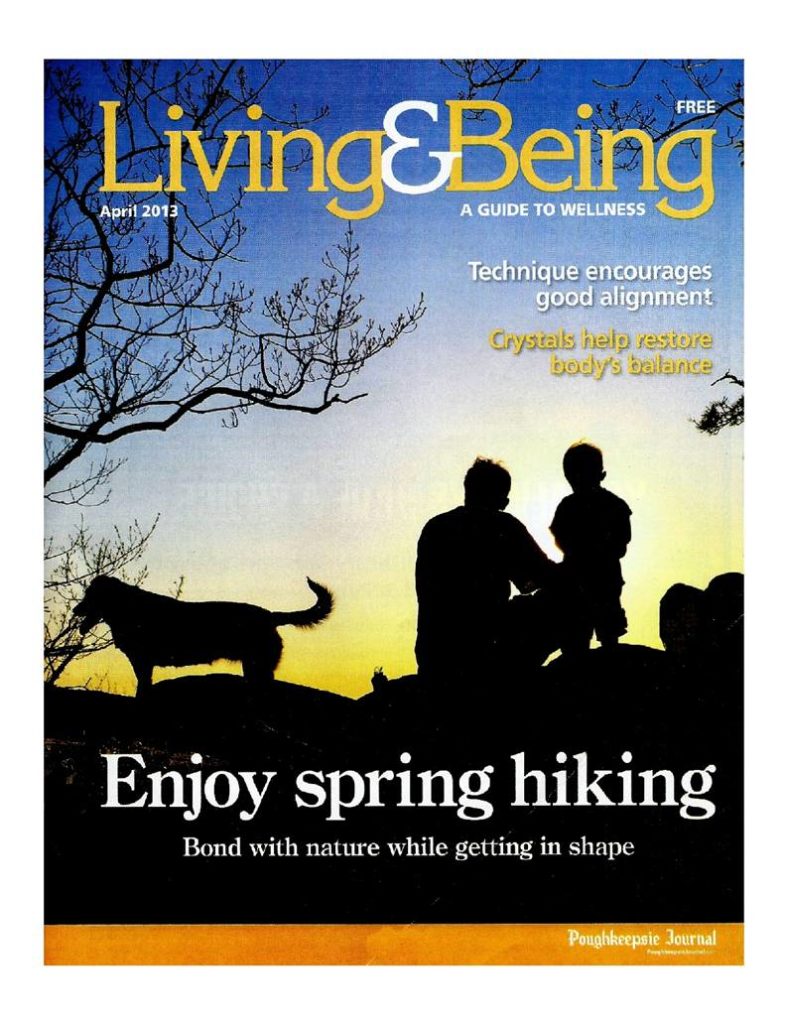
3) Post-processing. I used to think that doing anything to your photos after they came out of your camera was cheating. My buddy Jeff, who is an awesome photographer, explained it to me this way: What comes out of the camera is a rough draft. Don’t go nuts making it look like something it wasn’t – just use some available tools to make the viewer see the image the way you saw it.
The Poughkeepsie Journal used the above image for a local magazine cover. If I hadn’t monkeyed with it in Lightroom, not sure it would have jumped out at them. Now that I’m looking at it, maybe they monkeyed with it some, too? Hey, yeah, their version looks a little more natural. I like it.
The photo editing tools in Picasa are a nice way to get started – Picasa is free and lets you do some pretty cool stuff. After that, you’ll need to drop some dollars on some more industrial-strength software. I use Lightroom (thanks to my awesome wife who gave it to me for my birthday), but I’m pretty much a neophyte just twiddling around with the sliders until it looks hopefully not worse than when I started. For my best shots, I’ll also put them through Nik Software’s Color Efex Pro, which is basically a collection of filters. You can rarely go wrong with the skylight filter for landscapes – nice and subtle. I hear Aperture is a pretty righteous program, too.
Now that I’ve dabbled in some photo post-processing, I’ve come to agree with Jeff. If you’re showing people the images that came directly out of your camera, you’re showing them a rough draft.
Okay, that’s enough out of me. I hope all of this was helpful, Mike! Thanks again for the very kind question.
Anyone else have some good tips, links or gear recommendations? Email them to me and I’ll post ‘em here (giving attribution to you, of course. Unless you give like, really good advice, in which case I’ll pretend it was mine.)
Update 4/28/2013: Thanks to Julian Diamond of Julian Diamond Photography (see Julian’s Facebook page and web site) for offering some more tips! Here’s some goodness from a Facebook comment by Julian:
Just wanted to say your photo discussion is very solid, in my humble, marginally professional opinion! A few broad ideas I agree with: pack light (kit lenses are great for daytime hikes, but I went ahead and bought the Sigma 10-20 too… you can get significantly more terrain in your shots, and it really works to emphasize views. Reasonably cheap, too); don’t get worked up over keeping your final images true-to-sensor, as processing is truly part of the creative process; and 3 or 4 outstanding shots out of 100 is very good in hiking-type conditions. Sure, if I have easy access to a prime location, I have every lens I own with me, and I know what to expect for lighting, I can more-or-less control my results. But out-and-about hiking requires plenty of exposures to produce a handful of nice looking images. The one thing I might suggest to an aspiring trail photographer is to get in the habit of considering your compositions out in the field. Many times I’ve shot an awesome scene, only to get home and kick myself for not including more or less of that tree/rock/creek in the frame. You can’t ever guarantee you’ll be happy with your work, but if it helps you nail one more shot every day, it’s worth putting some thought into every snap.
Update 4/29/2013: More excellent advice from an excellent photographer! Thank you, Michael O’Donnell, for taking the time to share all of this. I hope that people will visit your Facebook page and web site after they’ve read the following excellent tips, which I plan to review again before my next outing:
I could probably write 10,000 words or so but I’ll exercise some restraint and keep it under 9,000.
Gear: Take it slow on gear — the best approach is to simply start with what you have. Shoot with you current gear until you reach some kind of limitation (or limitations), then address those limitations specifically.
The natural assumption when considering “better” photos is an SLR, but in a hiking context you have to consider size and weight. Let’s say you currently shoot with your smartphone or a point-and-shoot and are considering the jump to a big boy. Before buying, try this exercise on your next hike: pick up a nice-sized rock and place it in your bag. For each extra lens you are considering pick up another rock. Add another rock for your tripod. If you’re shedding rocks during your hike an SLR is not for you, at least not for you when hiking. That isn’t mean to discourage. Nothing is more important than being in the right place at the right time so make sure your gear doesn’t get in the way.
I usually carry a full-frame (i.e. large) SLR, wide angle zoom, 50mm prime, 105mm macro lens, filter system, and tripod on my dedicated photo hikes. It’s a lot of gear, but photos are my #1 priority in these cases. If I’m out with the family I’ll just carry the camera with one lens mounted.
Composition: This is it. The most important element and most difficult to master.
Where I see many photos go wrong is a lack of simplicity. Start with a single element: what initially attracted you to the scene. Feature that element. From there add elements that enhance your primary subject and have a reason for every new item you add to the scene. If you don’t know why you’re adding that tree to the scene, keep it out. It’s not always that simple because natural scenes are generally quite chaotic but do your best to keep it simple. Remember that while you are standing there taking in an entire scene with all 5 senses your viewer is engaged, eyes-only, with a 2D medium. Focus their attention.
Next, consider balance. Are the elements, shapes, and lines in your photo in balance? Think of a see-saw — would the left half of your photo balance with the right half (in terms of visual weight)? When asking the balance question think left-right, up-down, and corner-to-corner.
Lastly, the edges! Scan the edges of your frame. Do you have elements touching the edge, awkwardly cut-off, or random branches jutting into the scene? Get them out of there. Keep your edges clean.
Timing: You will read and hear that all good landscape photos are taken at or near sunrise and sunset. I’d love to tell you that is a silly “rule” that is begging to be broken, but, damn, it’s true. The light at those times is simply better, for three primary reasons: the color is superior, the light has direction, and the light is less intense.
It sounds really hard and from a general life perspective, it is. From a photography perspective it’s actually easy. All you have to do is show up. Great light has a way of making great shots obvious. Want to know what is really hard? Make a great shot at 1pm. That takes a masterful level of skill.
Here are the two biggest problems with sunrise/sunset shots: you’ll need a tripod and you may have to hike in the dark.
Settings: Settings for lanscape shots are actually pretty simple, assuming you have a tripod. The tripod simplifies life because it makes shutter speed largely irrelevant. ISO is even simpler: shoot at the lowest ISO your camera offers (usually ISO 100 or 200). When you raise ISO you compromise image quality. That leaves aperture, and ideal aperture is a complex issue, but f/11 will rarely be wrong.
14. Hey, these are all day hikes! What if I wanna sleep on dirt?
One benefit of living in the Hudson Valley is that you can choose between zillions of awesome day hikes, rock one out, then go eat a large pizza, watch some Netflix and collapse in your bed at night, which is generally how I roll. So I’m not an expert on camping in the area, but here are a few helpful pointers:
- The Catskills! You can camp in designated car-camping-type places, or do some backcountry camping almost anywhere. I’ve pointed out some choice camping spots in the guides for Huckleberry Point and Giant Ledge. Mt. Overlook also has some great spots. Here’s some more info on camping in the Catskills:
- Harriman State Park has several shelters – check out the very informative post Harriman State Park Lean-Tos from myharriman.com for more information
- The Appalachian Trail has several shelters in the area. You can find directions to a couple of them in the Cats Rock and Depot Hill trail guides.
- The cabin on Mt. Alander also appears up-for-grabs, though tent camping is not allowed here.
- Almost forgot about Pelton Pond, right off the Taconic Parkway. Plenty of nice spots there. And further north, Lake Taghkanic also has very nice camping and swimming facilities.
- Here’s a nice page for looking up NYS Parks by region.
- Malouf’s Mountain Sunset Campgrounds on Fishkill Ridge near Beacon (discussed in the Lamb’s Hill trail guide), which has some pretty awesome Yelp reviews
- The lean-to near the Beebe Hill fire tower is fair game, and primitive camping is allowed in the forest
If anyone else has some awesome local knowledge they’d like to drop on the rest of us, please do so in the comments below, and I’ll keep updating this answer. Thanks!
15. Can I blast music on my Bluetooth speakers (or any other device) while I hike?
No, it is not safe to do that. Music attracts bears and makes them very angry. The louder the music, the more likely you are to be eaten.* Ear buds are fine, though!
*This is not even remotely true. Can’t hurt to spread the rumor, though!
16. Am I detecting a few more ads on the site?
Indeed you are! Creating and running Hike the Hudson Valley has been the most rewarding hobby I’ve ever attempted, and I would absolutely do it for free. I’d even pay to do it! Which is exactly what I’ve been doing for the past couple of years.
While the site’s original design was created as a favor from a friend, the re-design launched in 2018 (that did many, many wonderful things for the site, including making it mobile-responsive), required an investment. It was worth every penny! But it cost too many pennies to recoup from the loose change people drop on the trail.
Beyond all that, I would love for this site to play a positive role in the hiking community by making regular donations to local trail organizations (like NY-NJ Trail Conference and Scenic Hudson), which is not quite possible to do when the site is making negative money.
Fortunately, Hike the Hudson Valley was recently accepted as a Mediavine partner, which allows me to focus on creating (sometimes!) funny and (often!) accurate trail guides, while Mediavine handles all other aspects of ad placement and revenue generation across the site.
We all hate looking at ads. When those annoying ads start playing while I’m pumping gas, I mash the buttons beside the screen until I find the one that mutes it (there’s always a button that mutes it!). Give me a moment of peace, gas pump. You’re already taking my money! Settle down.
But ads also fund a lot of work that we all value, and that we’re glad we don’t have to pay for. I will continue tweaking the ads here to make them as unobtrusive as possible, and have suppressed ads that were making some of the trail guides difficult to navigate. Otherwise, I thank you for your patience with the ads, which have made a huge difference in the sustainability of this site. Your eyeballs are now directly funding this site’s redesign and my continued work, while also helping to make charitable donations to local awesome trail organizations. THANK YOU!!!
And a special thank you to your retinas, who are the real heroes here.
Do you know the distance of the Bald Hill Loop starting and ending at Dozer junction ? We got to the junction yesterday and didnt know if we had enought time to get all the way around the loop and get down before the sunset.
Thanks!
Hi, Kristina! I’ve never done that loop before, but glancing at the NY-NJ Trail Conference map for the area, it looks like a solid two miles, maybe a little more. Would love to hear from someone who has tried it — worth it? There are six viewpoint stars on that loop, sure looks like it might be a worthwhile addition. You were probably wise to skip it with sunset approaching, but might be a good option for next time.
I’d be curious to know more from someone who has tried it – please drop a comment here if you have!
Thanks for replying! We want to try again with the loop so will mark distance if we get there again before it snows!
You bet – would love to hear how it goes if you get up there!
I’m so appreciative of this website and have been using it for years to choose hikes to try! Do you accept recommendations for hikes to check out? I’ve done a few recently that I didn’t see here- but I think they would be great additions!
Thank you so much, Mary! Absolutely, I’ve found some of my favorite hikes that way, including many of those documented here. Would love to hear your recommendations!
Check out the Pawling Nature Reserve- I believe there are a few different trails within it!
Thank you, Mary! If there’s a certain destination or trail that you recommend in the reserve, please let me know. Appreciate you reaching out and sharing!
I think there are two ways to enter- but entering at Quaker lake road by French lake you will see a little boardwalk and then following the blue trail you will come to an open field with a pretty view – I think these might be accessible from the other trails too but I’m not certain.
https://www.nature.org/en-us/get-involved/how-to-help/places-we-protect/eastern-pawling-nature-reserve/
What a nice photo! Thanks for sharing it here, Mary, along with the helpful link — looks like a great spot!
Are you on All Trails? Places there isn’t service will not allow me to use this site while hiking.
Kourtney, your comment got me thinking about ways I might be able to integrate Alltrails functionality into my existing trail guides. (Turns out I do have an Alltrails account, and had somehow already uploaded 60 GPS files there, though I have no recollection of doing so. Maybe I went on an all-night uploading bender several years ago?) In any event, I added an Alltrails widget and link (that will open in the Alltrails app on a mobile device) to a trace of my hike in the “Resources” section of the Beebe Hill hike, right under the Google Map and Youtube video: https://hikethehudsonvalley.com/hikes/beebe-hill-fire-tower/.
Would this help solve the problem you’re experiencing out there? If so, I could roll out something similar on most of the trail guides across the site. Thanks so much for the thought – this could be a nice addition to the site!
I download the site to my phone at home, while I still have service.
Have you considered putting a book together? I could see it as a large coffee table book with all of your beautiful pictures, or as a trail guide. Perhaps something in the middle, or even both! Just a thought, I’ve loved your site since I found it a few years ago, and I know I would buy one.
Ben, what a flattering suggestion! Thank you so much! I have so much I want to do with improving and adding to this site that I’m not sure when I’d find time to turn my attention to a book, but it’s really nice to hear that someone besides my mom would buy one. Maybe one of these days! Your encouragement is very much appreciated, thank you.
Hey Mike! I have been using your site for nearly 4 years now and over that time I have seen so much more of NY state than I ever would have otherwise. I have managed to spend so much quality time out in the mountains, enjoying nature and it has been not just fun but often times therapeutic. Around 9 years ago now I lost my dad, who was also an avid hiker, mountain climber, and outdoorsman and through these hikes I get to honor his memory by doing something that he and I used to do together. I hope you know that your site is so much bigger and more meaningful than just trail guides. Especially to me.
I just wanted to take a moment to thank you for creating this website and for taking countless hours to put together these guides, amend the directions along the way, and keep us hikers current on trail status/conditions/parking/etc. I can’t even recall how I first found your site but I use it like my personal hiking bible and I am so thankful for the content you’ve put out.
With sincere thanks, your friend from NJ,
-Chris
Chris, this is one of the most meaningful comments I’ve ever received here, just got a little misty reading over it again. Thanks so much for taking the time to share your experiences, so glad to hear this site has been helpful to you in exploring the area and honoring your father’s memory. Loving to hike is a gift my dad gave to me as well, and one I’ve been doing my best to give to my own sons (it looks like it might stick, time will tell). Your thoughtful feedback here is so very much appreciated. Best wishes to you in all your future exploring, and here’s wishing you many more happy memories to go with the ones you and your dad collected together.
We went up to Popolopon Torne this weekend. Too icey to do without crampons. (Didn’t stop the woman who strode by us however!)
BUT… A GIANT thank you to you. Your hikes are so wonderful, and the specifics always keep me secure that I’m on track. I adore your site and can’t thank you enough for the labor you’ve put into it. During a rough patch a couple years ago relied immensely on your hikes. Abrazos–Long Life and Long Hiking to you.
Carol, this comment absolutely made my day today. Thank you so much for the kind words! Here’s to many more adventures for you as well!
It seems like some hikes have been remove (Mt. Tremper). What happened? I like rattlesnakes.
Hi Kelly! They should all still be there! I haven’t written up Mt. Tremper yet, but it is still on my Coming Soon(ish) list. Sounds like that is indeed a good place to make more rattlesnake friends – I hope to give it a visit (during cold, non-rattlesnakey weather) and write it up in 2019. Let me know if you find any trail guides that are missing, or recommendations for ones I haven’t written up yet. Thanks for checking in!
Thank you! I’ve been using this site for several years now, on almost every trip I take upstate from the city. This site should be national. I have never encountered a more thorough and comprehensive hiking guide. Nothing against books, but why am I still flipping through books to find hikes when I go to national parks? Mike, isn’t it time to take this site national and put the hiking guide publishers out of business? I want them out on their asses!
Really, though, this site is above and beyond what it needs to be to keep me coming back. I’ve explored so many more places that I would have without it and intend to explore a few new ones this weekend. Thank you.
Thank YOU for the kind words and the laughs, Benjamin! It’s really gratifying to hear, and I’ll do my best to keep the trail guides coming. Here’s to many more adventures out there!
I am a coordinator for a Westchester Meetup group and am always looking for new activities. We’re not a hiking group, so the difficulty ratings are very helpful as are the scenery ratings. I don’t want to be shunned by the group if they don’t think the hike was worth the effort. It’s not easy being me. Anyway, what would be super helpful is if you would post the town in which the hike is in so I can factor driving distance into my complex algorithm. Woodja couldja? For me?
Thank you in advance,
Truly and sincerely,
Your humble servant,
DG
Diane, that’s a great question! I originally set “The Hikes” page up with the town names listed in one of the columns, but it was too ungainly, and I had to trim that column out for the rest of the information to fit on one screen. The best way to plot the hikes by location is to use the site’s Google Map. You can also see the town name listed on each individual trail guide in the “Directions” section, where the address (or a nearby address) is given. I hope this helps, and wish you all the best in your planning endeavors!
I am a coordinator for a Westchester Meetup group and am always looking for new activities. We’re not a hiking group, so the difficulty ratings are very helpful as are the scenery ratings. I don’t want to be shunned by the group if they don’t think the hike was worth the effort. It’s not easy being me. Anyway, what would be super helpful is if you would post the town in which the hike is in so I can factor driving distance into my complex algorithm. Woodja couldja? For me?
Thank you in advance,
Truly and sincerely,
Your humble servant,
DG
I realize this is not something you want to hear, but perhaps it will give you some thought..
You may feel like you are doing a good thing for people and from many people’s point of view you are, but there is another side to all of this. I live near one of the places that unfortunately appared on this site. Prior to that it was a very quiet place where one could find solitude, basically have an experience of being in nature. Once it become popular, most likely due to this site, it started getting more and more people, the trails that weren’t meant to sustain much traffic erroded to the point where they had to be closed and rebuilt by the park, trash was everywhere, water bottles, bagged dog poop(??), human poop, toilet paper… The parking area went from having 1-2 cars to being full most of the time. The place that I used to value and enjoy no longer exists, thanks to you. Yes, I understand it’s nice for people from the city to go for a hike.. but many visitors (not all of course, but MANY) don’t particularly value the places they visit. They don’t care what impact they have on it.. they perhaps are just looking for a tick mark, (a patch or a sticker??) to add to the list of places they’ve been to and a picture to show their friends.
I am not attempting to discourage people from hiking.. I’ve done a lot of hiking in many places, but I typically just pick something off a map. Sometimes the hikes are awesome, sometimes not.. but the experience of going to places without quite knowing what you’re going to find and to places that are NOT crowded.. it’s worth a lot.. There is nothing cooler than finding a spot that is very scenic, empty, and that you didn’t know existed!! (and then NOT telling the world about it after so that perhaps they can discover it on their own). Perhaps this is just where this world is going, and I’m sure most people here will disagree with me, but please understand the impact (crowds, trash, erosion, impact to wildlife) that YOU have on these places that you claim to love..
Please consider not adding more hikes to this site and at least save some of the places from being choked by the crowds..
An article posted just yesterday on this very topic concerning national parks, but may as well apply to many areas in the hudson valley:
https://www.theguardian.com/environment/2018/nov/20/national-parks-america-overcrowding-crisis-tourism-visitation-solutions
JL you certainly have some valid points and I feel your pain. But blaming Mike and his site isn’t fair. He strongly advocates for people to pick up trash and to leave trails cleaner than you found them. Hiking in general has been suffering from this fate recently. It happens when once hidden trails gain popularity. I have been to trails a few days after Mike listed them and they were already dirty. I can only speak for myself, but I walk out with as much trash as I can carry. I usually hike on Mondays. If a trailhead appears overcrowded, I change my plans. I’m sorry your favorite local spot has encountered some less than courteous hikers and thanks for sharing. But Mike’s site is also inspiring people to become trail stewards and take care of their trails. I urge him to continue.
I’m not as much “blaming” him (I apologize if I sounded that way) as I am trying to say that there is another darker side to all of this. I have absolutely no doubt that Mike has the best of intentions, but I also think we live in a different world from when this site started originally. I myself once took a friend on a trail in the Catskills only to discover to my horror that he started bringing meetup groups consisting of literally dozens of people there weekend after weekend.
It may be difficult for a visitor to appreciate an impact they have on a spot if they don’t get to witness it change throughout the years. I’m not just talking about garbage, but things like crowds and erosion — no matter how careful you are you will contribute to those things (that obviously includes myself as well). And again, I’m not discouraging people from hiking, but I think we need to find balance here.. certain places can handle much larger amounts of traffic due to the presence of carriage roads for example. I understand that some people who are new to hiking and are just looking for any sort of suggestions may greatly benefit from this site, why not direct them to the spots which can handle it? Once they get a little more comfortable, they can get NY/NJ trail map and go explore. It’s as simple as that. I’m not stopping anyone from going anywhere, but please understand that by advertising any remote/quiet spot, you are essentially destroying that most import aspect of it. I understand everyone wants to get away from the crowds, but by giving the crowds directions on how to avoid crowds, all we’re doing is making sure that every place in the vicinity is crowded..
All it takes is one person like my friend or someone who geotags an instragram picture and a place is never the same. Here’s an article about blue hole you are likely familiar with https://www.nytimes.com/2017/08/20/nyregion/blue-hole-swimming-catskills.html … there are likely many thousands of stories like that in the US.
Again, the world we live in is very different from what it was. Things that end up on the internet often cannot be taken back and come with unforeseen consequences. All I ask is that you consider this other side of things.
Yeah I get it, it’s a difficult balance to maintain. I hike to get away from people and that’s why I’ve been avoiding places like Breakneck Ridge. I much prefer to hit the adjacent Bull Hill early on a Monday morning when no one is there. I’m lucky in that I work every other weekend, so I have every other Monday and Friday off. I’ve yet to find a hiking spot that’s crowded on a Monday morning. I also know that I have several small go-to spots locally that like you said, don’t appear here or on any of the high traffic blogs. Yes they’re listed at NYNJTC, but you really have to look hard to find them. I’m not sure what the answer is, but Mike limiting his scope probably isn’t one of them. Raising awareness probably is. Maybe organizing a regular clean-up day at your local trail. Sucks that you have to even think that way, but sometimes it’s good to rally the locals to protect what’s theirs.
JL, I appreciate you stopping by to voice your concerns here and in the Stony Kill Falls trail guide, and understand and empathize with the points you raise. I think this topic deserves a thoughtful response, and will spend some time on it in the coming week or two. (And thank you, Jeff Kent, for your kind words.) More to follow…
I felt like I needed to reply. I have lived here for 10 years and have not known the beauty of what was around me until I stumbled upon this site. I am overweight and out of shape and have been looking for something to motivate me to get out there and make me a better person. I can honestly say that finding this site and realizing that there was so much undiscovered beauty (at least for me) out there that it motivates me to go hiking and see what there was out there that nature had to offer. I have since been hiking as often as I could and have lost over 30 pounds since I began thanks to this site. But I totally understand the original posters concerns. I enjoy hiking Breakneck Ridge but refuse to hike it on a weekend because of how crowded it can become due to the added traffic from the train that stops there. So I guess what I am trying to get at is that it is all a double edged sword. For every person that Mike is helping by opening their eyes to the beauty that is all around them but never knew how to enjoy, there is an equal if not more number of people out there who will over abuse the information he is giving in order to enjoy those same hikes without giving back to nature. At the end of it all, it is the responsibility of the end user to determine how to use the information he is giving. I personally have been using it for the best. So if there are people out there who have been using that information for ill intentions, I personally can’t seem to blame Mike (or anyone else for that matter) for that. I hope that helps. Thank you.
Jason, I completely understand that this site is very useful to a lot of people. As I mentioned in another comment above.. garbage is just one aspect of things, one symptom of overcrowding. Hiking has drastically gained in popularity in the recent years. I would say the increase is significant even from last year. This is true in many places in the US, so I’m not blaming this site for this.. if Mike didn’t create one, I suspect someone else probably would’ve. Anyway.. what I’m asking is that we stop adding things to the list, so that at least some areas stay relatively quiet, so that hikers in the future have some small chance to visit places where trails haven’t become eroded, where the parking lots are not full, where you don’t see dozens or hundreds of people. They won’t be the best trails, but they will be special, just because they are not crowded.
Hi! I love your website!
It would be great if you could also add some information on whether it’s possible to reach any of those hikes without a car!
Is Breakneck open this weekend 9/22/18?
Hi Ally — the rumors of Breakneck’s closure were premature. It remains open for the foreseeable future, and I’ll do my best to keep that trail guide updated with the most current information. Happy adventuring out there!
Hi. Mike.
Just wonder where is the place for the most beautiful on the front page Picture (THE HIKES).
Love your hiking blog, it becomes the classic tour guide for us.
Thanks a lot.
Jian
Mike, I love your site! I’m a landscape photographer (amateur), so I was digging the photos, but got into your writing, too. Funny stuff! Just wondering if you could tell me where the banner pano on The Hikes page was taken? Stunning view. Thanks for all your work.
Hi Matt! Thanks so much for the kind words! Absolutely, that photo was taken at Wittenberg Mountain. https://hikethehudsonvalley.com/hikes/wittenberg-mountain/
Hey Mike,
I love your site and have found it so useful in planning my hikes over the past few years. I am looking for a special hike in the Northern Catskills to scatter my father’s ashes (I was thinking Windham or Hunter) next week. I was hoping you had a suggestion for a dramatic, scenic route. I will be staying in Durham, NY but am happy to travel up to 45 mins for the trail. I am not very familiar with the Northern Catskills so I hoped you would have some suggestions.
Thank you!
Julia
Julia,
Condolences on the loss of the father – so sorry to hear it. I haven’t been to Windham, but Hunter Mountain (http://hikethehudsonvalley.com/hunter-mountain/) is a gorgeous hike — only limited views until the top, but a wonderful trail the whole way up. I documented the shortest, steepest route in my trail guide, but there are links there to other trail guides that give you a longer, less steep route. There’s also a quieter overlook on Hunter, near the tower, documented in the trail guide (Step 15). Another option could be Indian Head & Twin Mountains – the view on Twin Mountain is amazing, no fire tower required (http://hikethehudsonvalley.com/the-hikes/indian-head-mt-and-twin-mt/). I’m sure there are other beautiful spots nearby, but these are the ones I’m familiar with. Hope this information helps – best wishes to you and your family, and I hope you find what you’re looking for next week.
Hi! My husband and I love your site and are always looking for more long challenging day hikes and hikes with great views. Our favorites so far on your web site are Indian Head / Twin Mountain and then Wittenberg. Is there an equivalent guide to you in The Adirondacks?
Thanks!
Mike — I’m attempting to view the Kaaterskill Falls II (upper falls) hike. I’m using an MacBook Air with Safari… the page reloads about 3 times and then I get an error message saying that an error repeatedly occurred with the page and I am given the choice to reload again .. (and again it goes through the same things and then doesn’t load).
Hi Paul — the same thing was happening on my own Mac, and I’m surprised nobody else has complained about it until now (I was foolishly hoping I was the only one running into it). I believe the problem is with Flash, specifically the Flash player that plays the Flickr slideshow at the bottom of the page. If you’re up for the hassle, you should be able to disable Flash for Safari — directions can be found here. I’m working with Kingston Creative to launch a new version of the site, which should be ready relatively soon (days or weeks). That new version will also fix the problem. Thanks for reporting the issue, sorry for the hassle!
More of a suggestion than a comment. It seems to me that a lot of people, myself included, started or got back into hiking by following the hikes on this site. While it is an amazing feeling to have completed a hike ad thoroughly enjoyed it, I understand that some people gain even further satisfaction from completing an achievement. Personally, I am 10 hikes away from completing everything you’ve listed here, and while I don’t necessarily need a certificate, a patch would be a nice way to show what I’ve done. However, of all the items listed in the shop, patches don’t appear to be there. Just some ideas to consider, I hope you’ll give it some thought and perhaps I’ll see a reply sometime soon. Thanks for this site and everything you’re doing.
How about some of these snazzy new stickers?
https://www.kickstarter.com/projects/5463674/hike-the-hudson-valley-shirts-hoodies-and-stickers
It’s just not the same. Hikers and patches go together. It is how it is.
Tristan — Wow, only ten hikes left? I better get cracking on some new write-ups! Congrats on knocking out so many awesome hikes. You’re not the first person to request a cool patch, and I appreciate the suggestion. I’ll be partnering more with Kingston Creative soon, and they have expressed an interest in designing some cool patches. We will fire something up soon(ish)! What should the accomplishment be? Maybe a Hike the Hudson Valley Whole Thing Doer? We’ll figure something out. Happy adventuring in the meantime!
Hey Mike. You helped me out almost 4 years ago (where has the time gone) when I was trying to decide on what kind of pack to get for hiking with my son (http://hikethehudsonvalley.com/frequently-asked-questions/#comment-1370). Well, I’m going to need your help again. My wife just gave birth to twins in December and I’ve been wondering if they make any hiking carriers for 2 kids at once. The closest thing I could find is where their legs are dangling like a baby Bjorn. My son didn’t really like that when I started hiking with him and he enjoyed it more when I got one where he could rest his feet in. The closest I could find was someone posting a picture of using 2 carriers. One like the hiking carrier that I already have in back and another carrier like a baby Bjorn where their feet dangle in front. If that’s the best I’m going to get then I guess I’ll just have to have them take turns which one is in the front and which one is in the back.
Have you ever tried hiking with 2 kids on you? Do you know of anyone who has? Do you have any good advice or know of any better sites that specifically talk about this kind of thing. Thank you.
Hey, Jason! My kids are three years apart, so my oldest got booted out of the hiking pack and had to fend for himself after his little brother came along. I did try carrying them both very briefly, with a Kelty pack in the back with a Baby Bjorn in the front — photo attached — but it wasn’t a tenable situation. You’re a champ for trying to figure something out here! I will reach out to someone who runs a hiking group for moms and see if she can offer any advice. Best of luck! And post some photos if you do work it out!
Lol. Thanks. What you did in your photo was the closest thing I could find. What I was hoping til find was a pack that could fit 2 kids next top each other in the back but I don’t think one like that exists. I appreciate you reaching out to that moms hiking group for advice. Thanks.
Just wondering how much snow there is on the peaks East of the Hudson ? Do I need snow shoes or just micro spikes ? Esp interested in Mt Beacon. Coming in from Connecticut ..
TIA
Hi, Peter! A hearty hiker just messaged me a picture from the top of Breakneck (one peak over from Mt. Beacon) on Saturday. This picture is probably more useful than anything I could tell you. Looks like he went with spikes and gaiters. Hope this helps – good luck out there! (And thanks for the image, Christopher Pelaia!)
Thanks Mike. Just what i was looking for. Now it looks like we’re in for some white stuff. Hope u have a great hiking year. Looking forward to the hudson eastern peaks.
Are you open year round
Hi Sharon — I am sort of open year-round, in that I am a dude with a website, and that website is open all the time. If you’re looking for information on any particular trails in the area (most of them are open year-round), please post it here (or on the corresponding trail guide), and we’ll try to get some current information headed your way. Stay warm out there!
Hey! Kent Falls in Kent CT which is about ten minutes from where I live in Amenia NY is a nice small hike to add to your list!
I can vouch that Kent Falls is worth adding to the list.
Hey Mike – first of all thanks for this amazing resource! Great info and an inspiring todo list 🙂 I was wondering if you know of a similar resource for backcountry skiing? Or which of these hikes you have listed here have good options for some downhill when we get enough white fluffy stuff. Thanks!
Hi, Daniela! I’m afraid I’ve only tried to go skiing once since I’ve lived in the Hudson Valley, and didn’t realize the mountain was closed for the day until we rolled into the parking lot. So I’m 0 for 1 to date. If you have tracked down a good resource, I’m sure other folks would be interested to see it. Sorry I’m not more help!
Hi! First, I love your site! I’ve used it a bunch when researching a bunch of hikes I went on last summer. Unfortunately, I am a lover of the full-day hike (8+ miles) and hater of camping; thus I’ve had to branch out from the meager trails of Stamford, CT for better and longer hikes!
But, my question is—given that I am driving 1.5–2 hours for these hikes—do you have any tips on how to read the weather to see if it’ll be worth it? I.e., I don’t want to drive so far and get to top and not be able to see anything. Obviously, if it’s heavily forecasted for rain, it’s a no-go for me. I’m in it for the workout and the view! I’ve been really lucky so far and have had great views on all my hikes.
Just wondering if there were any key things to look at to make my decision! Thanks so much for your time!
Mike always lists the weather for the hike area, but if you want a second opinion these guys are excellent.
http://www.hudsonvalleyweather.com
Hi Sarah! I’d have to second Jeff’s advice on the Hudson Valley Weather guys — they give the most detailed, accurate forecasts for the area. Otherwise, looking for low humidity will help — very humid, hazy days can squelch a good view. Some of the best views happen on days where the clouds just happen to break the right way at the right time, and you can’t really plan for that other than just to put yourself in the right place enough times that you get lucky every now and again. Sounds like you’re already doing that — hope you continue having some great adventures and some great views out there!
Hi Mike,
I hope you’re well. I was wondering if there’s anyway to separate available hikes for public transport users?
I’m obsessed with you and your blog and want to use you as a guide but I live in NYC without a car or access to one most of the time.
Please let me know if there’s anyway you could sort out some hikes you know I could get to without getting lost transferring between the metro-north and busses?
I would be so grateful.
Best,
Chelsea
Hey, Chelsea! Thanks so much for the kind words. I’ve gotten this question fairly often, and I’m afraid I’m just not a very good resource on public transportation options to most of these hikes because I always just drive to the trailhead. I tried to get something going in the now-defunct Forum a while back: http://hikethehudsonvalley.com/forum/hiking-without-wheels/. But that’s, you know, now-defunct.
One thought that your comment has sparked — what if I created a page on the main nav (right next to “Leave no trace”) called “Have no car”? People could leave tips and comments when they discover a good way to get to a trailhead via public transit, then I could update the corresponding trail guide(s) with that information. Think that would help at all?
Mike,
Yes! That would be so helpful.
I really want to hike as many of these as I can, but not having a car makes it difficult to plan.
I’m trying to get a friend who is a friend of heights into hiking. Is there a hike that you’d recommend. She’s very sporty and capable, just can’t be scrambling over rocks or looking over a cliff.
Hi there! Maybe Bull Hill? That’s a very nice hike with views and no cliffs. Huckleberry Point, Rand’s View, Black Rock Forest, Constitution Marsh, and Bash Bish Falls would all be good choices, too. Hope that helps, and I hope you have some nice hikes with your favorite acrophobic adventurer!
Hi Mike,
Thank you so much for the great hiking resource.
I wonder what app/GPS do you use to create the Google Terrain Map of hike route.
Thanks,
Hi Will,
Thanks for the kind words! I use a Garmin eTrex to gather the data and mark waypoints while I’m on the hike. The file that comes out of the device is in GDB format. I use the Garmin Basecamp program (it’s free) to make minor adjustments (like renaming waypoints), then export the file in KML format. Google Maps lets you import that KML file to create the new map, then you can adjust settings in Google Maps from there to make the map look the way you want (show waypoint labels, pick the color and width of your track line, choose Terrain Map as the background, etc.). It took a fair amount of twiddling around in Google Maps to get them looking right, but now it’s pretty quick — let me know if you have any issues if you give it a whirl. Hope that helps!
Hi! It is entirely possible that I don’t know where to look, but all the info I can find online about winter hikes in this area are for less-intrepid, possibly kid-laden people. I’ve got the appropriate gear and the will to do something a bit more ambitious, even/especially in the snow, but would appreciate some guidance and recommendations.
Thanks!
Hi Sarah! Yeah, I’m reluctant to give advice on winter hiking, in part because I don’t do that much of it myself, and in part because I’d feel really bad if someone turned up 10,000 years later in a block of ice because they followed my advice. If you’re up for tackling some serious winter hikes with other intrepid cool people, I’d recommend both of these groups: http://catskill-3500-club.org/schedule.php and https://www.meetup.com/hvhikers/. Hope that’s helpful!
Thank you, Mike! This site is great!
Hello everyone! What’s a good hike during this time of the year? I am trying to go the last week of December….
Hi! I really appreciate your write-ups! I moved to Poughkeepsie area a year ago and have done probably 6 hikes off your page. 🙂 you may be interested to know that Scenic Hudson just (October 2016) opened a new park in the Esopus area – High Banks Preserve. I haven’t hiked it yet but I hear its 3 miles of trails are pretty great!
http://www.scenichudson.org/parks/highbanks
(full disclosure, I work for Scenic Hudson, but not in the Parks division)
Thanks so much, Alicia! I visited that site with my sons on its opening weekend, and I will absolutely write it up (most likely over the winter – I have a couple other write-ups already in the queue). Thanks for all the great work from you and your colleagues at Scenic Hudson – you all make the Hudson Valley a better place to live (and explore)!
Hi Mike – I was wondering where YOU might suggest hiking (after dark) to see the November Supermoon rise on Sunday the 13th. I have a hiking Meetup and would very much like to put a group hike together to witness this “largest appearing moon that won’t happen again until 2034”.
Preferably somewhere that is on the easier side, don’t want to rock scramble in the dark.
Thanks!
Jamie
I know you were asking Mike but I figured I would chime in here. When there was the super moon and total lunar eclipse happening at the same time (I think that was last year or the year before) I watched it from the Mount Beacon Fire Tower and the view was great. And you don’t have to go all the way to the fire tower either. There is a big open area at the top that is just as good to watch from. The fire tower is about another 20 minutes from that point and does have a bit of a increase in difficulty once you get almost to the fire tower.
I also went with a group from Meetup.com so I wasn’t hiking alone. They were very friendly and everyone looked out for one another both up and down. They are doing another hike to the tower for the super moon on Sunday. If interested, you can check out the event here http://meetu.ps/e/C9qpb/gS8cs/d The meet up says full but if you just show up I’m sure you will be able to catch up with someone to hike with you. You could alternately just check out Mike”s writeup on the Mount Beacon hike and follow his guide. Hope this helps.
Thanks for the great suggestion, Jason! Another good spot would be Mt. Overlook (though it is a tough hike) — it’s a gorgeous overlook, and the hike back down is mostly on a wide gravel road, so not so many roots and rocks to worry about. I watched a moonrise from there many years ago, and it still sticks with me. We barely needed the flashlights on the hike down, and turned them off entirely for much of it. Hope this helps, Jamie – enjoy the supermoon!
HELP!
I hiked Mt Beacon 2 wks ago & took a map/pamphlet. It shows a parking lot by Sunnyside Rd where you can hike the Overlook Trail & stop at Fishkill Ridge Trail & go back or continue on it or up to Lams Hill… Why cant I find any info on just doing Overlook Trail from Sunnyside Rd to maybe Fishkill ? How many miles? Is it steep or???
Also if I did want to do Fishkill Ridge Trail where is parking?
I am looking for a little challenge -nothing more difficult than Mt Beacon Casino Trail to Fire Tower & nothing over about 4 miles….. Any info would be much appreciated! THANKS
Hi there, Helene! Check out this trail guide and let me know if it doesn’t help — it documents climbing Fishkill Ridge from the Sunnyside Rd parking area: http://hikethehudsonvalley.com/the-hikes/fishkill-ridge-lambs-hill/
So glad I found this site! Is there any possibilities of actually becoming a member to this sites so that users can receive alerts/update emails?
Hi, Michelle! Thanks so much! Whenever I add a trail guide, I update the site’s Facebook page, which is probably the best place to keep up with news related to this site: https://www.facebook.com/HikeTheHudsonValley
Let me know if that doesn’t do the trick!
Hi Mike! I’m looking for a hike with sweeping views of the hudson valley for a family, but that are not to far from the town of Hudson.
Any recommendations?
Thanks a lot in advance 🙂
Agathe
I hear Harrier Hill is a nice family-friendly hike, though I’ve never been there. Olana also has beautiful views of the river and some nice hiking trails, which are on my list to explore one of these days. Hope that helps!
Just hiked Schunemunk with your trail guide in my hand. Many thanks!
This was our second mountain in our families new addiction, we did French Mountain in Lake George in August.
We’re hoping to hike Slide mountain next month, but you didn’t give us an excellent trail guide yet!!!
What guide will you follow when you get to Slide?
The Kench family
Long Island, NY
Thank you so much, Hal! (Great shot, too.) Slide is on my list, but the views are apparently pretty overgrown, so it hasn’t been my highest priority. I just did Hunter Mountain via Becker Hollow last week, and it was amazing. I’ll work on the guide for it over the winter. As for Slide, this is the route I would try: http://catskillmountaineer.com/SMW-slide.html
Happy trails to you and your family!
Mike
Hi Mike!
I just found your website and this is awesome. Thank You! We have a 6 month old puppy that literally looks just like yours from what I can tell in photos (but he’s already almost 50 pounds, so maybe a little bigger). I’m going through the different hikes you’ve been on (I originally came for breakneck but worried about the climbing with him – some of those looked crazy steep on the climbs, and he’s hard to lift while balancing). We’ve done a few hikes already, in the 5-6 mile range over on the Harriman side, but won’t have a car this weekend. Do you have a hike you can recommend from mass transit I can look at that we’d be able to do with the dog (He’s a better hiker than me, so it can go difficult, but maybe not high vertical climbs)?
Thanks,
Kelly
Hi Kelly! Sounds like a great pooch you’ve got there. I’m afraid I’m not much help when it comes to mass transit – perhaps a stroll from the Cold Spring station to Bull Hill and Little Stony Point? It adds some distance, but should be doable. This article is a good resource, too: Top Summer Hikes for Car-Free New Yorkers
Hope that helps!
Hey Mike,
I have been using your guides to determine which new locations to hike. I have already went to 4 locations this year and I absolutely loved the Monhonk Mountain House/Labyrinth/Lemon Squeeze.
Just want to thank you for doing this for everyone else to enjoy
Thanks so much, Oscar! Hope you’re continuing to have some great adventures out there.
Awesome site, thanks for sharing. Any places good to fly drones for photography?
Thanks, Eduardo! I’ve never flown a drone before, but assuming they can be flown without buzzing so much that they ruin everyone else’s natural buzz, I think any of these hikes would have cool and unique views to explore aerially.
I was at a crowded Bear Mt. this summer when two guys had their drone flying. It was equal parts cool and distracting. My advice would be to keep the flight short if there are a lot of people around. Because even those of us who thought It was cool got tired of the loud buzzing. If no one’s around, let it fly. Anthony’s nose would probably be pretty interesting with the river and bridge. Schunemunk would also be impressive, to see the monoliths from the air.
Love your site! Thank you for taking the time to share your adventures.
Do you know of an app to that tracks actual miles traveled on hike with heavy elevation changes? My apps seem to only track satellite miles…2D miles.
Coming down the Casino trail from the fire tower to Beacon, other hikers claimed it was a 4-4.5 mile hike up. My app tracked it at 1.6 miles one-way. I had just hiked over to the fire tower from the Breakneck trail head in Cold Spring and when asked, told them I traveled 4.7 miles, according to the app.
Planning to hike from Cold Spring to Beacon and back via the Breakneck, Wilkinson, Casino, Fishkill, and Notch trails. I would really love to get more accurate distance data. I’ve been told to buy a pedometer. Do you have any suggestions?
Hi Shadow! I use a Garmin eTrex Vista HCx that I got in 2011 (so it’s probably long obsolete), and it’s how I gather all the distance/altitude data I put in these guides. It’s not always exactly on the money, but it seems to give pretty reliable numbers. There are many similar models now that would most likely be useful to you as well. If you’re looking for accurate stats, picking up a hiking GPS would be a good investment — I’ve enjoyed having this one. Hope that helps!
Mike
Your site is what got me into hiking almost 2 years ago and now I want to try and see if I can complete the Catskill 3500. I see you have done writeups on a few of those mountains. Do you plan on doing more? Is there a way for you to mark up the ones you’ve already done with some kind of symbol next to them to better help me find the hikes that are part of that club rather than me jumping back and forth between your page and the official least? Or is there a better site out there that is like yours that only focuses on those hikes and would be better for me to use instead? Have you yourself competed the Catskill 3500 and if so what advice can you give for someone who is thinking about trying it themselves? And if you haven’t yet, are you looking for a buddy? 😉 Thanks.
Thanks so much the nice comment, Jason! I only have a handful of the 3500′ peaks documented on this site: Wittenberg, Panther, Overlook, Indian Head & Twin, and, dang, is that it? I better get cracking! Sigh, I just checked, and Overlook isn’t even one of them. Sorry to be so lame.
I actually work with a former president of the Catskill 3500 Club, and I asked him what resources he’d recommend. He pointed me to the homepage: http://www.catskill-3500-club.org/
He also told me that they try to do volunteer-led hikes to each of the 3500′ peaks every quarter! I had no idea. From their homepage, you can download one free copy of their newsletter, The Canister. In that newsletter, you’ll find a schedule with a TON of guided hikes. Sounds like you’re an aspirant now — good luck becoming a member!
Well I’m not an aspirant until I officially register to be one which I am going to do soon. Thanks for the website. Although after much searching I came across that one myself. I just love your guides so much and had hoped you had done more or were planning to do more soon in the Catskills. I guess I’ll have to register for the canister and hop on to those guide hikes then.
I do plan to keep chipping away at them, but it will be a while before I can get any more of them documented. Really glad to hear that my guides have been useful for you, and I’ll try to bump some more 3500′ hikes onto the list this year. Thanks for the motivation!
Hi there.
I just wanted to say THANK YOU SO MUCH. I grew up in NH and now live in NYC and miss having off the beaten path hikes to go on that I know of and can actually get to in a day. I hiked Rands View and honestly it was one of the best hikes I have done in years and years. You really made my day (and my dogs!) and I just want to let you know that this website truly is such a gem, thanks for sharing the beauty of the Hudson Valley with the larger world and trusting that those of us who hike it will take care of it.
All the best,
Rebekah
I just came back and read this comment again and it made my day all over again. Thanks so much, Rebekah!
i did breakneck ridge baby
What are your recommendations for trails with waterfalls?
Hi Ron – I’d check out “The Hikes” page and search on “waterfall” — if the description has the word “honking” or “huge” in it, that’s probably a good one to start with. Plenty of great options, though you might find them starting to slow down to a relative trickle at this time of year, unless you can visit after a good rainfall. Hope that helps – happy adventuring! http://hikethehudsonvalley.com/the-hikes/
It is great that you love the outdoors and are encouraging others to get out side as well. Please be aware that all Scenic Hudson parks have a dog on leash policy as do virtually all state parks.
http://www.scenichudson.org/parks/parkinfo/dogpolicy
-Steve
Hi!
I love your website, there’s so much information, and I like how “casually,” “user-friendly” everything is written. Very down to earth, a pleasure to read through.
I’m looking to book a weekend upstate, we live on Long Island, for my boyfriend’s birthday. We went for a “hike” last weekend in Suffolk County. I thought a weekend upstate “hiking” would be nice. I use ” ” around hiking bc we’re not looking to go rock climbing or anything dangerous.
I was hoping you could suggest a trail for us. Here’s what I’m looking for:
A train that is mild in difficulty, I’ve only gone hiking twice — once was last weekend, the 1st time was in a rainforest in Puerto Rico…which was more of a stroll.
I’m starting to get more into photography — so scenic is ideal, maybe a waterfall. I’d love to snap some great shots.
Not be more than 30-40mins from our hotel/resort
Any feedback you can provide me would be great!! Thank you!
Hi Michelle – so sorry for the late response here! I’d recommend perusing “The Hikes” page (http://hikethehudsonvalley.com/the-hikes/) and checking out all of the hikes with five-camera scenery ratings. You can’t go wrong with any of them. Choose one with the difficulty level you’re looking for and/or the right proximity to wherever you choose to stay, and you’ll be off and running. Hope that helps, and I also hope your boyfriend’s birthday hasn’t happened yet 🙂
Happy adventuring!
Mike
Hi,
You have an awesome website, Both myself and my manager use your website for our personal adventures as well as inexpensive adventures for our campers. We are having Community Day on Saturday July 18th, raindate July 19th. We were wondering if you would be interested in obtaining a booth were you could show off your awesome website, the booth would be free.
Check out http://www.beekmanrec.com/info/activities/program_details.aspx?ProgramID=17677
Thanks again for keeping such a great site available. Hope to meet you on July 18th.
Dani Palstini
Dani,
I know it didn’t work out last time, but I hope you’ll keep me in mind for future events! Thanks so much for the kind words, and for reaching out with such a nice offer.
Hi–
I saw the article about you in the newspaper yesterday and I’m checking out your wonderful website. I hope to go on several hikes this summer–so thank you for all this great info.
I also wanted to ask–does any part of the hike in the Minnewaska State Preserve go past the old Ski Minne rockshelter that was once excavated by New Paltz and Vassar? I cannot find a map showing how to get there. Everything says just “west of Trapps Gap.”
Thanks,
Regina Clarke
Rhinebeck, NY
Excellent, Regina – thanks for the nice comment! I’m afraid I don’t know about the Ski Minne rockshelter. I did a quick Google on it and found this page: http://cragsmoorconsultants.com/gunkwatch/Gunkwatch_paper.html. There are some details tucked in that paper about the shelter (90 stone tools found there? Cool!). Perhaps they’d be willing to share more information, if they have it? Here’s their contact page: http://cragsmoorconsultants.com/staffcontact.html.
Hope that helps – good luck!
Awesome job. I haven’t done any of these yet but hope to soon. Keep up the good work .. love your little comments …. makes reading the reports a lot of fun.
Thanks for the good post, I was looking for details such as this, visiting have a look at the other posts.
Embarking on my first Hudson Valley hiking excursion tomorrow and this site was really useful (fun and easy to navigate, at that.) We decided on Storm King -for distance and, who are we kidding, the name.
Keep it up! Thanks!
Hey! Oh how I wish I found this website my freshman year! So few weekends available before I graduate! Haha. I really enjoy your website! It’s really well done with a lot of detail. It’s just what I need to get back into hiking after a few years off the trails. Thanks!
I thoroughly enjoy your site. I just used it last week to hike Mount Beacon to the fire tower. I saw in your FAQ that you said you hiked a lot with your son. I have a 6 month old son that I really want to start taking on hikes/walks and get him used to the outdoors. That pack you have looks awesome but I just don’t have the money for it right now. I do have a Baby Bjorn where I wear him in the front. Based on your experiences, what tips or advice can you give me? Like what ages are good to start taking him with me and for his current age what places would you recommend I take him in. Thanks.
Awesome, Jason! I started hiking with both of my sons when they were about nine months old — they need to be old enough to have pretty good neck control, especially if they’ll be sitting in a pack that doesn’t provide neck support. One piece of advice I’ll give is to use a hiking pole or two. It helps you keep your balance and makes everyone safer. (This is coming from a guy who took a header while wearing my son on my back – it can happen really fast. If I’d been using a hiking pole, it wouldn’t have happened. We lucked out that time – I got a bloody nose, but my son didn’t have a scratch.)
This time of year, a pack that holds the baby against your skin (or with just a fabric layer between the two of you) is going to be like hiking with a furnace strapped to you. Just something to keep in mind.
I’d recommend keeping it to the lighter, shorter hikes — a 3 or a 4 out of 10 to get started, building up to bigger adventures. Hope this all is helpful. Happy adventures!
For a baby-carrying pack, check out craig’s list and local resale shops. Every kid eventually outgrows the pack! For instance, there is a good resale shop in Dobbs Ferry where I have seen baby-packs in the past. You can often call these places and ask. Happy hiking!
Thanks for the info.
eg: Craig’s List:
post id: 4624416251 posted: 9 days ago updated: 6 hours ago
So glad I found your page! The pics of the hikes give me a better idea of what to expect and I like that.
Thank you so much.
See you on the trail!
Rita
Thanks so much, Rita!
Thanks so much for the information; I recently moved back to NY from HI and would love to continue hiking! I love the site and am excited to start hiking some of these trails in the summer. I have one question, do you know how I can find out of there are any tent camping sites anywhere near some of the hikes that are closer to NYC? (i.e Anthony’s Nose, Lemon Squeezer, Black Rock Forest, ETC.)? Thanks for any help you can give me!
Katie
Hi Katie – welcome back to NY! For camping closer to the city, I know that there are some shelters in Harriman State Park, and one that is close to the route given in the Lemon Squeezer guide, but I’ve never camped there and am not too sure on the specifics (though this site looks like a good resource: http://www.myharriman.com/overnight-camping-in-harriman-state-park/). There are also a ton of great spots in the Catskills, where you can camp anywhere you’d like, as long as you’re below 3500′ and at least 150′ off the trail — guidelines here: http://www.dec.ny.gov/outdoor/7872.html. Your best bet for camping anywhere near Anthony’s Nose would be to look up the Appalachian Trail shelters – there are some in/near Peekskill: http://www.hikerhostel.com/shelterlist.php. Sorry I’m not an expert on camping around here – I generally just fire up day hikes, but I hope all this is helpful!
Hey,
Thanks for the informative website!
I was wondering if you know whether the lemon squeeze will be open next weekend?
Thanks
Hi, Karina! I’d be really surprised if it is – we still have some patches of snow around here, and I would expect that the Lemon Squeeze will still be impassable. The phone number I gave in the trail guide is the best source of information I know of for the timing of the opening – though you may also want to try calling Mohonk until you speak with a human. Sorry that’s the best I can do — good luck!
My hiking buddies and I have used your website many times to not only locate great hikes, but not get lost once we’re there. Now in the dead of winter, we are getting hiking withdraw. Is there any great winter time hikes you would recommend? Maybe some easier trails that wouldn’t be too treacherous with snow on the ground? Thanks!
That’s great to hear, Megan! Glad you’re getting some use out of this site. I am also getting some cabin fever this winter — it’s been so harsh that I haven’t been out much (using my kids as an excuse, since the snow is currently taller than them). Several folks chipped in some ideas for winter hiking on this site’s Facebook page: https://www.facebook.com/HikeTheHudsonValley/posts/725385210829421?stream_ref=10
You might find some good recommendations in there. In general, I’d look at the easier hikes (5 out of 10 difficulty and below), since winter is chipping in a several extra difficulty points of its own these days.
Hope that helps! Spring’ll be here any day, right?
Does anyone know a nice b&b near by?
I’ve never been to either, but both of these B&Bs have dropped by this site’s Facebook page, so they must be pretty righteous, right?
Clark House B&B: http://www.catskillsbb.com/
The Twilight Lodge: http://www.thetwilightlodge.com/index_a.php
Just stumbled upon your web site. Love it. Great job. I have done quite a few of the hikes in the Hudson Valley. I will be doing Anthony’s Nose tomorrow so I was looking for something on line about the hike. Yours was just what I was looking for. It had great information and some great hikes that I have not done before but plan on doing. Thanks again for putting together such a great hiking web site.
Fantastic – thanks Bob! Hope you had a great day out there.
LOVE this website! Have you ever done the Ellenville Ice caves in Shingle Gully? I know this is a difficult hike requiring a permit but I have always wanted to go. Do you know how long a hike it is and when it is the best time of the year to go? I am assuming it is a 9 or 10 because of difficulty and not dog-friendly. Any comments would be appreciated.
I have done this hike a few times and it is a great hike that is very difficult. A definite 10. But there are no marked hiking trails to follow. You do need a permit but you also need a guide that can get you in and then get you back out. If you went on your own, you would have a very difficult time knowing where to go and an even harder time finding your way back out. The best suggestion is to sign up to do this hike with AMC. A hike leader with them does about 8 hikes a year from April to June with 12 hikers. I have done it the end of June and there was still snow in some of the deeper colder crevices we hiked in. You will think that you are hiking in Jurracic Park. We actually went in to a cave where exiting the cave was one of the most difficult and scary things that I have ever done. The cave was below freezing temperature wise. The walls and floor were covered with ice. We had to exit the cave by pulling ourselves out with a rope while coming out of a rock hole about as big as an office garbage can. It took 12 of us over an hour to exit the cave. Fun but a bit scary as it is pitch black in the cave. We all had headlamps to give us some light. Last year there was no ice in the cave and we were able to get out in half the time.
Thanks for all the great info, Bob! I’d never heard of this hike before. I’d love to check it out some time, but it looks for now like I’ll leave the trail guiding to the pros.
Hey there – Just found your FABULOUS website. Do you have any recommendations for a one night backpacking route? Preferably a loop with amazing views and a water source so we don’t have to schlepp all our own water? Ideally tent spot would be 3-4 miles in? It’s for this weekend. Many thanks in advance!
Glad you’re liking the site, Sara! On the Huckleberry Point hike, I mention a campsite (and give directions to it) that would be a really nice spot, a couple of miles in, right near the overlook. Might get crowded there on the weekends, though. Anywhere in the Catskills, really, would be nice, and you can pretty much plunk down wherever you can find a good spot below 3,500′. There are a ton of ready-made campsites right off most of the major trails. Here are the rules: http://www.dec.ny.gov/outdoor/7872.html
Hope you have a great weekend!
I’d love to see you do write up on the Surprise Lake loop in Greenwood Lake (technically in NJ, the real starts on the ny/nj border). It’s a gorgeous hike, views of the Greenwood Lake, on a clear day you can see some Manhattan skyscrapers, the “Surprise lake”, rhododendrun tunnels, another isolated mountain lake. It’s a harder hike, some hand scrambles, lots of loose pudding stone, the whole loop is about 5 miles I believe, but just to the mountain peak and lake is 1.2 miles, if you wanted to turn around and retrace from there.
Oh, one other thing that would be nice is if you listed the town name along with the other trail info on the hikes page.
Thanks for the suggestion on Surprise Lake, Megan! It’ll be the next write-up to go on the site – your comment came in at just the right time. Very much appreciated! (For the town names, I actually had that listed on the first prototype of the site, but it looked all clunky with all the other information I was trying to cram in there. I intended the Google Map for the site, with all the pins for each trailhead, to take the place of the town list. Hope that gets the job done!)
I’m glad you enjoyed the hike! I grew up in Greenwood Lake and have always started from the marina lot, and you’re right the view of Greenwood Lake is definitely the high point on that hike, often we just turn around from there now.
Ps. the Chinese takeout in gwl is also incredible, right next door to Mangos.
Great descriptions of hikes. I would really appreciate it if you listed if each hike was accessible by public transportation. Thanks!
This is a great idea, Brad — I’ve tried to make note of public transportation options when I’m aware of them, but most of these hikes are going to be tough to get to without a car. Here’s a nice article that details some notable exceptions, along with how to get to them via public transportation: “Top Summer Hikes for Car-Free New Yorkers” — http://www.dnainfo.com/new-york/20130708/new-york-city/top-summer-hikes-for-car-free-new-yorkers
What GPS settings are you using for Every Trail? Do I need to change the GPS Distance Threshold and/or accuracy to get a better looking elevation profile?
Hey Jeff, I’ve never really messed with any of the GPS settings. I use a Garmin eTrex hiking GPS, and I know how to use it juuust well enough to get the information I need out of it. When I get home, I save the file to my computer using Garmin Mapsource (that’s where I edit the waypoint names, since I rarely spell anything correctly while I’m actually out hiking.), then use Garmin Basecamp to gather ascent/descent and timing information (the interface is a little nicer in Basecamp, which is a free download). After that, I save it as a GPX file and upload it to Everytrail (and then MapMyHike to create the Google Earth flyovers). Did any of that make sense, or was it at all useful? I hope so!
Mike,
I LOVE your website!!! Its the best one on the internet. A friend recommended it to me and I’ve been hooked on it ever since. I’ve done 3 hikes in the last month, all that I found on your website. I did Banticou Crag, Monhonk Lemon Squeeze, and Breakneck…each awesome. Between your witty and accurate descriptions to the skill ratings and camera ratings to great directions and solid web layout…you’ve done an excellent job with your site. I just wanted to let you know how much I appreciate the work you’ve put into it…way better than any guide book I’ve found.
I’m thinking about Bull Hill next week.
All the best to you on your next adventure.
Ellen
Well, dang, Ellen, that’s just about the nicest comment ever in the universe! Thanks so much for the kind words. I’m really glad to hear that the site has been useful for you. Have a great trip to Bull Hill (another excellent choice), and happy adventuring to you as well!
When do the trails open? I’ve been on the trails many times before but we always went in the middle of the day. Once, I believe we arrived at 7 am and the trails were not yet open. I live on Long Island so I’m not driving 3.5 hours just to wait there.
Hi Stephanie — Depends on which hike you’re talking about. Some of these trails are always open (like the Catskills hikes, which allow camping below 3500′), but they’re all at least open dawn to dusk. Trying to think of any exceptions, and I’m not coming up with any. If anybody knows of trails that don’t open at dawn, please post ’em here. I try not to get up that early, if I can help it.
Pretty please with sugar on top let lost city be your next write up. I’m looking for a place that has BUTT KICKING rock scrambling and I think this is it. I just can’t seem to find any good info on the Internet about it. It would be greatly appreciated. Thank you have a wonderful day.
A request! Cool! I’m planning a trip to Lost City soon, but it’ll be a while before I can bust out a trail guide. I’ll bump it ahead a couple spots in the queue, though!
Just an update here: I did make an outing to Lost City with a buddy of mine, and it pretty much remained lost. We’re firing up a second expedition at some point, though — we shall locate the money spot at Lost City or get lost again trying!
Just chiming in regarding Lost City. To find it:
1. Park at the Mohonk Preserve’s Coxing log
2. Start on the High Peter’s Kill Trail.
3. Switch to the King’s Lane Trail
4. Take it to the end, where it just seems to stop at a large slope. Ascend up that slope (off trail) and find your way to the top of the ridge. While it is not an official trail you can make out the paths carved by hikers that have come before.
Regarding scrambling, I don’t think there is much of a scramble to be had. What I have described above is too easy to be considered a real scramble.
An alternative would be to head to the climber’s area of Lost City. Just after switching from the High Peter’s Kill Trail to the King’s Lane trail you’ll see a path heading off to the left. It’s easy to spot if you’re looking for it since it is lined with small stones. This will lead you right to the talus field at the base of the cliff. The problem is that I don’t think you can scramble your way to the top — it requires real rock climbing.
Thank you so much for keeping me updated. I have a map of the area, I see where kings lane and lost city is. Sad that there wasn’t the rock scrambling there I had hoped for. Thanks again for getting back to me 🙂
I am heading up from NYC on the train to stay overnight in Cold Spring with a friend, early morning this Sat, Mar 21, and wanted to do a hike on the Breakneck ridge. What would be the most easiest route?
White trail plus red trail plus yellow?
I haven’t been hiking in a long time and the ones I went on were easy to follow without a map…You just follow markers on Breakneck Ridge right?
I really want to go for it, but I want to make sure I select the easiest trail possible on Breakneck Ridge.
Or would you recommend I start with Bull Hill?
Thanks!
your website is amazing….thanks so much for putting it together, I did sams point this past weekend, one small thing though you have to fix, the gps address you give is wrong,…..the town should be pine bush, ny. other than that im loving all your insight!!!! thanks a million!
Jenna, that’s really awesome to hear! Glad you’re getting some use out of the site.
It’s tough to find online, but most resources give the address as Cragsmoor. Quite the quandary! To make sure this doesn’t trip anyone else up, I added this note after the address:
(And if your device doesn’t like “Cragsmoor” as the town, try it with “Pine Bush” instead. One hiker reported that this worked better for her.)
That ought to do the trick, right? Thanks for reporting this issue so nobody else will have the same problem — happy adventuring out there!
perfect! do you still do group hikes? its hard at times to find good hiking partners, most of my friends are ready to kill me I think! hiking isn’t so much there thing.
I agree with Jenna.
Looks like I’m outvoted! The trail guide has been updated with both locations, so anyone looking for that spot on their device of choice should be all set.
That’s a nice idea! Maybe I’ll start doing it again one of these days, but it’s been several years since I’ve led group hikes. If you Google “Hudson Valley Hikers”, you’ll find a very active group of local hiking enthusiasts who take a wide variety of trips, with outings happening several times per week.
It might be easier to put the coordinates of the trailhead location into your GPS (I know I can type latitude/longitude into my Garmin). If you go onto Google Maps and right click the trailhead location, then select “What’s here?”, Google will give you the numerical coordinates of that spot.
I finally put the coordinates on all the trail guides! Sure, this comment is three years after your suggestion, but I knocked it out last year, so I’d like credit for only procrastinating for two years. Thanks for helping to improve the site!
Do you still lead hiking groups?
Sort of! But the group is much smaller now — usually just a kid on my back, another kid holding my hand, and a dog trotting alongside. And occasionally my wife, when I can talk her into it. The group I used to lead was for younger people. That description used to fit me perfectly! Like a decade ago.
Hi! Love the website! I have a comment about dog-friendly hiking recommendations. I hate it when I’m out with my two (elderly) dogs — and that’s most days — and I come to a part of a hike that is easy for people, but impossible for a dog to scramble up. Sometimes we can give ’em a hoisting (a hoisting they shant soon forget!) but sometimes there’s nothing we can do, and we have to go back.
I think that dog-hostile trails are the exception, rather than the rule. I’m thinking of making a list of dog-hostile trails….
Did I say I love the blog? :0)
Thanks so much, Suzy! Off the top of my head, here’s the list:
Dog-hoisting required:
Breakneck Ridge
Indian Head Mt. & Twin Mt.
Sam’s Point (ice caves only, not waterfall trail)
Popolopen Torne
Dogs allowed but I think it’d be crazy to bring ’em:
Bonticou Crag
Dogs not allowed:
Mohonk Mountain House
Constitution Marsh
Stissing Mountain
When there’s dog-hoisting required, or if they’re not allowed at all, I point it out in the trail guides. If I don’t mention pooches at all, it should be A-OK.
Hope this helps, and I hope you have many more excellent adventures with your two hiking buddies!
Love your website. Will start to do them all and bring the kids too.
The site is perfect but if I could ask… could you add a map with all the trails or add the distance from NYC.
So I can estimate the distance from NY for the drive.
Thank you!
Hi Agathe — thanks, and you’re in luck! See the homepage (hikethehudsonvalley.com) for a Google Map with markers for all the trailheads listed on this site (click the link under the map to open it in its own window, which is much more useful). Also, each individual trail guide has a link under “Directions to the trailhead” directly to its entry on the Google Map. Hope that helps! Happy adventuring!
Thank you Mike! Was too excited by the hikes to see the homepage. Did the Black Rock forest and loved every minute of it. Lovely snooze at the top 😉
Awesome! Hard to think of a better spot to take a nap. Glad you had a good day out there!
Hello, Thanks for the great resource. This site is awesome. I just moved to NY and I am having trouble finding a trail book that matched the quality of trail guides I had in CA. Can you recommend a book or even some hikes in the western half of NY? Specifically the the finger lakes area, that are dog friendly. I know that the terrain is a bit flatter over on this side, but I’m sure that there are some amazing scenic areas. 6-8 miles hikes are okay, even short backpacking trips with day hikes would be great. I hiked the JMT in CA and the trip was life changing. If you are ever in CA and have 2-3 weeks, this is a great backpacking trip if you can stomach the 15-20 mile days. Last question. I promise…What are your top 5 most amazing hikes, your must sees? Thanks again.
-Thomas
Glad you like the site – thank you! I’m afraid I’ve only been to the Finger Lakes twice, and I’ve never done any hiking there, except from the parking lots to the wineries. As for my top 5 hikes, I’d check out any of the 5-camera hikes listed on “The Hikes” page. I only give the 5-camera rating to hikes that I think are absolute must-sees. Hope that helps!
Have you ever done blackhead and blackdome mtn in the Catskills. If not you should definitely do it. I’d compare it to indian head and twin mtn loop as far as difficulty and scenery.
Thanks for the recommendation! I was going to do Slide for my next Catskill hike, but I’ll put Blackhead/Blackdome in the top two and surprise myself with which one I pick. Much appreciated.
I just found your website and I’m impressed. Thank you! I’ve been hiking in this region for years, used to live in Pokips but moved to Mount Kisco in 1980. Not only do we have great hiking, we’ve been getting more and more new trails. (I’m a real estate appraiser and have worked for years in acquiring parkland for various federal and state agencies and land trusts). I can suggest some additional hikes you don’t have on your list, e.g.,
Town park on Whippoorwill Road, Chappaqua (Town of New Castle), about 300 lovely acres with streams, ponds and hills, good for a 2 hour walk.
Round Hill, a scenic detour starting off behind Hubbard Lodge in Cold Spring, loop of about 4 miles with views of the Bear Mtn. Bridge.
Teatown Reservation, Ossining. Sometimes lacking in solitude but with a lovely path around Teatown Lake, including a long floating bridge over the lake, easy walking and superb for children. An easy jaunt for a sunny winter day. Maybe 2 miles to circle the lake.
Ward Pound Ridge Reservation, Pound Ridge, NY. Westchester County park, expensive parking fee but big,s scenic woods near the back.
Devil’s Den Preserve (Nature Conservancy), Weston, Conn. Very pretty woods, about 3 hours easy walking to loop the perimeter plus many side trails.
Appalachian Trail, section along Housatonic River north of Kent, Conn., very pretty 5 mile stretch of easy walking.
Let me know if you want more info. I’ll continue reading your reviews, always looking for new outings. Keep up the good work. Ken Golub
Ken,
This is great — thanks so much for taking the time to give me some more destinations! I’m slowly (very slowly) adding more hikes to the site, and I will absolutely put some of these on my to-do list.
Thanks!
Mike
Mike, I just re-encountered your site while planning another walk on Round Hill in Cold Spring. I notice you are missing 3 Lakes Trail in Fahnestock Park, off the south side of 301. It’s become a favorite since it’s close to home, and since I found a way to expand the route into a figure 8 loop. (Otherwise it’s a too-short out and back when you hit the outflow stream from John Alden Pond). The route passes several pretty WPA ponds, a waterfall, some rock scrambles and a few old iron mines, takes about 2.5-3 hours. If you send me a mailing address I’ll send you a map. [email protected]