Background
If you find this free trail guide useful, please provide payment by picking up at least one piece of litter on your hike. Cha-ching! Thanks for being awesome! (And here’s a quick primer on Leave No Trace, too, to help us keep the trails nice and fresh for each other.)
Background you can feel free to skip: For many years, Storm King Mountain has been my go-to hike for bringing out-of-towners, even people who hate being outside.
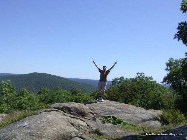
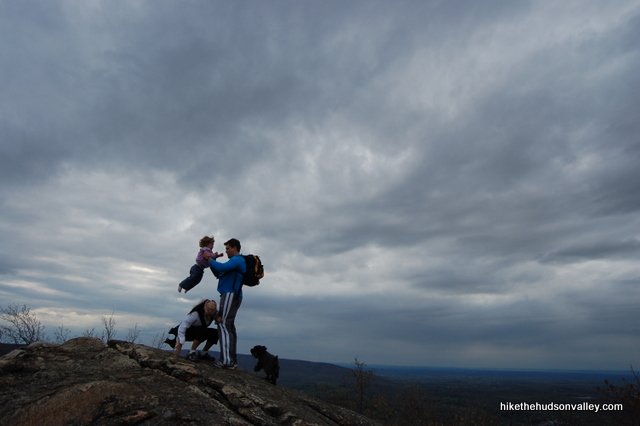
“If this hike was 100 yards longer, I would have stopped having fun, but it ended at just the right time,” reported my friend Jaime after a day at Storm King. Jaime and her husband Josh (who incidentally designed the logo and Web layout for HiketheHudsonValley.com) both pretend not to like hiking all that much, but they actually seemed to enjoy themselves here.
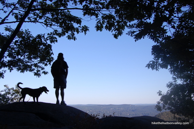
That’s their picture in the banner graphic above. Don’t the backs of their heads seem to be smiling?
And there’s plenty to smile about at Storm King.

“Oh, no, this isn’t the money spot yet,” you’ll tell newcomers to this hike as you pass viewpoint after viewpoint. As a bonus, this is one of those hikes that starts you halfway up the hill, so you get more view than you actually earn.
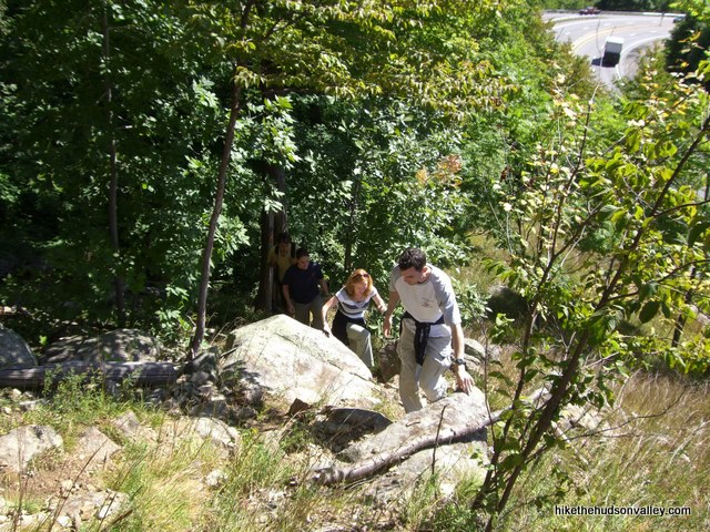
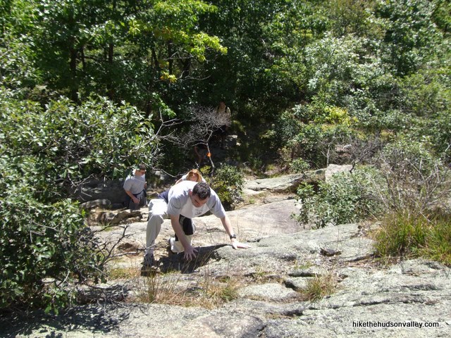
All of this is not to say that this is an easy hike. There are a couple of very steep stretches here, including a place toward the beginning that requires a little bit of rock scrambling.
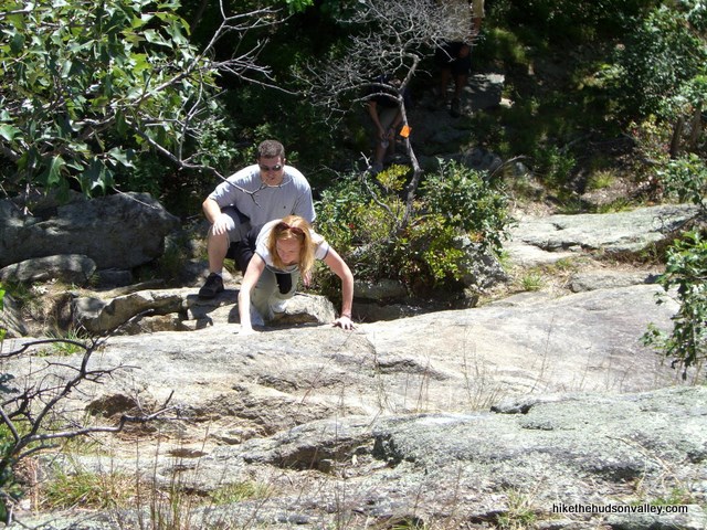
These steep stretches in the beginning are the reason I’ve given this hike a fairly beefy difficulty rating of 6. If you can get past the first 30 minutes or so, though, this hike becomes more of a meander, with intermittent views in all directions as you circle the crown of Storm King Mountain.
Besides being an all-around awesome hike, how cool is the name Storm King? I defy you to find me a cooler-named mountain. The instant you say the words “Oh, I’m just heading up to Storm King today,” you automatically become 20% cooler.
So even if you don’t like hiking, give this place a visit and see if it doesn’t change your mind. And if you already like hiking, you’re in for a king-sized treat.
Trail Guide
Bonus unsolicited advice: Don't depend on having cell service in the woods - it can be spotty out there! Download this trail guide to your phone before you head out. (It's easy to do on iPhone and Android.) May your connection to nature be strong, even when your connection to the internet is weak.
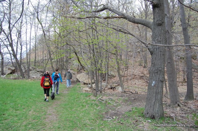
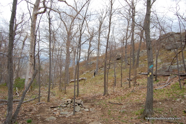
1. From the parking area on Rt. 9W, face the woods and look to your left, where you’ll see the beginning of the Orange Trail. Hop on the Orange Trail to start your Storm King adventure. You’ll see the White Trail coming in from the right, which is the end of the loop that you’re about to make. You’ll have some good memories and some tired legs the next time you’re standing at this spot.
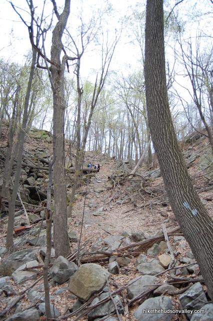
2. I hope you weren’t looking for a warm-up before hitting the steep stuff. Ascend the steep, rocky path towards the top of Butter Hill (the appetizer to the main course of Storm King). Route 9W quickly falls away behind you.
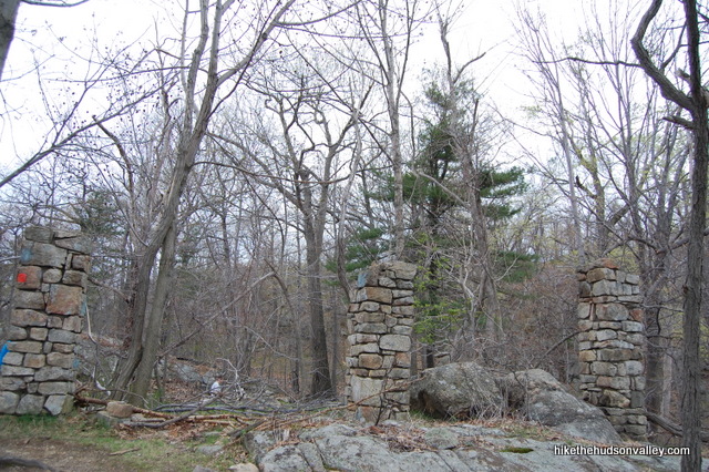
3. After the first steep stretch, you’ll pass the ruins of a small building. Want to know what was once there? Buy Peggy Turco’s awesome trail book. I honestly can’t remember what used to be there, but I know she gives that information in her excellent Storm King write-up. Since I can’t find that info anywhere else online, I think Peggy deserves some love for digging up that tidbit.
4. Head down a small saddle after the ruins, then Butter Hill demands your complete attention once again.
5. Thankfully, your efforts are immediately rewarded. As you make your way up Butter Hill, the views open up in almost every direction.
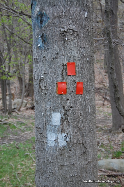
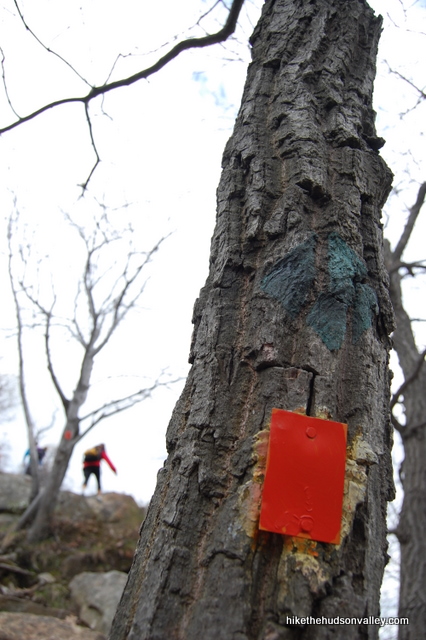
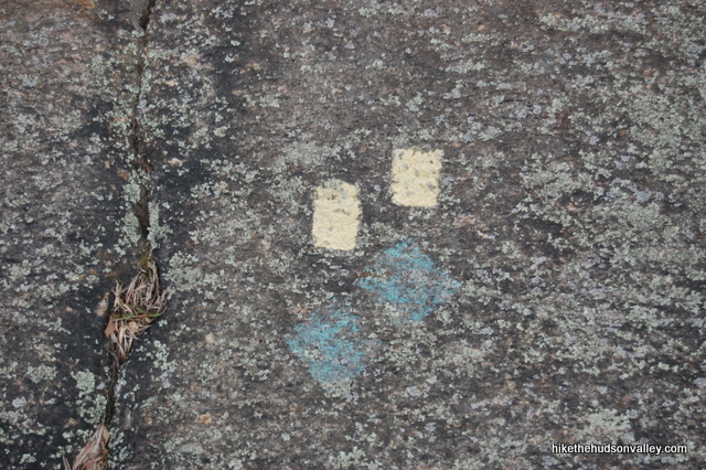
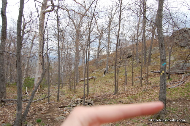
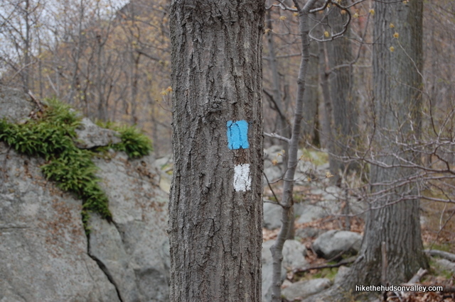
6. The Orange Trail abruptly bids you adieu when it dead-ends into the yellow-blazed Stillman Trail (which is often marked with both yellow and blue blazes together. The entire Orange Trail used to share those yellow-and-blue blazes – you might have noticed some of the faded old markings along your way). Take a right onto the Yellow Trail (a new yellow blaze has recently been added to this spot to make it clearer (thanks for the intel in your nice comment, Cailin!), but if the only blaze you see is a blue one, just turn right and walk a few feet, and you’ll see the yellow blazes, too) to continue climbing Butter Hill, which you’ll summit in just a few minutes.
**UPDATE July 2015** I put right in bold because it kind of feels like you should turn left here, and that’s exactly what at least two folks in the comments below have done. Remember: Left is not right. Boom! Check out that mnemonic device.
**UPDATE September 2015** DO NOT TURN LEFT AT THIS JUNCTION! Sorry for yelling (and underlining said yelling), but at least three people now in the comments have turned left here and gotten lost. PLEASE DON’T TURN LEFT HERE! When the Orange Trail ends, TURN RIGHT!!!!! TURN RIGHT!!!!! (Now back to your regularly scheduled non-yelling.)
**UPDATE August 2017** It’s still happening! NOW I’M YELLING AGAIN!!! TURN RIGHT at the end of the Orange Trail, or the rest of your day is NOT going to go according to plan. Okay, I’m sure this will be the last update I’ll ever have to post here. Enjoy the rest of your hike, now that you’ve TURNED RIGHT AT THE END OF THE ORANGE TRAIL!!!! (Back to normal volume now.)
SPECIAL NOTE TO SKIMMERS: Please read all of the updates directly above (including all of the words in them), especially the words about TURNING RIGHT AT THE END OF THE ORANGE TRAIL!!!!
SPECIAL NOTE TO PEOPLE WHO ALREADY TURNED RIGHT LIKE FIVE MINUTES AGO: Sorry about all this.
7. After a solid 30+ minutes of hiking from the parking lot, you’ll reach the top of Butter Hill (assuming you turned right at the end of the Orange Trail), which affords some very nice views and a rocky spot to take a break. See if you can find the round US Geo Survey marker for the summit in the stone beneath your feet. You’ve gained over 400 feet in altitude since the parking lot. You still have some uphill stretches ahead, but this is the highest spot on the hike, at 1,375 feet.
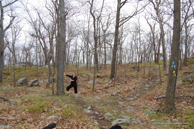
8. Continue along the Blue/Yellow Trail as it meanders across the mountain. When the blue/red-blazed Bluebird Trail intersects from the left, turn right to stay on the Blue/Yellow Trail. This intersection is also marked with a small cairn (which is fancy talk for pile of rocks.)
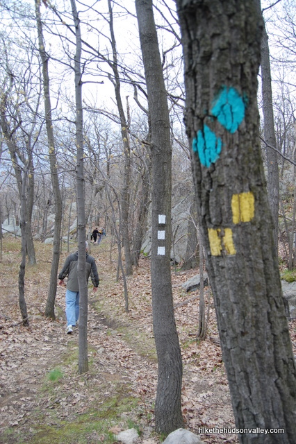
9. Just a minute after the intersection with the Bluebird Trail, the blue-blazed Howell Trail intersects from the right. Don’t be wooed. Take a left to stick with the good ol’ Blue/Yellow Stillman Trail. If you happen to have a lovely assistant, see if you can get her to point the way.
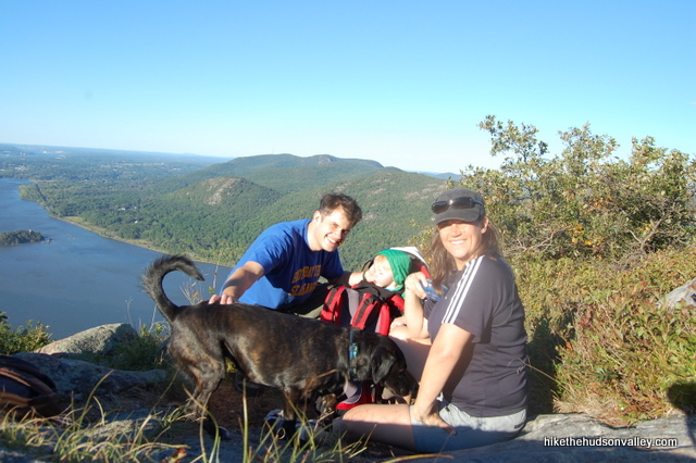
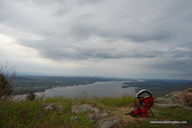
10. The Blue/Yellow Trail takes you to the northern end of Storm King Mountain, where you’ll start to get some very nice views of the river. The real money spot is yet to come, though.11. You’ll know you’re at the money spot when you get there. The Blue/Yellow trail pops you out into a rocky field with wide views of Newburgh Bay, Bannerman’s Castle, the Newburgh-Beacon Bridge, the Catskills in the distance and the eastern Hudson Highlands across the river. On a sunny, breezy day, the Hudson River will be filled with sailboats. What an awesome spot to relax and take it all in.
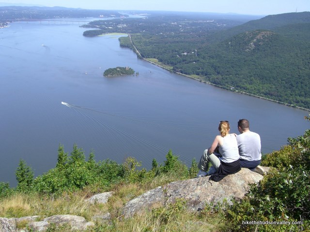
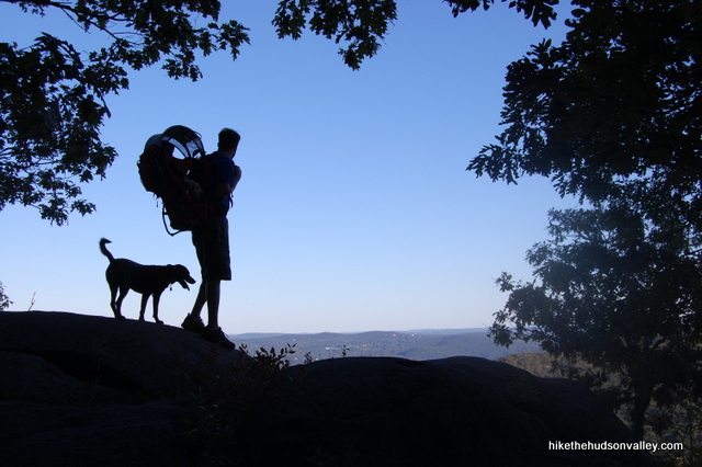
12. After you’ve chilled out here for a good long while, keep heading along the Blue/Yellow Trail. You’ll see some short spur trails heading off to your left occasionally, which lead to some more nice overlooks, though nothing as huge as you just saw. Still, they give a different view, and it’s worth checking them out. If it’s the right time of day, you just might be able to get some nice silhouette shots. Then you can use one of those shots as your banner graphic when you decide to start a website.
13. A couple of minutes after the money spot, the White Trail begins when the Blue/Yellow Trail takes a very sharp left-hand U-turn to head back around the mountain. Say goodbye to the Blue/Yellow Trail and keep going straight to hop on the White Trail.
14. After about 15 minutes, you’ll see the blue-blazed Howell Trail join you from the right. Just keep heading straight to stay on the White Trail, which is now blazed with both blue and white markers.
15. Say goodbye to the Howell Trail when it departs to your left. The White Trail takes you all the way back to your car, so keep sticking with it.
16. After generally meandering downhill for almost the entire walk back, the White Trail demands one last steep uphill climb, just to make sure you’re good and sweaty when you get back in your car.
17. That’s it! You’re now right back where you started. Except that you’re a little bit more awesome (and tired) than you were just a few hours ago.
Directions
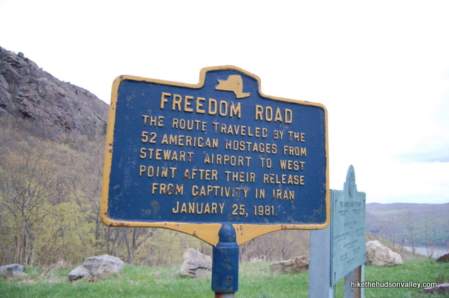
Directions to the trailhead: From Newburgh, head south on Rt 9W. Shortly after you cross under the overpass for Angola Road, you’ll begin climbing a large hill. At the crest of the hill, on your left, you’ll see the trailhead for Storm King Mountain, which looks like a scenic pulloff with room for about 20 cars. Unfortunately, it’s illegal to turn left here, and you’d be taking your life (and maybe some other people’s lives, too) in your hands if you tried it. So you have to drive three miles past the trailhead to the cloverleaf at the exit for Rt 218/ Rt 293, then drive three miles back. This is supremely annoying, but it’s the only safe way to do it. Park in the pulloff, check out the educational signage and get ready to rock.
You can also get directions by checking out the Storm King entry on the HiketheHudsonValley.com Google map.
Sorta nearby address for your GPS: Searching for “Storm King State Park parking lot” in Google Maps will take you to the right place (as of this update in July 2019). “Storm King trailhead” or “Storm King Mountain” will NOT take you to the right place, so be careful! Better yet, just click the GPS coordinates in the line beneath this one — that will get you there.
GPS coordinates of trailhead: 41.42312, -74.00101 (Clicking will open in Google Maps or the Apple Maps app, depending on your browser/device.)
Resources & Interactives
Super-cool Google Earth flyover of hike route:
Google Map of hike route:
Related resources: If you’re looking for actual facts and/or useful information, visit these resources:
- The official New York State Storm King State Park page, which actually doesn’t tell you too much. They probably laid off the person in charge of that page.
- The very informative Storm King Wikipedia page
- Some nice alternate Storm King hikes from the New York-New Jersey Trail Conference
- Another nice write-up from nycdayhiking.com
- This dude’s insane flickr photo site for Storm King and surrounding areas
Want to support trails in the Hudson Valley? Here’s one great way: Visit the New York-New Jersey Trail Conference homepage and click on Volunteer, Donate, or Shop! (Then you can volunteer, donate, or shop, depending on your mood.)
” The instant you say the words “Oh, I’m just heading up to Storm King today,” you automatically become 20% cooler.”
Is this a MLP reference (Rainbow Dash’s famous ‘20% cooler’ line)? It feels like an MLP reference.
So excited to do this trail (which is also the name of an MLP character btw!) Saturday!
RyanAndSammie, your comment cracked me up — I did not purposefully make a My Little Pony reference, but this whole site would be 20% cooler if I had. I didn’t know about that quote before you pointed it out, but I just watched it on YouTube, and now I retroactively want it to be a My Little Pony reference. That might not exactly make sense, but what fun is there in making sense? (That was a purposeful My Little Pony reference.) Hope you had a great hike at Storm King!
Just got back from doing this hike and let me say THANK YOU for the fantastic directions. I would definitely have wandered off the wrong way without them!
That’s wonderful to hear – so glad these directions were helpful to you, John. Thank you for the kind comment!
Go right!!
Right!!
Thank you, Richard! That can never be said too many times! And it’s nice to see a current picture of that intersection. Thanks for sharing!
I notice some photos of your dog in the guide — do you think the early scrambles are suitable for a climb-loving cattle dog? She’s about 35 (squirmy) pounds, so I could probably carry her for very short distances, but if it’s more than just handing her up the occasional steep scramble, I should probably pick a different hike.
Thanks!!
Hi, Sarah! There are some very steep sections here, but my 40-pound pooch always scampered right up them. I did have to pick her up and place her on top of rocks at places like Breakneck, but never at Storm King. Hope your squirmy cattle dog loves it if you bring her here! (And I expect she will have a blast.)
I’m planning on bringing my 26 pound climber of a doodle. They seem to have an easier time with rock scrambles then we do lol
Mike and Ilana, Bev had no problem on any of the scrambles! Thanks for the tips. 🙂
That’s great to hear, Sarah – thanks for the follow-up! Here’s wishing you and Bev many more awesome adventures together.
Just did this today and followed your blog. Found it spot on! I turned right! Enjoyed the sense of humor too!
Glad to hear it, Joe! (Especially the part about turning right.) 🙂 Thanks for the nice comment, glad you had a great hike!
Love the blog! This was really helpful for my wife and me. We would certainly have made a few wrong turns without the directions, and your sense of humor made the hike that much more enjoyable.
As we were leaving, two different groups asked for advice on the hike. I pointed them both to your blog.
Steve, thanks so much for the kind words, and for serving as the on-trail publicist for this site! 🙂 Really appreciate the nice feedback!
The hike felt like real rock climbing which was so fun. The rocks were easy to climb and each one had at least one spot to rest your foot and help you up. It was an awesome hike and thank god for all these reviews we turned right! Views were gorgeous!
Glad you had a great day out there, Nancy! And glad that you turned right – that’s half the battle right there!
First off I love your website. Because of it we have hiked many trails here in the NYS area today we hike the storm king mountain trail. Literally step by step instructions saved us a few times from turning left 😉
Great hike with awesome views.
Shlomo, thank you so much for the nice comment! So glad you didn’t turn left! 🙂
Great hike and directions thank you !!!
We would have been confused with out your information .
Thank you so much for such a detailed (and funny) guide! Went on this hike for my birthday and it was perfect for our group. By the way, the fallen tree on the White Trail has been cut back slightly so you don’t have to climb over it anymore. Also, they’ve added a Yellow blaze to the very important “TURN RIGHT” step which makes it clearer! Appreciate your work on this guide 🙂 Highly recommend this hike to anyone who’s scrolled down to the comment section.
Thanks so much for the kinds words and the updates, Cailin! I’ve removed the warning about the fallen tree, and changed the wording to reflect the presence of a yellow blaze in that critical spot. That’s all good news — very much appreciate you sharing it here!
I finished this hike with my family including my 6 y/o daughter and 3.5 y/o son. It took us around 3 hours with some breaks and it was fairly cold (23F). Great hike, we all enjoyed it.
Congrats to you and your hearty little hikers for doing this hike on such a cold day, Tom! They’re tough! Glad you had a great day, and I hope they earned some hot cocoa out of the deal 🙂
Thank you for the spot on directions! I went with my kids 2 weeks ago, they loved it and the views were great. We were at the parking lot around 10:00am and there were a few empty spots. The hike was a little crowded but overall a great experience.
Hi, Ermina! So glad this guide was useful to you and your kids, and that you all enjoyed the hike! All the best to you!
My husband & I did this hike yesterday following your guide. What an awesome hike & amazing views. Your guide is absolutely spot on. Thank you so much. We got there around 9:30am on a Sunday morning & the parking lot was already almost full. When we got back down about 2 hours later, there was a line of cars waiting for spots. Easy to see why it’s so popular.
Thanks for the nice comment and good information on the parking situation, Breda! Indeed, this hike has earned its popularity. So glad this guide was useful to you. Happy adventuring to you and your husband!
What an amazing hike today! Thank you for your fantastic work that you do on this site. We conquered Storm King with my 4 year old, my 8 year old and 9 year old it was awesome hike. We wouldn’t have been able to do it without your trail guide. We had to help a couple of people that got turned around a bit on the blue trail where it cut off from the white and with the myriad of trails it is pretty easy to go the wrong way. Once again thank you for another amazing trail guide!
Thank you so much, Richard! That’s wonderful that you all had a great day out there – please give your kids a giant high-five for me! (And then have them give you a high-five, too – you’ve earned it.) Here’s to many more happy adventures out there for all of you!
Thank you so much for the directions and helpful tips! We had a great time. Everything was easy to understand, definitely would have turned left if it weren’t for your post! As of 8/20 there are 3 fallen trees on the path, two on white trail and one a little before (on blue/yellow?). Just a note to future hikers. Thanks again!
Thank you so much for the kind words and the update on trail conditions, Sk13! It really just FEELS like you should turn left at that spot, doesn’t it? So glad you resisted the urge! Thanks for the nice comment, and happy adventuring to you!
Hey Mike, we just did this today. Had to wait 25 minutes to get a parking spot. But boy was it worth it! Thoroughly enjoyed it. Thank you for the pinpoint directions (yes we did take the RIGHT turn ;)). We were missing the initial experience already by the end of the hike, so we went back to the orange trail head and redid a short climb! 🙂
That’s wonderful to hear, Chintu! You’re tough, going back up a second time! So glad to hear you turned right, too 🙂 Thanks so much for the kind words.
Are there easier paths to the money spot? Also, how does this hike compare with the Red Dot Trail (Mount Tammany) in the Delaware Water Gap National Recreation Area?
Hi, Laurel! I don’t know of any easier way to get there. Perhaps doing this hike in reverse, and not doing the whole loop? But you’d miss out on so much! I would say this hike is not nearly as difficult as the Red Dot Trail at Mount Tammany, which is longer, rockier, and has more sustained steep stretches (I gave that hike an 8/10 for difficulty, and this one a 6/10). Hope that helps!
Thanks! I’ll do this one as soon as the weather is a bit cooler. Your hike looks awesome.
We just did this hike today- was fantastic thanks to your detailed guide which we followed to the tee! I love your trail guides and is my go to these days! Last week we went to tea tree reservation which was also fantastic ! Thankyou again and hope you are having a nice summer!
Thank you so much, Swati! That’s so nice to hear! I hope you all have many more wonderful adventures out there 🙂
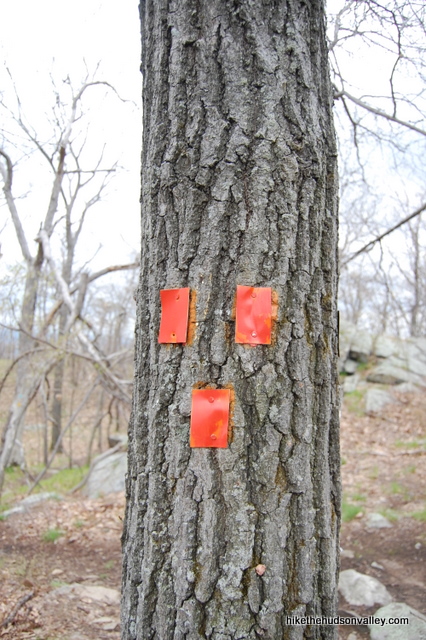
I’m a little confused in step 9 with the picture. It says “9. Just a minute after the intersection with the Bluebird Trail, the blue-blazed Howell Trail intersects from the right. Don’t be wooed. Take a left to stick with the good ol’ Blue/Yellow Stillman Trail. If you happen to have a lovely assistant, see if you can get her to point the way.”
In the picture, it looks like the blue trail is on the left (not the right) and the blue/yellow is on the right. Based on the picture it looks like I should follow on the right. However, the guide says to take a left. Is the cameraman looking backwards in the picture, after having followed the lefthand turn to stay on blue/yellow?
Ian, you’ve got a sharp eye! If you look at the yellow blazes in the picture (which are indeed on the right), they are stacked in such a way as to indicate a left turn (the top blaze is offset to the left). The three blue blazes on the same tree indicate the start of the Blue Trail to the right. Confusing, I know, but the instructions are indeed correct as written (the Blue/Yellow trail goes left, which is the way you should go). Hope that helps clarify things – good luck if you give this hike a visit!
Thank you for your kind reply! I am new and didn’t realize the nuance of the markers. Thank you for all your work on this site – it is appreciated.
You’re very welcome, Ian – glad that was helpful! Here’s a quick guide to all the various blazes you may see out there – many experienced hikers aren’t aware of all of these, either: https://hikethehudsonvalley.com/frequently-asked-questions/#Eight. Happy adventures to you!
Hiked Storm King today for the first time. Awesome hike with spectacular views. And I wanted to thank you for making the trail directions easy to navigate. Very well described and super easy to follow the trails and make the loop back to the car. Went at 9 am Tuesday morning. No crowds.
That’s wonderful to hear, Bob — thanks so much! You picked a great time to visit this hike, too – Tuesday at 9am sounds like a perfect time to hike Storm King. Happy adventures to you!
Hi there was wondering if anyone had info as to whether storm king park is open now? (During the pandemic)
Thanks!
Went today 5/3 and it was open. There were people hiking and a lot with masks which is stupid since you do breathe hard at some points.
We had to stop a couple times to let people pass. Was worth it tho.
Hi, Cee Kay! Indeed, it is open, though I’d highly recommend visiting at an off-peak time (weekday, or very, very early on weekends). I’m keeping a list of all trail closures in the area here, and am doing my best to keep it current: https://hikethehudsonvalley.com/hudson-valley-trail-closures-and-parking-restrictions-due-to-covid-19/. Hope that helps!
I headed to Storm King State Park today around 1PM and I had an inkling that I wouldn’t be able to find parking in the lot and would just have to turn around. But once I arrived, i did not expect to see that the lot was overflowing with cars parking on the side of the road before and after the parking lot. There were over 10 cars on each side of the parking lot. I could have parked on the side of the road as well but the abundance of people is a dangerous situation and I decided it was in my best interest just to head back home. The amount of cars that were there was more than I have ever seen it even during non-pandemic times. Go at your own peril and definitely outside of peak hours.
As a heads up. As of yesterday’s wind storm, at the end of the orange trail, at the triple blaze, there are many large limbs/trees down making this confusing part of the loop trail even more confusing. I know people have made many mistakes before, and this does not make it any easier at all!
Apr 15: In addition, the trail going left is also marked Blue/Yellow and some of the markers are very new. The trail going right is barely visible and requires going under a couple downed trees which also make the path difficult to discern.
We arrived yesterday morning around 10:30am, after exhaustively reading through your hike recommendations. I was a bit nervous, having never hiked upstate before. I didn’t know how well the trails would be marked, etc. I shouldn’t have been worried – your detailed instructions were perfect! 14 and 10 year old even enjoyed themselves. We saw less than a dozen people on the trail though by the time we left at lunch the lot was full. I have the feeling we will be using your guide more often in the coming weeks looking for social isolation outdoors.
I wish I had read your guide prior to completing this hike. The trails make much more sense after reading your description. I somehow started from the small parking lot (max 6-8 cars) right off of mountain road where the trail started with a yellow blaze. Took that that trail up until I reached the blue and red blazed trail and followed that until I reached the blue and yellow blazed trail which moved uphill for a good amount of time and then headed back down. I’m sort of a beginner with longer hikes and the downhill parts of the blue and yellow blazed trail were super nerve wracking since most of the rocky sections were covered in ice as well. Somehow I continued on the blue and yellow until I reached back to the bottom of stormking where the path lead back to the parking lot.
First time up and this guide was spot on! There are certainly a few sections of trail that may be sketchy for a true beginner, but I was able to do the scrambles with the little one in the pack (not tooting my own horn just saying that the well-marked rock sections will take you up the scrambles appropriately). We actually stopped to have our lunch at the first big view after the summit (not the money view!). This ended up working out in our favor, as it was super quiet compared to the money spot, and flat for us to sit for a bit! I agree with the parking info update, led us right to where we needed to be! A great rewarding hike without being too killer on the legs. Thanks for the valuable info!
Sounds like a perfect day out there, Zach! Here’s wishing you and your little one many more happy adventures!
We turned RIGHT! Thanks as always for a comprehensive and entertaining guide. This is one of our new favorite hikes!
That’s wonderful to hear, Amber! Are you sure you shouldn’t have turned left, though? Ha, no, really glad you had a great trip out there, and thanks for the kind words!
Hi! Excellent guide, I plan to hike this in a few weeks. I will be sure to turn right.
I’m wondering can anyone tell me if there are any decent campgrounds within backpacking distance of Storm King? (Assuming dispersed camping isn’t allowed on the area.)
Thanks!
Hi, Gabriel! Glad you’re all primed to make that right turn! (Left is also a popular option there for some reason.)
Camping on Storm King is indeed not allowed, and I’m afraid I don’t know of any spots within backpacking distance. Harriman State Park isn’t too far from there, and it has shelter camping (with tent camping allowed near the shelters), but I’m afraid it would be a 15-minute drive between the two. Hope you have a great trip, and would be curious to read it if anyone has any better advice for you!
Your notes and advice for this hike were absolutely spot on, including intersecting trails, where the climbs were, and most important, where the views were. We are over 60 and not mountan hikers (we live in a flat place hundreds of miles to the west), but we took it slow. It took us a bit under 3 hours allowing for time to admire the views. It was tiring but rewarding, and we enjoyed some cold beers afterward in Beacon. One minor point is that the first keyword search option in GoogleMaps took us to a different entry point about a mile north off a side road (Mountain Rd). Your trail description was enough to let me know we were in the wrong place within about 10 minutes. I then reread your description of the starting point and it was perfectly accurate.
Michael, thanks so much for the nice feedback! Glad you had a great hike out there! I’ve updated the instructions above to advise people not to use “Storm King trailhead” as a search term in Google Maps (“Storm King State Park parking lot” does the trick, though). Hope that helps others avoid the same fate — thank you!
Thank you so much for your time and energy in this site!! I have become virtually obsessed with hiking because of this site. I did this hike today and if it weren’t for your detailed directions I would have turned back because there was about 20-30 minutes of hikeing that I thought I made a wrong turn, But with your input and pictures that you post I knew I was going in the right direction!! So THANK YOU so much for your work here!! I’m on your site almost every day looking for my next adventure!!!!!!
That’s awesome to hear, Mark! Thank you so much, and here’s to many more wonderful adventures to you! I’ll have to bust out some some new trail guides soon to keep up with you 🙂
What a wonderfully thorough and accurate guide for this hike with great views and some fun rock hiking.
Thank You!
Thank YOU, Richard!
What a great hike and a great guide! The map that opened up in google was extremely helpful and helped us get back on track at one point when we had taken the wrong fork. Thanks so much for this, and we can’t wait to try out some other hikes from your website! – Nancy and Lou
P.S. an easy way to put the parking lot into GPS (at least on google maps) is “Storm King State Park parking lot.”
Thank you, Nancy and Lou! Glad to hear you all made use of the Google Maps GPS track, too – I feel like that may be an underutilized resource on this site. I also just updated the driving directions to tell people to use the exact search term you recommended, since some other terms that seem correct will actually take you to the wrong place (as another commenter above just reported today). Thank you – much appreciated!
I went on this hike alone and I enjoyed it SO MUCH. This guide definitely helped me out during the hike, as I got lost at one point. THANK YOUUU.
This hike was BEAUTIFUL!!! For 3 people who DO NOT hike on a regular basis and decided at 11:00pm on Saturday night that we wanted to go hiking on Sunday, this was a great hike to pick!
We used this site to narrow down which hike would be best for the day, after some research we determined at 1am that we wanted to do a totally different mountain. When we woke up we decided that the original trail we had picked was a bit ambitious, and decided to go for our backup plan, Storm King. Yes it was steep at times, yes it was scary at times, yes we sure felt like we were going to die at times. But all in all it was a FANTASTIC day!!!
I recommend following Mike’s directions very carefully. At one point he says that it may look like you want to/should go left. He was right, it totally feels that way, but follow his directions and you will do the full loop and get some amazing views!
Mike- Thank you for your help and your website, without you and your insight we wouldn’t have been able to have such a great day, hey we may not even be back to write this comment.
Also note *this was a very last minute hike, we made it with the bare essentials but I do not recommend doing it this way. As I was getting my things together the morning of I sent my friends and my family a message that read, “There’s so much prep involved in hiking. Last minute hikes should be against the law!” I’m sure some people who hike a lot can figure out what they need in a matter of minutes, but for first time hikers I highly recommend against it. Make a list, research, prepare, have fun! Felt great to be out in nature and smiling no matter how hard it was, it was totally worth it!
Erin, this comment made me smile when I initially read it, and I apparently neglected to reply back then. But I come from the future to say: THANK YOU! And glad you had an awesome day out there. I bet you’re prepping for your hikes in no time these days 🙂
Hey Mike,
Quick question! We are planning our trip to Storm King sometime next week and were wondering how difficult it is for dogs. The steep parts you mention worry me, but I do see pictures with Memphis so you must have successfully gotten him up there. My one is 110lbs and not so graceful, do you think he could make it? Im pretty sure my medium size lab mix could? Reassure me! (haha)
Hey there, Katelin! You’ll know in the first ten minutes whether or not your pooch is up to the challenge — that scrambliest spot happens very early in the hike. While I’m always hesitant to make generalizations without knowing the pooch in question, I strongly suspect that your klutzy lab will be just fine. My pooch has never needed any help on this hike to hop up the few steep rock faces, though she does sometimes hesitate for a moment while she figures things out. Most healthy dogs should be able to navigate this hike with very few (if any) problems. I really hope this is good advice and you feel reassured — I’d love to hear how everything goes. Happy adventuring to you all!
Hi Mike,
Am planning a hike to either Storm King Park or Breakneck Ridge within the next 1-2 weeks. Do you know if there any bears on these trails?
Hi SharadY! Your chances of running into a bear out there are vanishingly small, but it really could happen in either of those places (and most of the other hikes around here as well). I’ve heard of bear sightings at Breakneck and at Black Rock Forest, right across the street from Storm King. I’d recommend boning up on what to do in the unlikely event of a bear encounter (here’s some great advice from the NY DEC: Black Bear Encounters) and enjoy your day out there, whichever hike you decide to tackle. Hope this helps!
Thank you so much for your website! My husband and I made a quick weekend trip the Hudson Valley and I stumbled on your site as I was planning our hikes. We always second-guess ourselves on trails and your play-by-play directions were awesome. We hiked in the fog on Sunday (it was still a great time, in its own way)…but we might have to come back and try it again for a nice view of the Hudson next time! If so , your website will be my first stop! Thanks again.
Just wanted to note that there is no bathroom or port-a-potty nearby so if anyone expects to use one here, go before or you’ll have to hold it like I did!
Have you tried the North Point Summit Trail at Storm King? I think that merits its own trail guide. I went up there Saturday morning and some of the views are just incredible – would have been even better if the clouds had lifted. The parking area on 9W was a pain to find in the fog – drove by twice before I spotted it – just about 1/2 mile south of the trailhead for the Storm King hike you outline above. From the trailhead, I took the blue Howell Trail counterclockwise to the white-blazed Stillman Trail. The first two miles were almost all downhill and not particularly interesting, but once you hit Storm King Highway (where there is another small parking area), you get back on the blue Howell Trail and start to climb a series of switchbacks up the side of the mountain. It’s taxing but not hugely difficult. Then you reach a set of stone stairs in the mountainside that go up, offering one great view after another – across to Cold Spring and Bull Hill/Mt. Taurus, up toward Breakneck Ridge, further north to Bannerman’s Island and the Newburgh-Beacon Bridge, and of the dramatic cut out of the Storm King Highway along the Hudson. It would be even more amazing in clear weather. On the way up it’s worth peeking at some of the views off to the sides of the trail. keeping safety in mind. Finally, you cut across the top of the mountain, go down a bit then emerge at the North Point Summit, with more great views. Coming back down from there to the trailhead the hillside is absolutely covered with wild blueberries. Wish I’d brought a basket. Very rewarding hike. I guess you could also start the loop at the Storm King Highway parking area and frontload the climb, but I’d rather get my reward later in the hike. If you just wanted a short hike you could also go clockwise directly up to the North Point Summit then return to the parking area. I’m guessing that would be less than 2 miles roundtrip.
I’ve now hiked Storm King three times and really love the views and level of difficulty. Still, all three I’ve failed to finish the loop and end up turning back and going down the same way I went up. There comes a point after the last peak when I start following the white trail but cannot seem to find the next marker after a giant pile of rocks. It’s happened every time, right after the silhouette shots. I’ve even tried going with two sets of different people, thinking it might be me but it’s been the same deal. Anyone else have this trouble? Any more tips, like visiting another optometrist? Thanks!
Lillian, oh no! I’m really sorry to hear that. I wonder if there have been some blowdowns from the bad storms we had this spring, or some other change that is obscuring the way forward. The White Trail heads straight at that point, and I’m guessing the pile of rocks you’re seeing is a cairn to mark the spot where the blue-blazed Howell Trail departs to your left, heading steeply downhill. From there, you should be able to follow the White Trail straight ahead, and those blazes will take you all the way back to your car.
That must be so frustrating to turn around when you’re so close to completing the loop. I’m really sorry you’ve had this experience, Lillian! If anyone sees this comment and can offer some more recent advice on what may be happening, please offer some guidance! I’d really like to solve this mystery and make sure others don’t run into the same problem.
Hey guys, I went up to Storm King for the first time yesterday and I can tell you that the white trail back around is blocked by a fallen tree. It’s in the middle of the path in the woods but just before the steep climb back up that will take you back to the parking lot. You just have to climb over the tree! Hope this helps!
You cracked the case! Thank you so much, Michelle! This one was really bugging me. I’ve updated the trail guide above (Step 15) with a warning and a link to your comment. Much appreciated – THANK YOU!!!
Matthew, I’ve considered doing a variation of the loop you’ve described here (though I’ve never been), and you’ve sold me on it now. Thanks so much for all the nice details and recommendations, along with that very cool photo. I’ve updated the “Coming Soon(ish)” list on “The Hikes” page with this hike. Very much appreciated!
That’s great – looking forward to eventually seeing your guide! This site has been an awesome resource for me as someone who just got into hiking over the past year. Off to Alander Mountain this Sunday if the weather cooperates.
Thanks for a nice and detailed info. I just glimpsed at it before going hiking with a meet up Hudson valley hike group, but i missed to meet them on time and end up hiking by myself. But the pictures from your article helped me to navigate on my own and come back to my car.
Excellent information! We had a great time today using your guide, despite the rainy weather.
I always get lost on trails, but your directions were perfect! I took my four kids and we didn’t see another soul on the trail yesterday and we had no trouble at all. Parking still closed so we squeezed in at the edge of the lot.
as of 6/17/18 the parking lot is still closed, but there is room to park along the roadway. thanks for the trail guide – definitely would’ve gotten lost without it!!
Tried hiking storm king today only to find the trailhead parking lot closed due to construction. Looks as though they might be freshening up the place. Hopefully this won’t be the case for too long. Anybody know when it’s protected to open back up?
Hi Juan,
I posted the question to the site’s Facebook page to see if anyone knew what was going on. The response:
“Storm King trailhead parking lot on Rt. 9W, Cornwall will be closed for paving June 12-15th. There are other parking areas on Rt. 218 and a small lot on Mountain Rd.”
Sorry for the inconvenience today – that must have been a bummer. Looks like it’ll be open again by the weekend, though!
Thanks, Mike, for the quick response. Your site is the reason I took up hiking and I recommend it to anyone who asks. Keep up the great work.
anyone have an abridged “cheat sheet” take with you version of all these directions? 🙂
I know brevity is not my strong suit, but I strongly recommend reading all of the words in the trail guide if this is your first time doing this hike. (See Step 6 above for the fate that awaits the good folks who decide to skim the directions.) Hope you have a great hike out there!
This is my birthday hike with the fam so I’ve read and printed the directions. I know, go right!
Can’t wait! Thanks for the response!
Just got back from hiking this route. What an amazing trail with lots of views! Thank you for the wonderful write-up! I truly appreciate all the work you put in to the website. Directions were very accurate and detailed.
Thanks so much, Christine! Bonus points to you for tackling this hike on such a cold day (barely got above 20 today). You’re tough! I bet crowds weren’t a problem out there 🙂 Glad it all went well, thanks for the kind words!
Thanks you so much for all the detail & effort you put into these posts! We greatly appreciate them.
We just completed Storm King today (well sort of 😉 I’m risking getting streamed at 😉 to leave my thoughts on why I think so many people make the same mistake at the dreaded turn.
When we’re told to go right on the blue/yellow trail it’s not clear that you will be staring at two paths:the one to the right is light blue (which we know now only has a blue marker but will soon alternate yellow/blue) the one to the left (that curves right down hill) is yellow/blue. What’s in your head? Stay yellow/blue!
People! at the end of Orange, turn right up hill on light blue! It’s the right way. Ignore yellow/blue straight in front of you. If you follow it you will end up at Storm King School & road. It continues on road through weird tunnel & then some (turned back). If you took yellow blue straight (left) you will come to a white trail too. Is this the white trail back to lot? NO. This white trail falls off the end of a cliff? As far as we saw trail has 2 markers then disappears.
Hope this helps – can’t wait to return & do it proper.
thanks – this is helpful
Great hike, very good instructions. My friend and I managed to get lost *a different way* (I think) and nearly went to the Rt. 218 lot/trailhead before a nice man redirected us onto the blue/yellow trail, summit, views, white trail headed back to the correct parking lot etc.
Few things: this is a VERY popular hike, especially on fall weekends. We looped on 9W twice before a parking spot opened up. I noticed that other people parked on the southbound side of 9W, right where you can cross the highway (but NOT a U-turn spot!!) to get to the trailhead. There is also room for a few cars on the northbound (trail-side) shoulder of 9W at the each end of the parking lot.
I’m really sorry to hear that you got lost, too, Ami. Yes, that does indeed look like a different way to get lost. Congrats on not making the dreaded left turn! Do you know where things went wrong? Are there changes I can make to the trail guide to keep others from doing the same thing?
Hello, this is an awesome instruction! The view is stunning Thank you very much! I am planning for a hiking trip in October and can use some helpful advices. We have a group of young families with kids around 5-8 years old. Would you suggest this hike or is this too difficult for younger kids? And do you happen to know the parking situation during October? We heard parking in Bear Mountain is crazy due to October Fest. If we arrive at around 1-2pm is it too late? Thank you in advance!
Hi, Haiying! My oldest son did this hike when he was four years old (with a little assistance), but my youngest son is now five, and I don’t think I’d take him here quite yet. Depends on the kids! It is a tough hike with very steep sections. The parking on the weekends here at all times of year is quite busy (see Ami’s comment above). Depending on your pace, 1-2pm should be okay (it starts getting dark around 5:30 these days), but I wouldn’t push it too much later than that. I’d also make sure to bring flashlights, just in case — seems like people enjoy getting lost on this mountain, and I’d hate to think of anyone wandering around this mountain after dark, trying to find their way. Hope this all helps — happy adventuring!
Hello, there!
I’m looking for directions for an upcoming hiking trip for a group of us. I stumbled onto your website. Thanks for such great information. Just one question: do you know any good location close by this storm king trail that our group can have picnic at after the hike? Thanks!
Hi, Joanie! There is a grassy area in front of the parking lot — wouldn’t be the most relaxing place to picnic, but it could be an option. Plum Point Park in New Windsor is an eight-minute drive north from Storm King, and could be a nice place to relax afterwards (and they have picnic tables!). Hope that helps!
Thanks for the very detailed instructions! They were perfect, and made us laugh + enjoy the beutifull path 🙂
That’s wonderful to hear, Tamar – thank you so much, glad you had a great day out there!
Just finished this hike and wanted to provide a warning that following the blue/yellow tags towards the end will not always lead you to the “money spot”. Our group, along with at least 6 other groups we saw retracing steps and using this page for directions ended up at the Storm King school. We may have taken the dreaded left turn instead of right, but we believe we reached the peak afterwards, so not sure what happened. Just a note to future travelers to take this page with a grain of salt as we saw multiple people track back up the mountain and never reach many of the areas this page describes. Make sure to read from multiple websites before beginning!
Hi NA! I take the accuracy and clarity of these trail guides deadly seriously, and don’t want anyone taking these directions with a grain of salt. If there is an error or an unclear choice of words, please, PLEASE, correct them with a comment here and I will update the trail guide accordingly. Based on my personal (and recent) experience at Storm King, as well as the many comments below verifying the directions in this guide, I have to assume that if someone got lost here, it’s because they took a left turn at Step 6 above, especially if they ended up at Storm King School (which is exactly what happens if you go left there). I’ve posted multiple warnings above, and don’t really know what else I can do to help people avoid that fate.
It makes my heart hurt to read your description of multiple people using my guides and getting lost. I greatly prefer to read stories of people using my trail guides to lead other lost hikers out of the woods (like Luis’ comment from two weeks ago). My best estimation here is that folks are STILL making that left turn at Step 6 and getting lost as a result.
I’ve added a new warning to Step 6 above. Hopefully, that will help anyone who missed the other warnings. Let me know if you can think of anything else that would be helpful. Sorry you didn’t have a better day out there!
Mike, I did this hike last year, no issues at all.
Granted, I also know how to read and follow directions, which is why your site is so helpful!
Keep up the great work, and thanks for all the awesome hikes you’ve mapped out. I recommend you to everyone on the trail.
Best,
Dave
Thanks so much, Dave! Very much appreciated.
rude
No one asked you Dave
I’ve hiked this trail many times following HiketheHudsonValley.com’s directions here and it sounds like you did make the dreaded left turn instead of a right turn when you got to the yellow/blue trail. The left turn on yellow/blue does lead to a school, but if you make the right turn onto yellow/blue described above, the trail soon goes just around the top of Butter Hill (worth the few steps climb up to the top, where there’s a beautiful view & a very old survey marker) and past a couple of other viewpoints before it leads directly to the rocky knoll Mike calls “the money spot.” The only other point in the hike that’s confusing is just after the Bluebird Trail comes in on the left about 1/5-1/4 miles after Butter Hill–#8 & 9 in the directions above. No matter how many times we hike this trail, I always have to double check the directions twice: first when you have to go right to stay on the yellow/blue trail, and then again after maybe a minute, when you go left to stay on the yellow/blue blazed trail (see photo with #9 above).
I used the instructions yesterday with no issues. They are really clear and to be honest it’s not anyone’s fault but the reader if they fail to follow the directions!
My family and I just did this hike yesterday and it was absolutely amazing. I had my 1 year old son on my back in a child carrier and we also brought along our 12 year old shih tzu. Our dog only needed to be helped a couple of times on the scrambles, she managed the vast majority of the hike extremely well.
Anyway, this is my new favorite hike and I can’t wait to go back. Thank you so much for this detailed hike description and map, we would’ve definitely gotten lost without it.
P.S. Midway through the hike we encountered a group that had gotten lost and didn’t know to get back to the parking lot. I pointed them in the right direction and showed them this site to use as a guide.
That’s really wonderful to hear, Luis! Thanks so much for all the kind words, and glad you and your family had a great day out there!
Well. I’ve done it. I have made the infamous dreadful left turn, even after the warnings not to. I probably hiked for over half a mile, until I turned around and traced my steps. Overall though, the hike is absolutely gorgeous. The rocky steep areas are a lot of fun, but most of the hike is relatively flat. It was my first time hiking and I ad an incredible time. The instructions are dead-on. Thank you
I don’t know what it is about that turn — I visited Storm King again a few months ago, and at that spot, I thought, “You know, it just really seems like you should make a left here.” Glad you were able to salvage the day! You sure picked a winner for your first hike – congratulations!
Is this trail possible to camp out for the night? Would I be fined. Trying to camp out for the night at the top ? Would love to hear you thoughts
There is no camping at Storm King.
Hi Ramon,
Indeed, camping is not allowed here, and a fine would certainly be possible. Even without the fine, I’m a big proponent of following the rules, since they almost always exist for good reason, even if those reasons aren’t immediately obvious to the casual observer. In general, when people choose not to follow the rules, they risk wrecking a good thing for the rest of us, and also risk creating land management problems for the good folks in charge of protecting the precious outdoor resources we’re so fortunate to have available to us.
You can find some great local (and legal) camping suggestions in the FAQ: http://hikethehudsonvalley.com/frequently-asked-questions/#Fourteen
Thanks for checking – hope this helps, and happy adventuring out there!
Thank you so much for this guide. Wanted to hike storm king after hiking breackneck and this guide got me through step by step. Awesome!!
So glad to hear that, Naminu! Thank you!
Is there any public transportation like train or bus that stops near by? I don’t have a car but would really love to visit.
Hi Han! I’m afraid I don’t know of any. I’m not an expert on local public transportation, though – there could very well be some options to get you close, but probably not close enough to walk to the trailhead. Something like Zipcar might be your easiest bet, if that’s an option.
It looks like it’s about a 20-minute drive from the Salisbury Mills/Cornwall rail station on NJ Transit.
You might try to call a taxi service local to there and see what arrangements you can make.
I’m going hiking with my family next week for Thanksgiving, and this is the best guide I have read about any trail! You are hilarious AND informative. Thank you.
Thank you so much, Helen! Hope you had a great hike!
Perfect Trail Guide! Hiked Storm King Mountain last weekend and just viewed on my cell phone, the pictures and directions in this guide are almost eerily spot on! Cheers!
Thanks for the directions – they were really helpful. Great hike!
Thank you for writing this. I went for the first time today and it was wonderful. Your instructions were so helpful!
After my first go ended up being cut short due to a downpour, made it up Storm King this time and it was fantastic. The first and last quarter were familiar as I did the Butter Hill-Howell-Bypass loop the first time. However, the views and the hike’s “jewels” are mainly in the upper half.
Attaching a map with the route Mike described sketched and hopefully it will help folks who are new to the trail system. The Stillman trail is marked by a yellow and diamond teal marker (as seen on the map). Howell is a blue square/rectangle.
Highly recommend this hike as over the course of it, you’ll have compiled a 360 view* around the mountain (*if you check out all the viewing points). I was and am curious if the Stillman-Bluebird leg holds any more excitement and wonder if it’s worth another trip.
You’ll also see Breakneck Ridge. Perhaps the next hike… 🙂
Hi, I just want to say that you did a fantastic job with this guide. It is so spot on and helpful. I saved multiple people from turning left at the split instead of right because I read this ahead of time. Thanks so much!
Hi. I believe the illusive right hand turn that seems to confuse so many has been re-blazed (is that even a word?) My picture shows the end of the orange trail blazes on the left and a pretty yellow and blue blaze on the right. Right at the intersection even. Thanks for a great website. I reference your site all the time.
Attempt 2 at posting pic
I stumbled across this website randomly and it was a treasure trove.
Did the Storm King hike and the directions were spot on. Lovely hike. After the initial scrambling, most of the hike was through wooded areas away from direct sunlight…which makes it more pleasurable.
(though we stopped by the parking lot to check for directions and found it to be the right one!)
Now browsing your list to find my next hike.
Thank you thank you thank you! ! This was a great hike!! Your directions were on point for a novice like me!! For those new to hiking make sure you have good shoes and bug repellent!!
One more time thanks for this site! !!! Can’t wait to hit your other trails.
Thanks so much, Johana! Beautiful shot!
Mike,
Thank you very much for the detail step by step guidance, it was a lovely hike today, me and my wife enjoyed a lot.
Regards,
Sam
Michael, thanks to your accurate details of direction and trail information, our family had a great time hiking Storm King Trail on July 3rd. Your GPS location led us to the parking lot without no problem. We started from the Orange trail, which is next to the White trail. After we got to the top (your Step 7), there was some confusion on finding the Blue/Yellow trail leading to the White trail. All hikers there around 10 people just turned back to the orange trail, which can be challenge in a couple of steep places going down. It took us a minute or two to find the Blue/Yellow mark on the right side marked on the the rock leading to the White trail (Step 8). This trail aperently is less travelled and most part is flat. We kept walking in the woods and used cell phone service checked our location a couple of times. More than 20 minutes later, we saw the Hudson river on our left side and assured we were on the right direction. The rest of hiking was easy and we found the White trail and follow it back to the parking lot. Bonus point: lots of wild blueberries to pick and eat along the way
Thanks for the explicit directions including driving directions…it was very clear….We had a great Father’s Day hike today. It was our 1st time at Storm King Mtn. We loved the views AND the rock scrambles.
Awesome, Nike! Sounds like a great way to spend Father’s Day.
We’ve missed the white trail back to the parking lot at Storm King, too, but last time we were on that trail, a couple of weeks ago, it was definitely there. Great views can also be found along the southern portion of the Howell Trail accessed from the parking lot on Rte. 218 at Stillman “Spring” (which looks less like a spring and more like a rectangular, vertical rock someone put in place to disperse the water from a small brook). Trailhead is to the left of the spring. Steep climb up, almost no one on the trail, definitely worth it. Yesterday we had planned to make a loop by getting on the Stillman Spring Trail to come back to the parking lot but decided to go back the way we came after we saw a bear ahead just south of North Point.
I’m looking to do a sunrise hike on Sunday. Is this a good hike to see the sunrise? If so, great! If not, could you recommend one to me? It’s for a photographer to take photos of my boyfriend and I on our anniversary, so we want the best spot for the sunrise with the best views! Thank you!
Sorry I didn’t get this response to you earlier, Amanda. Looks like you guys had a great morning for it – thanks for sharing your photo on the HtHV Facebook page! Awesome shot! Glad everything went well for you guys.
Mike: I did this hike today and I must say this is my new favorite hike!!!! Perfect directions as usual! Keep up the great work!
Excellent! Really glad to hear it, Tom — thanks so much.
We did this hike today and it was amazing! Your directions were absolutely GREAT! Thank you very much.
Hi Mike!
Just wondering if this train is doable with a dog. I’m worried about the rock scrambling in the beginning. He’s an 8 month ridgeback pup who did great using your trail guide for black rock forest! I know this is a little steeper of a climb and hope he will be ok!
My 40-pound pooch loves this hike, never had a problem with the rock scramble. I’d expect your pooch to have no trouble as well, but I can’t guarantee it. Hope that helps — happy adventuring!
I printed out Steps 1-17 (in color) plus directions to the Trail Head. This was invaluable. Made the hike for my wife and I really enjoyable; especially the times we we had to offer directions to others who either had no directions or couldn’t read their cell phones because of the glare. Thanks so much for your efforts in creating this sight. Please know it was really well appreciated and useful.
So glad to hear it, Ken — thank you!
Thanks for the awesome directions! My wife and I were in the Hudson Valley for a few days as a birthday present for her. We were on our way home to PA on 10/27/15 when I took a wrong turn on Route 9 and came upon the trailhead. We stopped on a whim and when I realized where we were (I had come across your site the day before while researching Storm King), we just couldn’t NOT do the climb. I had this site at the ready on my phone as we ascended and every portion of the hike was made even more fun by your commentary and directions. We emerged 3.5 hours later (we’re probably a bit older than you judging by your temporal measurement of distances) tired but very happy. Thanks for the experience!
Sounds like a serendipitous wrong turn, Mark! So glad to hear you had a great day out there. Hope you enjoyed your time in the Hudson Valley – come back and see us again sometime soon 🙂
What a great hike!
Storm King is the perfect hike if you want to do some cool hiking and scrambling but don’t have an entire day to do so. There are a few spots with some rock scrambling that was a good time, not too challenging, but definitely places where you’ll need to concentrate. It’s a short hike, and there are so many view points that you might not even realize that you’re really at the payoff. Me and the LADY! ended up sitting on an outshoot that was about 5 minutes before the real payoff spot, without even realizing that we weren’t at the best area!
Once you do get the the very top, the views are just awesome. Hudson Valley, Hudson River, Breakneck Mountain (Which, if you’ve climbed it, makes you go “Wow, I climbed THAT?”) and there are several places to sit down, enjoy some snacks, and take in the view. Even today, when it was really overcast, the sights were just great!
I could see this hike becoming a “I just want to get out and get home” type of hike in the future because it’s a cool challenge, but it’s not too long, and the views are worth the efforts!
It took us about 2 hours from parking lot to parking lot.
Did this hike Oct.18 2015. The hard part was the first 30 or so minutes from the beginning the Orange trail right off the parking lot to the three stone pillars. As everybody who has done this trail, it’s a climb. I went by myself, and a partner would have helped (58 yrs old). Summiting Buttermilk Mountain means the rest of the trail to and down from Storm King isn’t too hard, just the usual rocky and undulating trail. It actually rained and then flurried last Saturday on the mountain. If one wants to get to the top of Storm King without seeing Buttermilk Mountain, go right at the parking lot and follow the White blazes.
Great write-up of this spot! I very much enjoyed this hike. I thought your directions were clear – in fact, I turned around once on the blue/yellow because I thought I must have missed something when it seemed so simple. I decided to keep going and there was the junction you pointed out (or I should say your assistant did) and I knew I was on point. Definitely not as difficult as I had anticipated it might be and fabulous views! Love this site!
Wonderful hike today and wonderful directions! Thanks for providing the best directions on the web–there were others out on trail today waving around your directions and the one couple that didn’t, ended up following us out.
Thank you!
I also encountered a group with these directions! I felt like I was part of a secret club!
Did this hike for first time yesterday – your directions were perfect! Really appreciate this site! Found it recently and have only done one other hike so far (Mt. Beacon), but am looking forward to trying more!
Thanks so much, Jeannine!
The trail guide for storm king mountain was great. . Really helped us to actually find our way back to our cars 🙂
Oh and the recent update for gps coordinates to the trailhead was helpful before even starting the hike too ha
Any suggestions for guiding a group of 20 up Storm King Mountain?
My husband and I took 6 of our kids yesterday in the rain. It was awesome and so enjoyable. The kids range in age from 12 years old to 3 years old. We had a blast!! You’re directions were spot on and helped make our hike so enjoyable. Also a great teaching moment for the kids on how to follow the trail correctly and safely. Thank you!!
That’s so nice to hear, Caroline! Your kids sound like hearty adventurers! Thanks for the kind words, and so glad you all had a great day out there even if the conditions weren’t perfect!
Once again, thanks for such a great site. My wife and I did this hike yesterday and really enjoyed it – some great views, and with a good mix of wooded and open areas, was fine on a hot day. Followed your directions which were super clear. For those headed North on 9W, the trailhead parking is marked with a big blue Parking Area sign. There are also alerts a mile or two beforehand with similar signs.
Just finished this hike with my soon-to-be 9-year-old daughter. Your directions were very clear and it was a beautiful day out there. Never would have been able to do it without your guide, so thank you!
Mike – thanks so much for this handy guide. We did this hike this past weekend (7/3/2015) and things looked a little different up there (mostly because it’s summertime and the trees have leaves–I think the money spot might be better in the fall/winter, when there isn’t as much shrubbery in the way). Our biggest issue was going back–we found a couple of markers for the white trail, but we (along with a couple other groups of hikers) could not find the subsequent ones! We didn’t see the tree with the three white markers lined up vertically; instead, we saw one that looked like a triangle (one on top, two on the bottom). We wound up taking the blue/yellow down the other side of the mountain, which popped us out at Storm King School and was about a mile away from the parking lot — the only choice was to trek back up the mountain tracing our original route. So if any other hikers are heading up, don’t take the blue/yellow down the mountain! Otherwise, this was a very do-able hike and we enjoyed it. Additional details on finding the white trail back would be helpful.
Sorry to hear that the end of the hike didn’t go as planned! I’ve just been looking at a map and comparing it against your description to see what may have happened here. Is it possible that on Step 14 above, when the blue-blazed Howell Trail joins from the right, and the directions advise to go straight, that you took a right turn there? This could send you all the way back over Butter Hill on the blue (and then yellow and blue) trails, and eventually pop you out back (I think – I’ve never taken the trails that way) near the Storm King School. Might that have been the issue?
I’d love to get to the bottom of this so that I can make sure other people don’t run into the same issue. Thanks for your help!
Thanks for the response, all. I think two issues here:
(1) What we think was the money spot (the one with the river view) did not look like your picture above. We never hit the spot pictured above, and the best we could get was the picture I attached to this post. So it’s possible we were not where we should have been around step 11. We faithfully followed the blue/yellow, though, so that seemed unlikely.
(2) We went down the blue/yellow to the Storm King school because it was the only path we could find, and we thought we’d eventually be able to get back to the orange parking lot (we didn’t know we’d wind up on a different stretch of W9). So it wasn’t so much that we took a right turn where we were to go straight, but we couldn’t quite get to the step where we could make that choice. We wandered around the area pictured below for quite some time but could only find one tree with the white marker, which is why we ultimately decided to follow the blue/yellow.
Last picture didn’t upload, trying again.
—
Thanks for the response, all. I think two issues here:
(1) What we think was the money spot (the one with the river view) did not look like your picture above. We never hit the spot pictured above, and the best we could get was the picture I attached to this post. So it’s possible we were not where we should have been around step 11. We faithfully followed the blue/yellow, though, so that seemed unlikely.
(2) We went down the blue/yellow to the Storm King school because it was the only path we could find, and we thought we’d eventually be able to get back to the orange parking lot (we didn’t know we’d wind up on a different stretch of W9). So it wasn’t so much that we took a right turn where we were to go straight, but we couldn’t quite get to the step where we could make that choice. We wandered around the area pictured below for quite some time but could only find one tree with the white marker, which is why we ultimately decided to follow the blue/yellow.
I think we’ve gotten to the bottom of this! Thank you for the follow-up, Tina, and thank you for the reminder when this happened to you also, Maloy.
In Step 6 above, where the instructions say: “Take a right onto the Yellow Trail (standing at the junction, the only blaze you’ll see is a blue one, but once you turn right and walk a few feet, you’ll see the yellow blazes, too) to continue climbing Butter Hill, which you’ll summit in just a few minutes.”
…I think you must have turned left. Could that be the problem? I kind of think it must be — your description matches exactly what would happen if you turned left instead of right, as Maloy did a while back.
I’ve updated Step 6 above to make sure nobody else makes a left turn at that spot. Let me know if that doesn’t solve the problem!
And I hope you can make it out here again soon — the money spot awaits!
That’s very much possible, it’s unfortunate that we didn’t even make it halfway through the instructions before wandering off on our own! We’ll have to give it another go sometime. Regardless, it was a very enjoyable hike and we appreciate you putting time into this site. We wouldn’t have felt comfortable going out in the woods without your instructions!
Glad we got to the bottom of this one, Tina! Thanks so much for all the kind words. The fact that this happened to two people (that have reported the issue here) means some more instruction was warranted – it does FEEL like you should turn left there. I remember my first time through, thinking that a right turn didn’t seem like the correct way to go. Hope this update saves other hikers the same problems, and I also hope you can get out there again soon!
Hey Mike,
You have been awesome and your website too. I still follow your site.
I did go to storm king again after the incident. It was a good lesson for me.I bought maps and compass and try to read up much more before the trips.
Thanks very much for this site. Keep it up
I had the same issue and went to the school. I went to this place second time again and got it right. You can find my comment in this page earlier 🙂
We made the same mistake yesterday 9/14/15. Somewhat comforted that we weren’t the only ones but disappointed that we never saw the money spot. Since we couldn’t find the white trail, we followed the yellow/blue trail down the mountain. My 13 year old daughter fell and ripped a hole in her new pants and my 9 year old son got freaked out by a fairly large black snake. We ended up walking on 9W to the parking lot which was uphill but we didn’t have the energy to retrace our steps. I would like to go back and try again but not sure if my kids will agree. But we did enjoy the first half of the hike and got some nice pictures!
I’m so sorry to hear that, Susan! I guess left turn just feels intuitively like it’s the right way to go, so people keep making the same mistake. I just updated that step with a big fat warning to make sure nobody skims past it, making liberal use of caps lock and underlining and what not.
Hopefully, the experience didn’t sour your kids on hiking! A trip to the money spot at Storm King might help bring them back around 🙂 Good luck, and thanks for the comment – hope it helps others to avoid the same fate!
Hi Mike. I just did the Storm King Mountain Trail yesterday. The review post has all the details and tips that I needed. Thank you for the GREAT JOB !!! clap*clap* I even met a couple from Long Island who also had a copy of your review. This site is getting popular !
Mel, that’s awesome — thanks so much!
Hi
We did Anthony’s nose last year. Is this more or less difficult than that thx
Hi Sumathi — they are very similar in difficulty, though I’d probably say Storm King is a smidge tougher. Not enough to give it a different difficulty rating from Anthony’s Nose, though – I give them both a 6 out of 10. Hope that helps!
Hi Mike,
The hike today was exactly as you described and the views incredible. Knowing what to expect, based on your info, was way more helpful than if we’d just had a trail map.
Please consider adding the fact that one can use the White trail to get up to the same views, if knees/physical condition prevents rock scrambling needed on the Orange trail.
Also, since the park doesn’t have restrooms, the options are to McDonald’s (you’ll see the sign on Rte 9W) if coming from points south, or the hospital lobby or Dunkin Donuts (and buy some munchies) in Cornwall if coming from points north.
Thanks again for all your hard work putting this site together. We’re looking forward to another Level 6 in a few weeks, based of course on your recommendations.
Thanks so much for the nice comment and helpful info, Indra! You can indeed reverse this loop to avoid the scrambling, then just return the way you came from the money spot. To do this, from the parking lot, you’d take the White Trail rather than the Orange Trail until you arrived at Step 11 above (the money spot), then you could follow the instructions from Steps 12-17 back to the car (or just retrace your steps). I don’t want to make the trail guide more confusing than it has to be, but hopefully the folks with bum knees (as I’m likely to be someday) will find this comment down here. I wouldn’t recommend that route to anyone else, since the loop has so many other awesome spots to see and visit, including the rock scrambles.
Hope that does the trick – thanks so much for the nice advice and ideas!
Thank you so much!
First of all, is this trail good for kids around the age of 13? And also do I just come to the mountain and start hiking, or do I need to pay and verify with someone in charge?
Hi Ariel! My oldest son did this hike on his own (with some hoisting assistance) when he was four years old, so you can use that to shame any 13-year-olds who whine too much on this hike. No need to pay and verify with anyone — hope you have a great trip!
I want to thank you so much for this website you made… I have been hiking for about 2 years now and love it!!! I check this site to figure out which hike I want to do for the day. I was always getting lost and one day I was hiking and saw a woman holding a copy of your directions!!! Now I never leave home without a copy of your directions….
Thanks so much for this comment, Marianne! So glad to hear it.
Wonderful job with the pictures and written directions! What are your thoughts on taking a group of children…4 years and up on this hike? Thanks!
Hi Amy! We took my son here when he was 4.5, and he did an awesome job, but he was really tired by the end, and we had three adults there to help him. Kids will need some assistance on the steeper sections. It’s not impossible by any means, but just be aware that this hike will be a tall order for a four-year-old, and having plenty of adults on hand to help with a group of kids would be very helpful. Hope you have a great adventure out there if you give it a shot!
I was digging around online today and found some more info/pictures on Spy Rock.
http://williamthompsonhowell.blogspot.com/2010/11/william-thompson-howell-and-spy-rock.html
Jeff, that’s a ton of great info — thanks for sharing! (For everyone else, that article gives more detail on the ruins from Step 3 above.)
Did this hike yesterday. The trails were extremely well marked and well maintained. The views were pretty insane–lots of hawks circling overhead and a panaroma from the summit. We were two folks who love hiking (but don’t do it often enough) and two who just started hiking this summer, and we all loved it. Thanks for the site, we’ve used it often!
Fantastic, Carla! Really glad to hear it. Thanks for this comment!
They need to update the NYNJTC Trail Map 113 to show that the white trail leads all the way back to the parking lot. I hiked this yesterday and the blazes looked very fresh and were numerous. The map shows that section as an unmaintained woods road. It’s definitely a blazed, maintained trail. So if you are a map user, don’t bet confused!
Thanks for the clarification, Ed! Glad to hear the trails and markings are still in great shape – especially on the White Trail that closes the loop.
Great hike, thanks for this page, as it was helpful to know what to expect.
Had no trouble finding the white loopback trail from near the summit of Storm King to the 9A parking aread (as described); it was fully blazed (and perhaps a little steeper downhill than I was hoping 🙂 ).
Thanks for such excellent directions. Together with the pix, I had no trouble following the trail. The time/distance was right on and super helpful too. I’m really looking forward to taking my next hike from your site.
Hit one tricky spot on the white-only section of the trail, couldn’t find the next blaze down a rocky slope. Left and right were sort of trail-ish, in a rocky scramble kind of way. I finally spied more of the dirt/rock trail down below to the right, so I headed that way and was back on blazed white terrain. My impression was that the white blazes are being maintained.
Happy trails!
Thanks so much, Samira! Glad to hear it was a good day out there, and also glad that the White Trail is still maintained. Hope you find some more winners on the site!
Nice hike! It was a bit technical in a few spots, but nothing particularly difficult. The views from the top are amazing, and the hike is not too long so it’s a good bet for someone with limited time or endurance. One word of caution though, we ran into a fairly large copperhead about an eighth of a mile from the summit on the yellow/blue diamond trail. I don’t know if we spotted a very infrequent visitor, or if that area is his home, but he was quite bold. He wasn’t in any way aggressive, but if I hadn’t stepped to the side he would have gone right between my feet.
Yikes! Thanks for the heads up, Alicia. Glad you had a great day out there, if perhaps a tad more exciting than you might have bargained for. I’ll step carefully out there next time 🙂
I think my 9 year old son saw the same snake! Totally freaked him out!
Mike,
I went to this hike yesterday. It seemed to me I was following the trail as suggested by you. After orange trail it seemed I followed the Blue/Yellow trail. As I followed the yellow trail I was supposed to get a view of river…and I was thinking this matches with this description:
“10. The Blue/Yellow Trail takes you to the northern end of Storm King Mountain, where you’ll start to get some views of the river. The real money spot is yet to come, though”
Now I can’t see the blue/yellow trail anymore. I moved around a bit , checked here and there. The trail went up . that’s where I could see the river views , li’l bit though. But I can’t find next steps.
Then far ahead I see the trail going down and the mark of Yellow/Blue. So I thought to myself how can we have better views ( remember “the real money spot is yet to come”) when the trail is now going down. So I spend sometime here , thinking that we might have taken a wrong path but still no clue on how i made it wrong. So I kept on following Blue/Yellow trail. What I was thinking is I will get to money spot later ( and we will know when we reach the spot as money spot) but I followed the path I could see we were slowly going towards the RW9. I had a a MAP track App on in my phone.
Still no sign of money spot and neither am I getting the white trail which will take me back to parking spot. At this point I was thinking that the little river view I had , was perhaps the money spot, and now after rain and more bushes and grasses have grown perhaps I am not able to sit and enjoy anymore.
But I kept on walking and still no sign of the white trail. So I stopped and turned back as I am energetic. I thought i might have seen something like white trail long before earlier when I had partial views of the river. As I was turning back, I found another couple who were following a different website , but trying to follow the same trail – Orange trail–>> Blue/Yellow Trail—> Money spots—>White trail , like mine. So how can two different groups form two different sites can hit on same trail.
I thought we are all right track. . Turned back again and together we continued in same track along -the great blue/yellow trail.
But we drifted more towards the R9W and no sight of river and I can hear the cars from the highway. The trail meandered its way down and then we came to proper road and I can see houses. I was planning to someone about where we are o rif he knows any money spot etc. And I realised we were on Mountain road ( near The storm King school) – 9w was just couple of blocks from that place.
Now its really an awkward feeling when you get lost in woods without a proper map . As per your website the junction between mountain road and 9w is couple of hundred yards from my original parking spot. Now since got lost once, I didn’t have much trust on my ability to read on your instructions. ( I didn’t spend much time researching the site before starting …this is my mistake) .
1. So now question is where did Go wrong? I think I got some idea but want to get your view as well.
2. Also I think I should really have a trail book/map with me in these kind of trips. Don’t want to get lost and not know my way back. I was feeling like if I can call you and ask you what should I do next..lol. ( btw we walked along 9W and my parking spot was really few hundred yards away from that spot , junction of mountain road and 9W). Can you suggest a trail book? the http://www.nynjtc.org suggest some trails. Is that what you recommend as well?
3. And may I suggest that you add some caveats and pointers in your trail descriptions which stands out like for example some different font size or style . This might seem to difficult if you try to maintain and write content on webpage in old fashioned way but todays website builders like Go daddy, wix, weebly can help you a lot. Something like:
“6. The Orange Trail abruptly bids you adieu when it dead-ends into the yellow-blazed Stillman Trail (which is often marked with both yellow and blue blazes together. The entire Orange Trail used to share those yellow-and-blue blazes – you might have noticed some of the faded old markings along your way). Take a right onto the Yellow Trail (standing at the junction, the only blaze you’ll see is a blue one, but once you turn right and walk a few feet, you’ll see the yellow blazes, too) to continue climbing Butter Hill, which you’ll summit in just a few minutes.
——————————————————————CAVEAT————————–
if you go take left instead of right you will miss the spot. ( make it bold or some other font type) .
“”
PS. I must add this. Although I asked you to add some caveats which I am not sure if you will have time and energy to do. I appreciate you effort a lot. I ONLY follow your website before hikes. I pick up trail with combination of good view and difficulty level. Then I search how to go there and that’s it. I try to read through the descriptions but as you can see I missed it. So my suggestion is when you have developed the site so far, and you already have the passion for it , why not make it more comprehensive and complete. It can become the greatest website and hudson valley hikers best friend. 🙂
Thank You
Maloy,
I’m so sorry to hear about your experiences out there! As it looks like you’ve already determined, my best guess is that you turned left in Step 6 above, when the directions advise you to turn right. If you look at the link to the Scenic Hudson map that Michael posted above, you can see that turning left there would indeed put you out on Mountain Road, just as you described. I hope you can come back soon and give it another go! I’m also glad to hear that you made it back safely to your car – I know how frustrating it can be to get turned around in the woods.
If you look at the FAQ for this site, under question 4, you’ll find links to purchase the New York-New Jersey Trail Conference maps for this area, which really are essential for anyone who loves to hike in the Hudson Valley. You’ll find Storm King in the “West Hudson Trails” set.
I’m always up for making improvements to the site – thanks for your recommendations!
I hope you can visit Storm King again soon and take in the view from the money spot. Good luck, and happy trails!
Mike
Thank you for posting this. We hiked up Storm King today–5/31/14–absolutely beautiful.
I had been over in the area, and eerily close actually to this hike, but had never known about it. (The parking lot w/ the view over near where the trail starts is actually where I got engaged last October). That said, it was way cool seeing what else this area had to offer.
We’d read the notes on repeatedly thinking each view was the “money shot” — and I can say that my friend and I each thought the views we came across was “the one”…until, as you noted, you arrived at the place that actually is the best view on the hike. Needless to say–it was incredible!
I love this site–and just want to say thx for posting all these hikes. I look forward to seeing what more of these has to offer!
I have a question about the last part of the trail, steps 17 & 18. Unless I am misunderstanding both the NYNJ trail map (2013 )implies that the white trail dead ends at the blue trail, and the continuation of it, the trail back to the parking lot, is unmarked? Similary NYNJ discussion of this trail, states that it dead ends; http://www.nynjtc.org/hike/butter-hillstillmanbypass-trail-loop-route-9w
and comments below which suggest that the trail is hard to find and that the blazes going to the parking lot have been/are being removed. But this was in 2011, see below, is it blazed now?
“Storm King Woods Road From Butter Hill Parking
On December 27th, 2011 Larry Wheelock says:
The old road bed connecting the Howell Trail to the Butter Hill parking on Route 9W is not a trail. It was blazed at one point and some of the blazes may still be visible. The Palisades Interstate Park authorities have specifically asked us to not maintain it and to remove the blazes. We may need to do a bit more removal. In the past the Park management has removed blow downs for easier access in case of fire or rescue but they’ve not done so in the last year or so though they do know about the downed trees.”
Hi Jane! I was last there on Oct 20, 2013, and while I wasn’t specifically looking for white blazes on that final stretch to the car, that section of trail is very wide, well-trodden and easy to follow. (And you can see the White Blazes that close the loop under Step #1 above, right where that trail pops out into the parking lot, so it would make sense that those blazes are there the whole way, right?) In any event, just don’t follow the Howell (blue) Trail when it departs to the left (Step #15) and you’ll be all set. I agree with this snippet from the write-up in the link you provided: “…the road is distinct and easy to follow.” I’m surprised to see the bit about removing blazes from that section, as it a very important little section of trail to make a nice loop out of Storm King.
You shouldn’t have any issues here – just keep heading straight for the final little stretch and you’ll be back to your car in no time! Hope you have a great trip!
Hi Mike
Thanks again for all the great info.
About the dog, I saw your previous reply, what about on the way down? Will we have trouble climbing down with the pooch?
THanks!
Doug
Doug,
This is Mike from the future, answering your question a year after you posted it! So sorry for letting this one slip past. My dog loves this hike, and the way down is much more gentle than the way up. I would posit that any dog that can climb Storm King would have no trouble completing the loop and coming back down. Hope that helps. Also, sorry we don’t have hoverboards yet.
Mike
Thinking about checking out Storm King …I see pictures of people with their dogs…Whats your suggestion…..I would hate to bring her along only to find out the climb was too steep. Great write up!!!!
Just brought my dog there last weekend! She needs a boost or three to do Breakneck, but does Storm King on her own no problem. Hope you all have fun if you venture out there!
I just finished this hike with my boyfriend, best friend, and her boyfriend and we had a blast! You are so right.. we thought we reached the “money shot” 3 times.. when we finally did we couldn’t believe we could have thought anything else could have been it. I just want to say thank you so much we followed your directions verbatim and it made the hike so manageable. We even had a man and his son pick up the hike with us because he loved how much we knew but it was all thanks to you. We will definitely be checking out your other hikes. Keep up the good work!
Rachel — I just read this comment again and it made me smile, just like it did the first time I read it (which is really when I should have commented, instead of waiting a year, but, you know, better late than never). Thanks so much, and I hope you’ve had many more great adventures in the meantime!
Thanks for the great overview. I have done this hike several times and love it! Now I have a 1 year old and am wondering how comfortable you felt with your little guy in the back on the beginning scrambling sections because I would love to take my son. Thanks!
Hi there EJ — I’m really glad to hear that this guide has been useful for you. This is one of my favorite hikes, and I’m just starting to think about bringing my four-year-old here. He loves the steep stuff (long, flat slogs, not so much), and this would be quite an adventure for him.
I understand your caution about carrying your little one — there’s really a zero tolerance policy for stumbling or falling when you have a kid on your back. The first section is a little hairy, and it’s helpful if you have someone who can give you a hand. But I’ve done this a few times with an infant/toddler on my back without any help, and I’ll probably do it again with my youngest son (1-year-old) soon. Everyone has to gauge their own comfort level, but for me, as long as I’m careful and move slowly and deliberately, this one is doable (I’m not making a blanket recommendation here – I think a significant subset of people would find this too steep to attempt while carrying a child).
One more little tip – I just took a steep hike (South Taconic Trail up Brace Mountain, which I’ll write a trail guide for one of these days) last weekend with my youngest son on my back, and I was SO glad to have my hiking poles with me. They really give you a lot of extra stability when you’re hiking with a little one on your back, and I felt much more confident going both up and down the steep stuff (on the flat parts, too, come to think of it). If you don’t have hiking poles already, you might want to invest in a pair. I don’t think I’ll go hiking again without ’em, at least not when I’m carrying a little one.
Hope all this helps! And I hope you and your little dude/dudette have some great adventures out there.
Thanks so much. I appreciate it! Hiking poles are a great idea. I also saw your write up on Bull Hill (which I have never been to). I don’t mind a challenge so I’m wondering if that might be a better choice. I posted a similar question on that page because it sounded perfect (great views, great workout, no rock scrambling) but I did see someone comment about part of the train being close to the ledge-I wasn’t clear on if that was the “correct” trail, or only if you take the “long trail”. Sorry for all the questions! I was much more of a “let’s just go and see how this hike is” before I had a child and now I am definitely all about planning ahead!
This was a great hike. One driving note: the parking is on the northbound side of 9W and the area is SOUTH of the Mountain Rd./9W intersection. When driving northbound on 9W, there is a blue sign 1 mile before it telling you Parking Area 1 mile.
Also, maybe you should say that the white trail that takes you back to your car is sparsely marked and ends in a climb out of the ravine to the parking area…we were a little confused.
Thanks again for all your efforts on these pages!!!
Great work.
Oops I guess you did say we would climb at the end!
MG,
Yikes, and thank you! Yes, I had “south” in the “Sorta nearby address for your GPS” section when it should have said “north.” The error is now corrected – sorry you had to be the one to catch it! I hope that saves other hikers the same hassle. My sincere apologies.
Mike
Is there an exact address that I can type into my GPS. I tried clicking on your link but I cannot find the trail on google maps
Hi Michael — If you punch “Storm King State Park, Cornwall-on-Hudson, NY” into Google Maps (or the Google Map app), it’ll put you right on the trailhead parking lot. Hope that helps!
Thanks so much! Also, I found this trail map http://www.scenichudson.org/sites/default/files/stowell-webmap.jpg
but it does not seem to include the “White Trail” back to the parking lot.
It seems as though that White Trail section is being left to go wild, but I was there late last fall, and it was very much still there, and very easy to follow. It’s also a key piece of trail for making a nice loop out of Storm King – I hope it stays passable. If you find it in any other condition, or if this guide needs an update based on what you see there, please let me know! I feel pretty safe in recommending this trail guide as-is, though, since I’ve done this one recently (with my then four-year-old, who is still proud of hiking Storm King). Hope you have a great trip!