Background
If you find this free trail guide useful, please provide payment by picking up at least one piece of litter on your hike. Cha-ching! Thanks for being awesome! (And here’s a quick primer on Leave No Trace, too, to help us keep the trails nice and fresh for each other.)
**FIVE-ALARM, ATOMIC-WEDGIE UPDATE – posted April 2025** The Breakneck Ridge trailhead detailed in this trail guide is closed for construction as of April 21, 2025, and is expected to remain closed for TWO YEARS. You can find more details on the trail closure at www.breakneck.info. You can also find some cool details on the Hudson Highlands Fjord Trail (that is being built during this closure) on the Fjord Trail’s Breakneck Connector and Bridge page. I look forward to updating this trail guide again when the construction is complete (hopefully from the comfort of my flying car, which should definitely be a thing by 2027, right?). Until then, happy hiking elsewhere!
Background you can feel free to skip: Until recently, I didn’t understand why Breakneck Ridge was such a wildly popular hike. It had been many years since I’d climbed it, and my most vivid memory from Breakneck was our friends hoisting their black lab over some rocks that were too steep for their poor pooch to climb. Nearby Bull Hill offers similar views without Breakneck’s crazy steepness. Why would anyone want to climb an elevator shaft when they could just take the stairs instead?
In preparing this write-up, I gave Breakneck another shot, taking half a day off work to meet my buddy Rob, who hopped the train from Grand Central up to Cold Spring, about a mile south of the trailhead. (For New York City hikers, there’s also a Breakneck Ridge MTA stop right across the street from the trailhead, with a limited weekend-only schedule. See this very nice Breakneck write-up from nycdayhiking.com for more information on that stop. UPDATE May 2019: And for another hike with its very own weekend-only MTA stop, check out the Great Swamp in Pawling!)
After hiking the loop up Breakneck again, I can’t understand why I ever thought this place was anything short of spectacular. A few weeks after our hike, Rob sent me this link to a very cool, 2.5-minute video he put together from our day at Breakneck, which helps to show why it’s such a popular place. With multiple cliff overlooks and ever-expanding views the entire way up, this hike is not to be missed.
It is extremely difficult, though, and I’d be very hesitant to recommend this hike for small children. I’ve done most of the hikes in Hike the Hudson Valley with a baby on my back, but I’d never attempt that here. And I’d only bring a dog that I could carry.
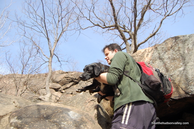
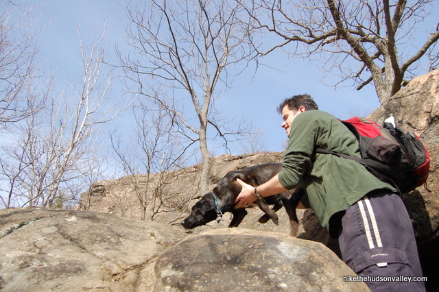
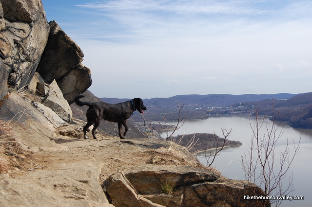
I didn’t see any other dogs there that day, but a fellow hiker assured me that she sees dogs here all the time. There were several spots where my pooch Memphis needed a boost, and I honestly don’t see how a dog would get over some of those spots without being picked up and placed on top of the rocks.
The point I’m trying to make: This hike is steep.
It is also gorgeous and unforgettable. If you have a chance to pay a visit to Breakneck Ridge, don’t pass it up. And if you don’t have a chance, you should probably make one anyway.
**UPDATE October 2014** A friendly first responder reached out to me with this message: “Our local volunteer first responders do a lot of rescues at Breakneck. Amazing how ill-prepared some folks are when they attempt any outdoor adventure.” She recommends that everyone review this list before attempting this hike. Good advice! Let’s make sure your day at Breakneck is memorable for the right reasons.
**UPDATE October 2021** If you’re interested in taking a shorter hike at Breakneck, the Nimham Trail (opened in 2021) offers some great new options. Please see my Breakneck Ridge: Short Loop trail guide if a 1.5-mile loop sounds more like your speed. Or distance. You know what I mean.
Trail Guide
Bonus unsolicited advice: Don't depend on having cell service in the woods - it can be spotty out there! Download this trail guide to your phone before you head out. (It's easy to do on iPhone and Android.) May your connection to nature be strong, even when your connection to the internet is weak.
1. From the parking area by the tunnel (or the overflow parking just north – see “Directions to the trailhead” below), head to the northern side of the tunnel and grab a map from the box at the trailhead. If you’re the preparing type, you can also print this PDF trail map from the NYS Parks dept.
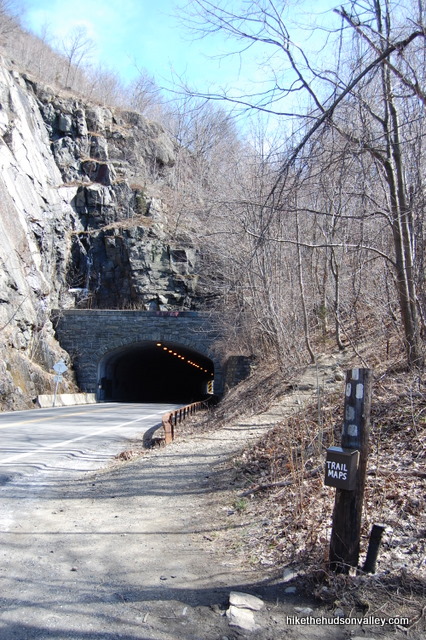
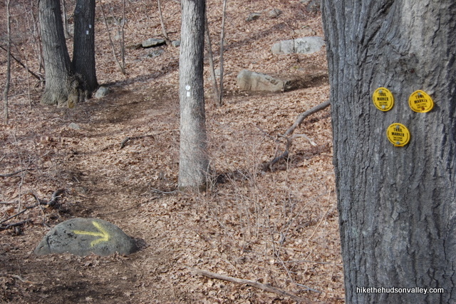
2. Climb up and over the tunnel that runs over Rt 9D, following the White Trail markers.
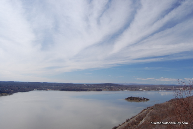
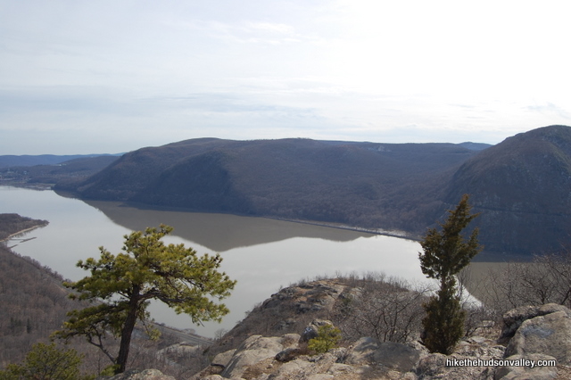
3. Keep climbing. Up and up and up. After what feels like quite a climb (because it is), you’ll come to a flagpole with a great overlook. Across the river is Storm King Mountain. To your right is Pollepel Island with Bannerman’s Castle perched on the side, and the Newburgh-Beacon Bridge beyond. Incidentally, has anyone ever called this bridge the Hamilton Fish Bridge, like it says on the sign as you cross it? If you pointed to it right now and called it the Hamilton Fish Bridge, you’d probably be the first.
4. Enjoy the view toward the river, and try not to think too much about what’s waiting behind you.
Oops, you thought about it, didn’t you? Oh well, might as well start climbing again. Just keep following those white markers.
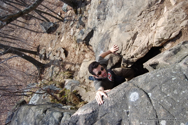
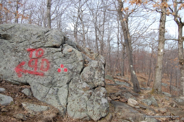
There are a few spots where you can choose steeper or less steep options, which you’ll see marked with an X pointing left and right.
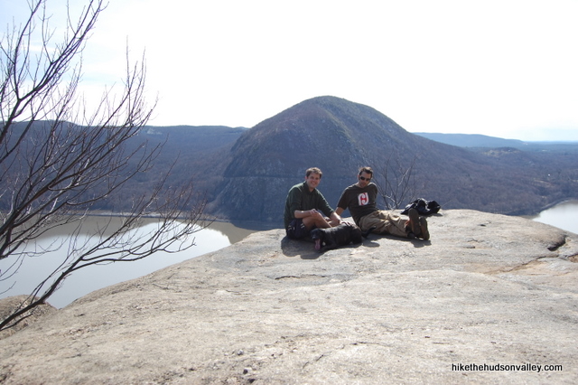
See that guy on the cliff in the picture above? He was heading down, and when he popped out beside a rock to my left (I was looking right – he surprised me), I realized that the trail was less steep the way he came down. That guy saved me at least one dog-carry.
5. Keep climbing, and the flagpole becomes a distant memory.
6. Take some time to enjoy the next cliff overlook.
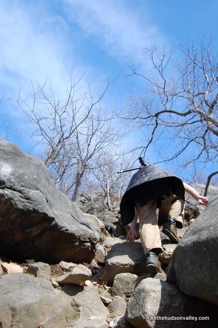
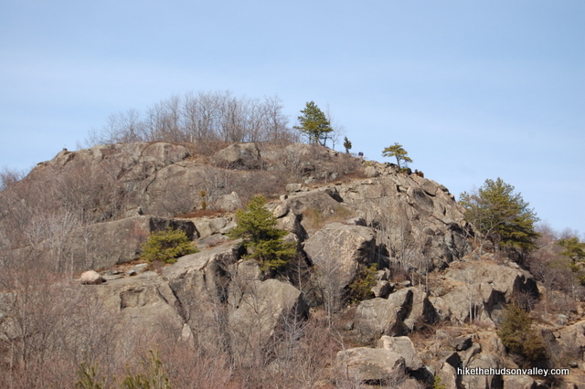
7. Keep climbing, and eventually, this mountain will run out of bluffs to throw at you. Really, it will. When it feels like you’re at the top and you can’t see any more bluffs in front of you, you’re probably there. You’ll have traveled about a mile, though it seems more like ten. The next three miles on the loop fly by in comparison.
At the top, above a couple of nice little pine trees, enjoy the view and munch a granola bar or two, if you packed ‘em.
8. It wouldn’t be a bad hike to just go straight back down the White Trail from here. That’s really where the best views are. Most hikers like a good loop, though, so if that applies to you, let’s keep trekking. (Also, the rest of the loop doesn’t require any dog-carrying. The thought of carrying my dog back down some of those White Trail sections again was enough to keep us pressing forward.)
9. In the small saddle after the last big bluff, ignore the Yellow Trail as it departs to your right. Keep heading straight on the White Trail.
10. You’re looking for a turnoff on your left to the Red Trail, after you pass one last small summit and a little marsh on your right (the frogs were going nuts in there when we walked past in late March – I thought we were coming upon a flock of turkeys. Also, the Internet tells me that I should have said “a rafter of turkeys,” but somehow that seems like the only way to talk about turkeys and be pretentious at the same time.)
The turnoff to the Red Trail is very tough to miss. The only thing it’s lacking is a flashing light, and perhaps some sort of siren. When you see it, take a left.
11. Follow the Red Trail (aka the “Breakneck Bypass”) down a much more gradual descent through the woods, with occasional northerly views of Sugarloaf and the river.
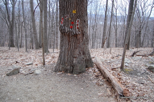
12. After 30-60 minutes, depending on how leisurely you’re strolling, the Red Trail dead-ends into the Wilkinson Memorial Trail, marked in yellow. Take a left onto the Yellow Trail and keep following it downhill.
13. The Yellow Trail continues its gradual descent for 15 minutes or so, ending abruptly and dumping you unceremoniously onto Route 9D, which can be a pretty busy road.
Normally, I hate road hikes, and don’t consider a loop trail that has a large road section to be much of a loop. But you can actually see the parking area from the dump-out point, so we’ll let this one slide, especially since it kept us from having to carry our dogs back down the mountain.
Take a left onto Route 9D and walk carefully on the well-worn path beside it.
14. Carefully cross the street once you get back to your car. Boom! You did it. Congratulations on knocking out one of the toughest hikes in the area. Now find someone to show all your awesome pictures.
Directions
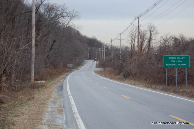
Directions to the trailhead: From the village of Cold Spring, head north on Route 9D for about one mile. At the far end of the tunnel, turn left immediately into the small parking area. If there aren’t any spots there, head north just a couple hundred more yards to find a larger lot on the left.
You can also get directions by checking out the Breakneck Ridge entry on the HiketheHudsonValley.com Google map.
Sorta nearby address for your GPS: The intersection of Fair St and Route 9D in Cold Spring, NY is about a mile south of the Breakneck Ridge trailhead (the parking area is immediately north of the only tunnel around on Route 9D).
GPS coordinates of parking area: 41.44327, -73.97801 (Clicking will open in Google Maps or the Apple Maps app, depending on your browser/device.)
Resources & Interactives
Super-cool Google Earth flyover of hike route:
Google Terrain Map of hike route:
Related resources: If you’re looking for actual facts and/or useful information, visit these pages:
- New York State’s Hudson Highlands State Park page
- New York State’s Hudson Highlands trail map
- Some great preparation advice in this blog post from a Breakneck Ridge trail steward
- Breakneck’s Wikipedia page
- Train schedule for Breakneck’s MTA stop
- Nycdayhiking.com’s very nice Breakneck write-up (and description for a longer loop trail)
- The page to buy the awesome New York-New Jersey Trail Conference map for this area
- Another nice Breakneck write-up from the New York-New Jersey Trail Conference
- My Breakneck Ridge: Short Loop trail guide for a new (as of 2021) 1.5-mile hike option
Want to support trails in the Hudson Valley? Here’s one great way: Visit the New York-New Jersey Trail Conference homepage and click on Volunteer, Donate, or Shop! (Then you can volunteer, donate, or shop, depending on your mood.)
You can still hike this trail, but you won’t be able to park at Breakneck Ridge. You can park at the Washburn Trailhead in Cold Springs, take the Cornish trail -> Undercliff trail or Brook trail -> Breakneck Ridge (white trail). There are a few routes. Cornish to Brook is the shortest.
Another route if you’re up for it would be to park at Beacon. Take the Casino trail -> Breakneck Ridge trail. It’s 6 miles one way to the Flags at Breakneck Ridge.
as i see will the place be closed for two years beginning April 21 2025
Mike definitely covers this by talking about how hard this hike is, but just to make it super clear for first time or inexperienced hikers looking to cut their teeth:
This is a *very* technical hike, and I’d argue not one you should do first if you’ve never really hiked before.
I live in the area and do day hikes 3x a week around here, and every time I do Breakneck I’m reminded by how technical it is, and then shocked by how this is probably a lot of people from NYC’s first hike ever because of the convenience factor.
If you’re going to try it, have good footwear (I’ve seen people recently in crocs… do you have a death wish?!), don’t do it if there’s been any rain recently, and pay attention to markings. Someone got pretty hurt and had to be rescued a few weeks ago because they fell after going off trail.
That said, if you’re careful, don’t mind heights, and follow Mike’s guide, you’ll be fine. It really is a fantastic hike and super fun if you like bouldering!
If you’re intimidated or want something a bit more mellow, here are a couple of beautiful, challenging, but far less technical hikes that you can access by Metro North (granted they’re a little further from the train but not too bad at all). And, of course, Hike the Hudson Valley has spectacular guides for both!
* Mt. Beacon + Mt. Beacon Fire Tower (train to Beacon – one stop past Breakneck with a way more frequent train schedule. Walk to trailhead, get a cab, or take the Beacon Free Shuttle from the train station to the trailhead. Def go to the Fire Tower. Walk back into town after and treat yourself to a beer and pizza at Hudson Valley Brewery.
* Bull Hill (short or full loop) – in Cold Spring, beautiful views, a doable walk from the Cold Spring train station and you’re way closer to cute little Cold Spring when you’re done (Breakneck > Cold Spring is a solid 2 mile walk with a solid ~1 mile of it on a 55 mph highway).
Enjoy your hike!
I always advise first timers not to climb the rocks up. I actually had to stop a grandmother with an infant in her arms from climbing the rocks. Proper footwear and plenty of water are a must.
I’m planning on Mt. Beacon in September or soon as it cools a bit. When I was a kid, we use to go to top in the cable car. Early 1960s. A very different downtown then.
All very true and great advice, Kash – thank you for sharing it here!
Howdy ho!
I come with good news, that the Breakneck Ridge trail updates have been completed on schedule! The trail should reopen with connects to the new Fjord Trail tomorrow, Saturday July 1st!
Happy trails!
Thanks so much for the helpful comment and great news, Max! I’ve updated the trail guide above accordingly, with a link down to your comment. Much appreciated!
Hey Max, have the updates made the trail easier to hike? I’m a novice hiker at best but want to plan a trip here for my husband. It looks intimidating but I read somewhere that they’re working to make the ascent less steep?
Are there any parts in that area rumored to have paranormal activity, or historical sites? I’m a bit of a not-so-typical hiker looking for that kind of stuff.
Hello, Dan! Don’t know about any of that kind of thing around Breakneck, but if you haven’t already seen this article from the New York Times about another local destination with a paranormal reputation, you might enjoy it: https://www.nytimes.com/2010/10/15/nyregion/15hawk.html. Best of luck finding interesting stuff out there!
Hi Mike!
Love love love your website, so much more fun than just “turn left at the big tree.”
Just wanted to point out that the flagpole at the first false summit on Breakneck is GONE! It has been replaced, unfortunately, by some new graffiti, the spray painted word “FLAGPOLE.” But the actual flags are no more. Thought you might like to know since they were such a key landmark.
Also, stay tuned….State Parks will be announcing a new connector trail in the Breakneck area, to open in the coming months.
Thanks for your hard work on this fantastic guide to all things Hudson Valley hiking!
Thank you so much for the kind words, Derin! So glad this site has been useful to you! I’ve recently seen photos of the new flagpole at Breakneck (identical to the old one, I believe?), so that situation has been remedied. You also provided some solid intel on the new connector trail – thanks for the heads-up! I haven’t visited the new trail yet, but it sounds pretty sweet. Here’s a press release announcing its opening (two months after your accurate prognostication) : https://parks.ny.gov/newsroom/press-releases/release.aspx?r=1685. I look forward to checking it out sometime soon. Thanks again, and happy adventures to you!
Your dog is so beautiful. Love your experience
Thanks, Oliver! She’s a good girl 🙂
Is this hike safe if it rains the day before? Say it rains in the morning on Friday, will it be safe to hike on Saturday?
No. Vibram soles don’t grip wet rock very well. This hike is dangerous when wet
If you follow the trail explained above backwards, can you get to the views without the rock scramble? If not, is there another trail that will get you up there? Thanks!
Hi, Jen! Yes, you could absolutely do that. You’d get to the views shown in Step 7 above before you’d hit the extremely steep stuff headed back down the White Trail, then you could just turn around and retrace your steps down the longer-but-less-steep Breakneck Bypass. There are other routes to the top (you can see the Hudson Highlands trail map linked in the “Resources” section above), but your proposal is a good way to do it. Good luck if you give it a go!
Is it appropriate to eat at a restaurant after hiking? Me and my group are planning to go to a restaurant in Cold Spring after we’re done hiking, but some are worried it may be unhygienic and repulsive to the community. Any thoughts? Any feedback would help me and my friends feel comfortable with the idea. Awesome article by the way!
Hi, Jovan! In normal times, that would be such an easy question! That’s really nice that you’re thinking ahead and worrying about what locals would prefer. You’ll likely find a wide range of opinions on this topic, and I know it can be a hot-button issue locally. Not living in Cold Spring, I’m not the best person to offer advice, but I would expect that as long as you are respectful of the place you are visiting, follow all appropriate mask-wearing and social-distancing guidelines, you should be okay. Personally, I’m still only comfortable doing takeout, though I hope that New York’s re-opening can continue to be managed in a way that lets us safely resume some of these activities that we used to take for granted. I know I haven’t given a definitive answer here (nor should I, really, since this is such a personal decision), and I welcome thoughts from others if anyone else would like to share. I wish you and your friends all the best!
Jovan, if you’re worried about bring sweaty and stinky in the local restaurants, don’t be. Hikers pretty much fuel the economy in Cold Spring and the locals are used to us and now are welcoming us back.
Is the Breakneck Ridge metro-north station open on weekends? Me and a group of friends are planning an early trip to Breakneck by rail during the weekend, but the MTA website says that the Breakneck Ridge stop is closed until further notice. If it’s totally closed, we’ll take an Uber from Cold Spring station (the station before Breakneck Ridge Station) which costs about $10-15. Any feedback will be greatly appreciated and helpful!
Normally, it would be. But if they tell you it isn’t, then I guess it isn’t. I’m curious to know if trains now run to Cold Spring. If they do, you can hike the road from Cold Spring to Breakneck. I’ve done it many times and followed the blue or yellow (shorter) trail back to Cold Spring after the ascent. The hike on the road is actually remarkably picturesque. Of course, doing it on a crowded weekend puts a damper on the entire experience (at least for me).
Hi, Jovan! Over on the “Closures” page, friendly hiker Izabela reported speaking to an MTA employee who told her that the seasonal hiker stops (including Breakneck, Manitou, and Appalachian Trail) may not open again until September. At that time, I couldn’t find anything on the MTA site, other than an error when you try to search for train schedules at those stops, but it sounds unlikely that you’ll find those stops open anytime soon (and now I see the “temporarily closed” notice on the website, which is an improvement). Sorry I don’t have better news! Here’s a link to Izabela’s comment: https://hikethehudsonvalley.com/hudson-valley-trail-closures-and-parking-restrictions-due-to-covid-19/#comment-7597.
So I am a little confused about what hikes are open or closed. The official answer seems to be closed but are the hikes open? Is there any where to park? Thanks.
Everyone should be concerned about Covid 19 especially when crammed on a single path trail with thousands of others in such close contact. Also because everyone has to touch the same surfaces to get to the top. This area was being destroyed before the outbreak and now is in its final death knell. Too many people are visiting and obviously don’t care about the spread of the virus or anything else for that matter. The population of Philipstown doubled last weekend with a careless visitors crowding into every portion of the Town. This puts all the residents who have been sheltering in place in danger and empties out our only market. Please consider hiking somewhere else for the time being. This Town and the environment need time to recover. If you care about the Hudson Valley give it a rest.
is it safe to hike this trail now? is it still crowded?
Hi, k! The trail is open now, though parking is still greatly reduced. And yes, Breakneck is still very, very crowded on weekends, and I would recommend not attempting it on a weekend unless you get there VERY early. Would be a wonderful hike to do on a weekday, though!
I sneezed on the trail holds by accident
Went for a hike this Saturday and Sunday. It was very crowded. Any thoughts on whether we should be concerned about Covid 19? Especially the start of the white trail where everyone is touching the same rocks, sweating, sneezing etc.
Dan, that’s a fantastic question. Breakneck is one of the most popular trails in the country (THE most popular, by some accounts), and while hiking is one of the few activities that’s still available to us outside of the house during this time of social distancing, I’d probably only visit Breakneck at an off-peak time, just to play it safe. As it so happens, the New York-New Jersey Trail Conference just published an excellent article on this topic, and the article specifically mentions Breakneck (with the recommendations to visit at off-peak times, not to visit at all if you are having any symptoms of illness, and to always maintain a safe distance from other hikers). That article can be found here: https://www.nynjtc.org/news/how-hike-healthy-responsibly. Hope you find that to be a helpful resource, and thank you for bringing up this topic!
Thanks, that article is helpful.
What is not covered in the article is the particulars of Breakneck and I haven’t seen it covered anywhere else. When hiking up the white trail (the most common route) it is necessary to touch the rocks to climb up. Also there are certain rocks that almost everyone passes and touches when going up that route. So there are two issues. One is that you have to touch the rocks and the other is that you are touching the same rocks as others. Presumably if someone has the virus they will be shedding it on those rocks! Personally, I’ve been wearing gloves mainly to remind me not to touch my face. No matter what I avoid touching my face.
Breakneck trails are reopened as of Saturday
3/14/20. Cheers and stay safe out there.
Thanks so much for the heads-up, P! That was incredibly fast to get the trails opened back up again. I’ve removed the warning and linked to the notice from the New York-New Jersey Trail Conference above. Really appreciate you dropping this comment here – cheers to you as well!
Glad I can help in any way. Thanks for maintaining and always being on top of things on this wonderful site!
Is the hike safe for not experienced hikers?
That is a tough question to answer. It also depends on whether you are in physically fit, because it can be a rather strenuous hike. The start of the white trail (starting near the tunnel) is a rock scramble with a significant elevation gain. Some people have some difficulty, especially as you get closer to the first peak at the flag. I personally would not recommend the hike to inexperienced hikers. There are many other trails you can try in the area, like Mt Taurus, which starts a couple of miles before Breakneck.
We are considering doing this hike on Friday, considering that Thursday will be a heavy rainy day. But they’re predicting sunny day on Friday. Would you still recommend the hike for an athletic beginner ?
Thanks
Sure, by Friday the hike should be great. Usually the mountain on the uphill dries up pretty quickly. Are you concerned about it being slippery because of the rain?
Correct, since it might be raining the whole night I’m afraid that rocks can be slippery in the morning. Thanks
Saw your comment too late. How did it go? I expect that it was fine.
so i am now a little confused. Is the trail totally open from the normal entry point?
The main trailhead above the tunnel is still closed as of 5/11.
So what’s the best way to do breakneck and get the most of the rock scramble part?
The trail is opening again! https://www.lohud.com/story/news/local/2019/05/16/breakneck-ridge-trailhead-reopen/3698684002/
Thank you so much for the walk thru. It really was a great experience! We went this morning when it was about 64 degrees with barely any people around. Also, don’t worry payment was provided on the trail by a few bottles 😉
Sounds like you hit it at the right time, Kelsey! Glad you had a great day out there! And thanks so much for providing payment — let me express appreciation of behalf of everyone who won’t have to look at that litter now. THANK YOU!!! 🙂
This should 100% not be a public hike. While the hikes nearby are fine, the section that is the uphill scramble that lets off from MTA is incredibly dangerous. Today we saw one boulder the size of a small car and another boulder the size of a bicycle get dislodged and fall. No one was hurt, but when we approached the parks department, they said they know of the problem but can’t do anything because the MTA owns the section off the Breakneck Ridge stop all the way up to the flags for the initial scramble.
The MTA should be ashamed for letting this be open without doing stabilization work on it. The hikes nearby are beautiful otherwise, but do not hike this section of the trail.
Yikes! That sounds like a really frightening experience, HB — thanks for sharing the warning here! I forwarded this comment to a NYS Parks trail coordinator, who sent it to the park managers at the Trail Conference. If I hear anything further, I’ll post it here.
Well, I heard something further! The trail is now closed, and the trail guide above is updated accordingly. Looks like the parks department is taking action! Thanks for posting here, HB, and I’ll do my best to keep the trail guide updated with the latest.
Did you actually see the boulder in the process of falling? Was it raining during that time? Can you explain exactly what you saw? I am amazed that such a big boulder moved and would love to hear more details about it.
This is odd. I hiked Breakneck Ridge on April 25th (getting off the Metro-North at Cold Spring, then walking to Cornish, Brook, then through the tunnel to the beginning of the scramble and finishing the trail in Beacon) and I didn’t notice any blockage on the trail, nor did I see any warning notices. Was there a second rockslide after April 13th that finally shut down the trail?
I noticed the boulder sometime around the first or second week in April. Apparently HB saw the boulder sliding on April 13th. The trail was not closed until April 26th, so if you went on the 25th it would not have been closed yet. Nothing changed from the time the boulder moved to two weeks later when the trail was closed. I guess an official saw a post about the boulder and decided to close the trail.
I hike the trail almost everyday, so I was able to notice the big boulder was “out of place”. It does not block the trail and if you went an alternate way up, you can miss it altogether.
I’d love to get more information about who closed the trail and on what basis. All the news reports are incorrectly reporting the who trail is closed, but only the section from the entrance at the tunnel to the yellow trail is closed.
Thank you, Dan!
I was hoping to find more information myself. The comments here have been far more helpful than any of the news sources. Good to know we can still hit Breakneck from Washburn and Undercliff, although the best parts are closed.
Thank you all!
My own opinion is that even the closed area is safe enough to hike. I’ve been hiking almost everyday prior to the event and since the event and after the “closure”. The hike is actually no more dangerous than it has been for several years now.
Breakneck from beginning to end is my all-time favorite route. I’ve only been up twice this season and I didn’t feel there was any safety issues, but HB’s account is a bit alarming.
Thanks again, Dan.
Mike,
Thank you for sharing. This did save me a lot of time of finding the entrance and trial sign. I went for the hike on 12/30. The route is still open, but be careful for the snow and water. I have to say be careful while descending with yellow trail. It’s harder for me to trace the marks since some rocks are covered by snow. However, the view with snow is breathtaking.
This is really helpful — thanks for the update on trail conditions, Jessica!
This hike should be closed to the public! Today on the beginning of the trail we experienced a HUGE and scary rock slide. Car sized boulders falling. Thankfully no one was hurt but very shaken. We altered the parks department and said the first part of the hike is owned by the MTA and they won’t stabalize the path. Do not climb the any portion below the flags until this hike is confirmed as more safe.
Wow. Never had any issues. Thanks.
Is the hiking still open? When will it be close for renovation?
Greetings, Kar! The renovations are postponed until further notice. I haven’t heard any word on when a potential closure may occur (and if someone reading this knows something I don’t, please share!). Otherwise, be prepared for icy, snowy, slippery, and dangerous conditions this time of year (micro-spikes or something more substantial should be required equipment), and happy adventuring!
Did this hike in the morning (solo). Trail guide was totally on par, thanks Mike! During the ascent there were a few moments where it was hard to find footing, upper body strength maybe a necessity for some. As others have warned and noted, this is a steep hike and definitely not for beginners. The descent was also challenging as leaves covered up rocks that were glazed over with ice/frost. Had a couple of slips but nothing trekking/hiking poles or a random off the ground stick can’t help you tackle.
Did my good deed by picking up a few plastic bottle caps and a granola bar wrapper. Deposited them at the Metro North station garbage cans when I got on 9D.
Thank you to Mike for providing the guidance on all these trails.
Basic, your comment made me smile — glad you had a great visit, and thanks so much for helping to clean up the trail!
Just a word of advice for anyone hiking for the first time: bring lots of water and snacks. I hadn’t hiked in a while and went into the woods with only two bottles of water, an apple and one power bar thinking I would do a short loop to get the feel of it again. Lost track of time and where I was and didn’t get out of the woods until 5 hours later. Ran out of water and food halfway through. No fun. Now I carry as much water as I can carry.
Did anybody get hurt on that trail that you heard on breakneck rigge
Just went this past weekend with my wife and friends. So we have never hiked before, let alone climb rocks and so this was definitely an eye opener. The warnings from the beginning tell you its for experienced hikers only, and yes, i do agree too,but i also think first timers can do this trek as well.
You must be fit though. That is for sure. You will struggle and hurt yourself if you havent been to the gym in ages. I dont mean to scare anyone but there are lots of time you need to use upperbody strenght, balance and great eyesight.
*** warning… the most challenging part of this hike is honestly within the first hour *** holy crap, as soon as you start the hike, it doesnt slowly pace higher, its like challenging right away. good news is, after that steep hill up, its gets easier (after an hour and half worth a climb).
No offense, but if you are a heavyweight, do not do this trek. You need to be in somewhat good shape and you need to dress comfortably. Wear GOOD SHOES !!!
I’m travelling from the UK 28-31 Sept. Are there any local guides to help me with Breakneck Ridge? I’d also like to do a kayak tour to Bannerman Castle – any suggestions on the best place to stay to do both (will probably need to use Ubers/taxis/buses to get around…)
Thanks
Michelle
Hi Michelle! If you visit Breakneck on a weekend, the excellent trail steward from the New York-New Jersey Trail Conference will be on-hand to provide advice (more info on that program here: https://www.nynjtc.org/stewards),
Buried in the comments below, you’ll also find a discussion where one hiker reported having a positive experience with some a local guide outfit that runs trips from NYC (perhaps they could offer advice on Bannerman, too?): https://hikethehudsonvalley.com/hikes/breakneck-ridge/#comment-1567
I’m not well-versed on the best places to stay in the area, but you couldn’t go wrong staying somewhere in Cold Spring – it’s a really nice, walkable town to explore.
I hope this helps, and I hope you have a great visit to the Hudson Valley!
I’m not a guide, but I’ve done it a dozen times and plan on doing it again in the next 3 weeks. I’m putting together a small Expedition, but I don’t think it’ll be ready to go this weekend. I wouldn’t mind doing it before my Expedition.
I love these trail guides! So detailed, and informative.
Tell me about these rock scrambles on Breakneck… I did the rock scrambles on Brace Mountain II (south Taconic Trailhead), and though it was terrifying, I did it! How does Breakneck compare to that in terms of difficulty/steepness?
Thanks so much, Liz! Congrats on knocking out a very tough hike on Brace Mountain! In terms of difficulty/steepness, these two hikes are quite similar. Breakneck’s scrambles go on much longer, though. The scrambles on Brace are over pretty quickly. The scramble on Breakneck is, well, pretty much the whole thing, at least for the ascent. Hope that helps!
Went Hiking with my husband July 30th 2018. Prior to the hike I read reviews and was taken aback at how crazy intense the hike sounded. When we started the hike i was surprised that it wasnt as difficult as it sounded. Getting to the flagpole was amazing and from that point on we hiked with 3 other ppl that we actually met right before hiking up (Z, Jen & Dan). It was a great hike and a lot of fun with amazing scenery. There is easier routes to take but it adds time to the overall hike. We did get lost at one point but Dan google mapped us back on track. In total the loop took us nearly 4 hours. So worth it!
Beautiful and amazing photos of the scenery, what is the average time it took you to complete the trail?
“There are a few spots where you can choose steeper or less steep options, which you’ll see marked with an X pointing left and right.”
I’m a bit confused- to the Xs point the way to steeper or less steep options?
Love the write-ups, thanks!
Most of the easier ascents, if not all of them, head left and are labeled with a white sign that says “easier ascent” or something like that.
Hi….Thanks for this site. Is Breakneck ridge closed yet? I’d like to go there May 13th
No. They postponed it again. Enjoy your hike!
We will be there last weekend of June, Hopefully it will still be open
It will be! See above for an update — the trail will remain open through all of 2018. Happy adventuring!
Hello. Anyone know the current trail conditions?
Thank you!
The NY-NJ Trail Conference has not issued any updates, so I am assuming the trailhead is still open. Given trail condition updates I have seen for nearby areas, you need full winter gear (heavy-duty spikes/crampons, probably an ice axe, etc.). After yesterday’s storm, that trail is probably an ice chute. People in some of the hiking groups on social media were having trouble nearby with just microspikes before this storm hit.
Thanks a lot. I only have crampons (no axe). Now I need to decide if it’s worth the 2 hour train ride to see if it’s possible.
Its almost spring time. Any updates?
I’m waiting for updates too! Anyone?
Brand new update as per the NY-NJ Trail Conference guys!! It will remain open though 2018!
http://nynjtc.org/news/protecting-north-americas-most-popular-hiking-destination
Thanks so much, Francesco! This is really helpful information!
Hey Mike just wanted to point out that I just found out that Breackneck Ridge is not yet closed, and won’t be until Spring 2018! This is according to the NY-NJ Trail Conference. Im so excited to be able to go do this trail again it is my favorite so far out of the many hikes I did, my first time here I accidentally went all the way to beacon mountains fire tower and down beacon mountain for a 7 hour hike, it was my second hike ever!
Thanks so much, Francesco! I just updated the alerts above to reflect the most current information. If anyone finds anything more current, please clue the rest of us in! Thanks, all!
Does anyone have any experience doing this hike loop in the opposite direction from what is described here, namely ascending from the northern 9D access point, hiking clockwise, and then descending to the southern 9D access point? From topo maps it appears the ascent might be less steep but the descent might be a bit more treacherous. A worthwhile trade off?
Thanks, hikers!
Breakneck to Close for Repairs – http://highlandscurrent.com/2017/09/15/breakneck-close-repairs/
This is not good. Will the other hikes in the area be closed? Does anyone have any idea for how long?
Hi Mook — looks like this is pretty well contained exclusively to Breakneck. I posted another article at the top of this page that provides more detail. Annoying in the short term, but should be a very good thing for the area in the long run.
Andrey, thanks so much for sounding the alarm! (I also thanked you in a Facebook post on September 15, which caused a bit of a stir as word starting getting out.) I’ve added a SUPER-MEGA-UBER ALERT at the top of this trail guide. Really appreciate you posting this here!
My coworkers and I are planning a hike here in 2 weeks. A large group of us are first time hikers, and we were told that this is a doable hike for us. Do you recommend this mountain for people who have never hiked? Can it be done in sneakers? Thank you!
I would do Bull Hill instead. Falling leaves can make this slippery. And if you have just one person who freezes halfway up, turning back isn’t really a very good option. Hopefully, everybody’s fit. You can do this in sneakers but they should be relatively new (sole tread) and high quality.
I generally hike in sneakers. Heck, I did Mount Marcy, 3 other Adirondack High Peaks, and 4 Catskill High Peaks in an old pair of sneakers that’s too muddy for daily use. That’s not an issue (unless you don’t want them to get muddy) and, unless conditions are very slippery, sneakers are probably better because they’re lighter than boots.
That being said, this is easily the most technical hike in the Tri-State and one of the most technical common hikes in the state that doesn’t require the use of special climbing equipment. Two free hands are a necessity and, once you start climbing, the easiest way down is to continue climbing to the summit (roughly 1,200 feet of ascent) and head down the side. If anyone is remotely afraid of heights, would not recommend this hike, as you’ll have a problem if someone freezes. Ice starts to become an issue this time of year and the hike is generally in the shade until afternoon.
If you’re reliant on transit to get to the trailhead, Bull Hill and the Cornish Estate are nearby and within walking distance of Cold Spring. Anthony’s Nose can be accessed from Manitou (also really good views, but easier and not particularly technical). If you’re driving, Storm King (across the river from Breakneck Ridge, parking on the NB side of 9W) is relatively easy with great views and Mount Beacon (a few miles north on Route 9D) has great views with similar difficulty.
I wouldn’t start with breakneck – it’s a pretty tough hike. Mount Beacon is a better bet for newbies. Still strenuous but not crazy hard.
Did this hike today (a Wednesday). While the parking lots filled up, I got there early enough to avoid craziness hiking up and it appeared that most hikers either turned around at the flagpole or returned down the yellow (Undercliff) trail before reaching the summit. The signs at the trailhead don’t lie: this definitely is “NOT a walk in the park”, but it’s not particularly tiring, as the immediate rock scrambles force you to set a slow pace. A little over a mile from trailhead to summit and it’s mostly rock scrambling. I’m a 22 year old in decent shape and the loop took me 3 1/4 hours, including a stop at the flagpole and lunch at the summit; 2 hours of that was the ascent. A few notes I’d like to add:
– Two separate “X” trails. The first, shortly after the flagpole, has “EZ” spray-painted on the rocks to make it easy to find. The second, closer to the Undercliff junction, has a green “Easier Ascent” sign pointing the way.
– The true summit (1260 feet) is two peaks after the Underhill trail breaks off, roughly 1/4 mile before the red junction.
– The red trail turn immediately after the white-red junction is still poorly marked, but the well-worn unmarked trail appears to be “official” per the park map
– Both junction turns (white to red and red to yellow) are VERY well marked, with “9D” and an arrow painted at both. First turn also has an official sign.
– For people who like knowing where they are, the state parks department put the map on the Avenza Maps app. Download the app and search for “Hudson Highlands North”
Thanks so much for the helpful updates, Josh! Glad you had a great day out there. (And I’ll second the plug for the Avenza Maps app — just used it for the first time on a different hike, and it is really great to know exactly where you are at all times.)
hi Normally we do the W-R-Y path and it takes about 2 hours. If we want to go longer would we then do the W to Blue/white (dont turn at the red and then come back down the yellow)? How much extra time do you think that will take?
Hi Michael — I’ve never tried that route, but it looks like a nice option if you’re looking to do a longer hike (W-BW-B-Y(left)). From the map, it looks to at least double the length of this hike, but the terrain shouldn’t be as gnarly once you’ve gained the initial elevation. My irresponsible, shot-in-the-dark guesstimate: 6.5 hours total, or 2.5 additional hours onto however long it takes you to do the W-R-Y version. Let me know how close I got if you give it whirl! 🙂
I am planning to tackle this hike this sunday, but looks like it will be raining on friday and saturday. Anyone know how the conditions would be after 2 days of rain. Would it be safe enough to attempt?
thanks!
Selling hot dogs at the tunnel is great
Stop by to say hello !!
Sept 8th 2018
There a run on the ridge ♡
I was told ♡
Hope to see you there ♡
Good luck to all who runs ♡
Dawn gone good hot dogs
Yesterday, I rode Metro North to Cold Spring and walked to the Breakneck trail head. Kind of a long hoss but not that bad really. And the views are nice along the way. Once through the tunnel, I took the white trail past the cut off and turned right on the Notch Trail (blue)…then the red trail and to another blue trail (Cornish) and all the way back to Stony Point where I spent a last hour exploring there. This is doable. For people considering taking the train to Cold Spring…you can walk to Breakneck and forgo the cab. I’m a healthy 66 years old and not even sore today. And of course, the views are multiple and spectacular. And there’s even a doozy AFTER the cutoff you’ll miss if you take the short version of the hike.
Thanks for description of the trail. My 18 yr. old son wants to take some friends there, so I wanted to check it out. Looks amazing!
Hiked Breakneck for the 20th time yesterday with a friend from Kansas. Could not wait to take him on this hike because of the view and degree of difficulty of the hike compared to how flat Kansas is.
I was appalled at how much trash there was on the trial and worse yet, all of the graffiti on some of the rocks. I was embarrassed to have a guest hike this beautiful place with me. We picked up as much trash as we could to throw it out when we got off the mountain.
First, from a local: thank you. Lots of us carry garbage bags as a matter of course, especially on Mondays. It’s depressing.
Worse now is the proliferation of graffiti. Robust discussion locally, but I seriously wish the parks department would step in.
Beautiful and challenging hike. Major gripe is heavy crowds, severely eroded breakneck ridge and wilkenson memorial trails. I hiked from breakneck to beacon back in 05 on a holiday weekend and not seeing that many people along the way. 9D wasn’t lined up with cars when I finished my hike like you see today.
Go early and go often…
Hiked Breakneck today for the 2nd time this season and it was absolutely beautiful out. The first time I hiked this trail I was with the LADY! and about 100 other people who decided scrambling up the face of a mountain would be a good idea. While the firt trip up was great, having to wait for others to find their next move, and also having to navigate around people who decided they wanted to stop and look out at the Hudson before even reaching the flagpole, was frustrating at the least. I planned it better this time and got to the trail before 8am.
I was one of 6 cars at the trail head when I arrived, and did not see anyone else on the trail till the 2nd lookout. It was absolutely beautiful. The Scramble is difficult. There are parts where it is fairly easy, but then there are parts where you will seriously hurt yourself if you lose footing or are scared to get your hands dirty on some mossy rock. While my first trip here didn’t feel as difficult as today, I think part of that was that I subconsciously followed the people in front of me, and was able to see where they grabbed and stepped.
Since I was alone and there wasn’t hardly any traffic, I was able to take a few moments on a few of the payoffs to just sit down and look out at the hudson river. It was also fun looking across the way at Storm King thinking “a few weeks ago I climbed that mountain and was looking back over here at Breakneck…”
The way down wasn’t bad, but it was a bit slippery since there had been some rain last night.
All in all, I ended up seeing 3 people and a dog at one of the most popular hiking spots in the hudson valley, and was able to get in nearly 4 miles and a nice rest on the payoff in 2 and a half hours.
When i was walking back to my car, the masses were finally starting to arrive and hit the trailhead. It made me really happy that I got up early rather than sleeping in.
Hello guys,
I like to check out the map before I get on the trail. Which state park should I be checking out the map for which includes this trail? Thank you a bunch.
Yuliya,
Man, keeping the links on this site current is tough, especially when New York State switches its URLs around every year or so, just to keep me on my toes. I’ve fixed the links above so that you no longer need to know which park to select – the links will take you right to a PDF trail map, just like they used to do. (See the map link in Step 1 of the trail guide, or in the Related Resources section.)
Hope that helps – thanks for the alert!
Mike
I’d like to go for a day hike from NYC but I’m without a car. Is it possible to come from Grand Central Station to Cold Springs and get a taxi from there to the trail head? Otherwise, is walking from Cold Springs train station to the trailhead the only other option?
Thank you!
There is actually a stop at Breakneck Ridge a handful of times per day. Check the MetroNorth schedule to see the times. My buddy and I took the train there, hiked the trail, and ended up in Cold Springs, where we caught the MetroNorth back.
We went here yesterday with my staff thinking we were doing the other one thats 7 rated. So we werent full prepared. Had some friends too so we were 13 in total. One of my friends had a broken foot and had to do the whole thing with a stick. It was hard but he is happy he did it. We really enjoyed this hike and want to do it again. With proper planning of course.
We love your site. How much longer does it take to keep going up the white until it runs into the yellow.
Another words skip the bypass? Thanks again
Hey Mike,
I noticed you said your friend got to the trailhead from the cold springs station. Is that an easy walk? I’m looking to do Breakneck this Friday but not sure that the Breakneck station is open that day, and looking for an alternative…
Hi. I walked from the station to the trailhead before. I believe it’s around a 2.8 mile-walk. Easy on the way there but horrible on the way back especially if it’s hot. But overall, it’s fine. Hope this helps!
Thanks for the info, G! Chase, as G said, it would not be an easy walk. Possible, yes, but not easy. My buddy cheated by having me pick him up, and I drove us to the trailhead. If Uber isn’t already in Cold Spring (I’m country folk, so I have no idea), seems like a ripe opportunity there. You could probably make a living shuttling hikers from the Cold Spring station to the area’s various trailheads.
I just checked Google Maps, and G’s estimate looks about right — around 2.5+ miles from the train station to the Breakneck trailhead. Good luck and enjoy, however you get there!
Thanks Guys! I think I’m going to try and find a cab or uber from the CS station. Thinking of doing the white ridge trail up and taking the blue notch trail back to either the red to blue or yellow trails back into cold spring for a rewarding beer and burger. Any suggestions of which of those two trails to take (R or Y)? Any special sights? I see ruins on the map..intriguing….
Thanks Guys! I think I’m going to try and find a cab or uber from the CS station. Thinking of doing the white ridge trail up and taking the blue notch trail back to either the brook to cornish or washburn to undercliff trails back into cold spring for a rewarding beer and burger. I see from a comment below that we have a few manageable options, but if there are any sights along those trails you recommend, please let me know!
Thanks again!
Hi. Thanks again for your wonderful trail guides. Ive been to Storm King, Lake Minnewaska, Anthony’s Nose, Bull Hill, Mt Beacon, Bonticou Crags and Table rocks, Sam’s Point, Little Stony Point, Walkway over the Hudson and Croton Gorge Park all because of your very helpful guides! Ive been to Breakneck as well but i wanted to know, how do i find that old eerie tree? I know its weird but id love to go visit Breakneck Ridge again just to see that tree hehe!
That’s quite a list, Ceem! Awesome! That’s really great to see – glad the site has been useful for you.
As for the tree (I assume we’re talking about this one from the slideshow?), it was photo #512 from that day, and the photo in Step 12 above, showing the turn onto the Wilkinson Memorial Trail, is #514. Given that I take about one photo every ten seconds out there, I’m guessing that old tree is somewhere very, very close to the turnoff. (My buddy Rob noticed it – have to give him credit.)
Hope that helps! You’ll have to share your own pic after you find that tree 🙂
Oh my, I feel terrible about not being specific about it and you had to go thru the slideshow. I actually saw the picture of the tree recently on Hike the Hudson Valley’s Facebook page but i couldn’t find it anymore. I have seen many others post that picture but no directions at all and I feel like I should go there too haha! Anyways, attached is the photo of tree I was talking about. No pressure though. It might not actually be along the trail. Thank you!
Oh, of course! Yes, that tree is on Sugarloaf, right next to Breakneck. At the junction near the other not-as-cool-spooky-old-tree, instead of turning left to descend on the Yellow (Wilkinson Memorial) Trail, you’d turn right to ascend Sugarloaf.
That old tree is a local landmark – anyone who chooses to visit, please treat it with respect! (I know you would do this, Ceem, but I did accidentally share a photo of two people sitting in the tree on this site’s Facebook page. I thought they were branches when I glanced at the otherwise stunning picture on my phone. When I looked at a bigger screen and realized what was going on in that shot, I deleted it from my Facebook timeline, which is probably why you can’t find it there anymore. That tree would surely not survive being treated like that for long, and it would be a real loss if that thing came down.)
Hope that helps!
I know. If that tree doesn’t survive, people like me might not have a chance to see it anymore! And thank you for letting me know where it is! I will visit it next week. Thanks again!
which of those was your favorite?
Great site. My wife and I have done Anthony’s Nose, Storm King Mountain, and Bull Hill using this website this spring already. Also have done the Major Welch trail in Bear Mountain. How much more difficult is Breakneck than these? I really want to do this and we’re in great physical shape but don’t want to underestimate. Thanks!
Dave, that’s awesome! Glad the site has been useful for you. Breakneck is comparable to the steepest parts of Storm King — I expect you guys won’t have any issues, but I gave this one a 10 out of 10 difficulty rating so people would take it seriously. Happy adventuring!
Great Article. I always follow your articles before hikes :). Wanted to share few thoughts on the trail guidance. There is a parking after the tunnel ( following 9 D North) and its close to the trail entrance. This is the overflow parking as you mentioned.
There is also another parking much before that tunnel.I started with this trail first ( white trail) . This trail it made a turn and started going towards south away from the Overhead pass. I was not sure if I was on right track. I came back and then too k my car and went to the “Overflow parking area”. I guess you entered from this entrance. Does this trail goes back to the trail from the Break neck ridge entrance ( which is near the tunnel? Google map has a link to the trail entrance called Breakneck Ridge Trailhead. This is near Tunnel. Which one did you take?
Hi, Maloy! I parked right next to the tunnel – I took a vacation day and did this hike on a weekday, so there were spots available there. The overflow parking is just a little further north. Not sure about the other trail you’re mentioning – I’ll have to look for it next time. Sorry I can’t be more help on this one!
Pingback: Romance in the Hudson Valley ~ Dogs too!
Pingback: Hiking: Breakneck Ridge, Hudson Valley New York (Phone pics) | life on macro.
Last did this hike 25 years ago. Wife and none of my out of shape BFFs are interested. Too bad. Spectacular views, challenging climb and an hour outside NYC. It is a SCRAMBLE and at times will need all extremities to achieve solid hand/foothold. You don’t need to do technical climbing for the harder (non-alternate) route but you should be very experienced or at least go with someone who is so you can be leveraged ever upward. Light gloves are good idea. Plenty of water (amazing number of folks going up with no fluid replacement). The cardiovascular challenge will have you sweating at 40 degrees F within 15 minutes so bring lots of easily sheddable layers if you want to be dry on the level and descending part of the hike. And the initial descent on the uneven Red bypass trail in late fall covered by leaves can be particularly challenging. A good collapsible pole would be valuable here. And above all take your time. Start early enough…you want to budget comfortably 3hrs for traditional loop white-red-yellow-9D loop unless you want to be the object of ridicule (or worse) by the Cold Spring Fire and Ambulance crew.
City hikers – please use common sense when taking a trip up here from Brooklyn to hike. This is an incredibly dangerous and difficult hike. Please bring proper boots, proper gear and a map/compass. We love the visitors, but tire of our FD and amulence corps volunteers having to go out on calls to find lost hikers every weekend.
Hey Mike,
So, I got in touch with Chase at Xcelerated Adventures for my tour. There was a group of 12 of us and he was an AWESOME guide for this hike. For people who are not seasoned hikers but want to do something challenging like this, I think its super beneficial to do it with a guide. Chase was amazing! I’d highly recommend his company for these tours.
Amazing!! Thanks so much!!
I want to do the hike with a few friends this weekend. Does anyone know of an individual or company that offers guided tours for Breakneck Ridge?
Hey Justin — I don’t know anyone who has used these guys, but they reached out to me earlier this fall, and the site and write-up look pretty solid: https://yourguidetoadventure.com/adventure_travel/breakneck_hike_nyc
The bottom of the page says that their guided tours of Breakneck are closed until April – seems like unfortunate timing. Might be worth reaching out to them, anyway. Hope that helps!
Mike, thanks so much for putting this website together. It has been extremely informative when planning hikes in and around the Hudson Valley.
I am looking at hiking Breakneck Ridge this weekend and we’ll be taking the train from Grand Central. I was thinking about starting at the Breakneck Ridge train station and ending in Cold Spring to take the train back from there. In looking at the map, we were thinking of taking the Notch trail after the ruins and then taking the Washburn trail down to Little Stony Point to get some well deserved food in Cold Spring. Since we won’t have a car, we don’t need to do the loop, so thought about mixing it up. Have you done this version? If so, any idea of the distance and time on this trail? Much appreciated, Mike.
Jeff
Hi Jeff! I’ve never done that route before, but on the map, it looks doable, assuming you are in really good shape and up for climbing both Breakneck Ridge and Bull Hill. From the ruins to the Bull Hill parking lot (taking Notch Trail to Washburn Trail), it’s about 3 miles, going straight up and back down the mountain. A tamer option would be to take the Red Trail (Brook Trail) from the ruins, then down the Blue Trail (Cornish Trail) back to the parking lot, which completely avoids climbing Bull Hill. The good news is that you’ve got options — you can see how you’re feeling at the ruins and decide whether to tackle Bull Hill or not. Sounds like a great day either way — hope you enjoy it! (Update: My original comment misstated the elevation change and total distance — the Notch Trail doesn’t go over the summit of Bull Hill, but it comes pretty close. The total distance from the ruins to the parking lot would be just over three miles (not four, as I’d originally said) going Brook (Red) Trail -> Notch (Yellow) -> Washburn (White). Sorry about that!)
Woot, finally made it out to the hike and it was great. A little nerve racking as we never rock scrambled before and we got a little frazzled at the end trying to follow the yellow train connected to Fire Tower lane (beware, a few trail markers are on downed trees and some sections near the small stream can get you lost). Will be making this trip again.
On a side note, on the listing of trails, would it be possible to add a list of hikes that can be reached without a car? Will be looking forward to go on more runs. Thank you.
Gabe
Glad you had a great day out there, Gabe! I’m not an expert about getting around without wheels around here, but that sounds like a great topic idea for the forum. Okay, I just posted a topic there to get it started – hope other people will chip in some winners! http://hikethehudsonvalley.com/forum/hiking-without-wheels/
Mike,
Thank you for creating the topic, will keep an eye on it!
Gabe
My husband and I hiked this for the first time yesterday. It is challenging but worth it! The views are fantastic!
Really hoping its nice tomorrow and I will be going on this trek! So excited, thank you for all the good reference points!!!
Tried this for the first time today. This was probably the hardest trail I’ve done to date, but you really feel on top of the world once you finally…finally!!!…reach the top. Thank you for noting the nice loop trail. I was very happy to learn I would NOT have to navigate my way back down some of those really sheer rock faces. I would definitely do this again!
We finished this loop today (7/6/2014) and enjoyed it very much. The views and rocks are spectacular. We are 70+ years old and used alternative routes to reach the top. We will go back to hike this loop again soon.
That’s fantastic! Hope I’m still motoring up Breakneck when I’m 70+, too. Glad to hear you all enjoyed it.
I was trying to give you a thumbs up! Not sure what happened. Kudos to you!!!!!!!
Is the rock climbing described straight up a rock face or over boulders/onto ledges?
Good news!!! I took him there yesterday and he LOVED it (as did I). I even got him to say he would rather be there than six flags 🙂 your guide was awesome… And yes he managed the whole loop!!!! Was an awesome family hike thanks for this awesome website
You just made my day – thank YOU, Leah! That’s awesome to hear!
I spent a year in Israel doing some crazy hikes, but always with a guide. I was thinking that it was time to discover my home country and your site seens like an awesome place to start! Breakneck sound amazing from all I’ve read online. I’m just a little apprehensive of the initial hour of rock scrambling that everyone discusses bec I plan On bringing my thirteen year old baby brother. (he is not a bad hiker… He’s done mohonk mountain and loved it) any advice?
Hi, Leah! If he’s done Mohonk, I bet he’ll be just fine at Breakneck. I saw some very young kids (6 or 7 years old) on my last trek there, and they seemed to be eating it up. I doubt they did the whole loop, but even the trip to the flagpole and back is rewarding. Hope you have a great trip and enjoy exploring the area!
Are guides readily available at this site?
Hi Daisy! We don’t run any guided hikes here at the moment, but you’ll find a great group of local hikers here: http://www.meetup.com/hvhikers/. They always have a ton of great expeditions in the queue. Hope that helps!
I’m a bit scared of heights, but fit and cautious. Bull Hill wasn’t a problem for me, but walking a treeless outcropping while viewing the river below is going to be problematic! Thoughts?
Heights are kind of part of the package with Breakneck, but the trail doesn’t force you to walk out to any cliff edges if you’d prefer not to. Hope you enjoy it if you decide to check it out!
One of my friends suggested the hiking place and I came across ur site/blog. After reading your site I was planning to do alone but both of my kids were crying while I was leaving. So I took both of them for hiking. While driving to the tunnel destination my thinking was if it is difficult as mentioned in couple of sites I would just visit near by view point. But Once I reached the place both girls were ready to roll. Yesterday I did hiking with my 2 girls(7 year, 5 year) and we did 3.5 mile loop(W+R+Y) in 3.5 hours. We started at 2:30 and my the time we reached 1200 ft it was 4:30 but girls were still energetic. The view is so beautiful up there. I could not believe my 5 year old kid did this. Couple of dogs were climbing with their owners and my 5 year old just followed the dogs up hill. Your site helped me to understand where to see red and yellow trails and other alt routes.
Hello! I did the Labyrinth at Mohonk two years ago and loved it. There’s something so much more fun about rock scrambles vs. hiking. But I missed the Lemon Squeeze due to time constraints and pure inability to follow the right path. I’m looking at doing Breakneck, Mohonk, or something else in the area, and my main goal is fun rock scrambling without dying. The two mile walk just to GET to the rock scramble at Mohonk has me a little wary of Mohonk – how would you compare the two if my main goal is to climb on some rocks?
I’ve done this hike many times.. The views are breath taking. I’ve always taken the yellow down. If you take the yellow down and cross the bridge over a small creek and make a left, not far up is an old dairy barn. After exploring it for a few minutes I turn around and follow the road down you come across a cistern. The last two times I’ve passed it, it was filled with huge frogs. Continue walking and you will come to the old Cornish Estate. We were lucky enough to come across some locals who knew the history of the place and had some photos of what the house looked like before the fire. It’s a cool place to explore. To get back out to 9D you follow the red trail.
Great writeup, thanks!
Just a note for dog owners: I live in Cold Spring and do this trail with my dog often, but she’s a Border Collie and kinda crazy athletic. She has no problem with this trail, but other dogs may. If your dog is lightweight, agile, and all over everything in the outdoors, it will probably be ok; if you have doubts, best to leave them behind.
The information that you provided was perfect. I can’t tell you how much my husband and I enjoyed the scramble up the first mile (with your encouragement that the rest would be easier). The Hudson River Valley is such a lovely place. Thank you.
Great hike – we did it yesterday July 4th. Great physical workout and challenge straight up. Loved it. Not so crowded as not that many people are making that trek straight up. It was a great round trip, white to red to yellow and down.
BUT I would NOT recommend that people bring a dog if doing the white trail up. Depending on the time of year, I would truly advise not to bring the poor dogs. It’s scary for most of them but more importantly dangerous. The rocks were so HOT yesterday that they were burning my hands when climbing and grabbing a hand hold. I saw two dogs really suffering and having a hard time with their pads on those blazing hot rocks. So please use your brains and don’t bring the dogs. One little dog was so terrified and looked like he was going to have a heart attack and his people were too stupid to realize that. Finally enough people were yelling at them to please take the dog back down and stop torturing the poor dog. Another dog yelled out when he hit one of the rocks that was so hot and then stumbled backwards.
Could you tell me a way to get from breakneck to indian brook?
Hey Justin, I’m afraid I don’t know of an easy way to do it. The trailheads are about three miles apart. If you’re up for that stroll, I suppose it’s possible, but that’s a pretty long road trek. If anyone knows of a good cab service in Cold Spring, please illuminate us!
Follow up to previous comment. I trekked this climb this past week on an impulse. I was in the area and decided to check out this view that I have driven past my entire life and never stopped to check it out.
It is a pretty rigorous climb. There seems to be a direct almost straight-up route where you are virtually bouldering to get up. I had two camera bags and a solid tripod I was lugging up with me. I stopped to shoot every so often where there was an opening- caught some photos of cidadas in the trees along the way. Several great vantage points to shoot Bannerman’s Castle. On the way down there seemed to be a somewhat less challenging path along the north side of the direct route I took on the way up. Lugging my equipment back up again soon, I will stay to the left (north) side of what most people seemed to be taking. Excellent photo vantages at several points on the way up. I think photo ops may be very good at sunrise, but how to get up there that early is a question – maybe the back route which is covered in the latter half of the hike description above – do it in reverse in the dark???
Otherwise, awesome hike so close to population – right off Rte 9D. Will be doing this again in the near future.
I came across an elevated catch basin in CT while hiking in Weatogue – at the same time of year you encountered these peepers. It wasn’t even big enough to call a pond. Actually, they are sizable frogs coming out of the mud and having an all-round party for getting out of their murky lairs. And, finding their mates. It was awesome loud and it looked like they were all hanging out in a hot-tub, except the water temp was probably not even 50F.
Cheers,
Peter
Pingback: Losing Ourselves at Breakneck Ridge | A Fast Paced Life
This looks amazing! What special skills/equipment/preparation is needed to attempt this hike? Can a couple who hasn’t really hiked (but occasionally trailruns) complete this? We are runners and are in reasonably good shape (running 5K at least 5 times a week). Can we do this with no special prep?
Just good boots, you take the white trail up, easier staying to the left, nice hike on white and you can always go to the right for a more difficult climb, venture off trail for some abandoned building,s nice Hike , we go on weekdays because it can get busy on weekends, going next monday
Sounds like you’re in much better shape than me! You should be good to go. As RicheRich said, just good footwear, some water, snacks and a healthy sense of caution should be all you need. If you check it out, have fun! And if you go on one of these beautiful weekend days, enjoy all the company!
I’ve done this hike on numerous occasions & absolutely love it! I came across your website today when searching for other hikes in the area. Thanks for much for putting this all together, its awesome!
Thanks so much!
more than your average hike! Piles of slippery leaves, dry grass, etc. careful esp. coming down. Great vistas, bring a snack and water and chill. 9D north of tunnel near start, witnessed a dog severely stuck by a vehicle, just missed a kid. 10 min. later another crash which my daughter saw, I heard. Very dangerous combination of cars parked along the road, traffic going too fast, people crossing the street. Heads up!
Yikes! I hope the dog and everyone else will be okay. Thanks for the reminder to be careful here!
I first did this hike 15 years ago with my new Bride and puppy, more recently (past 4 years I’ve done this hike in the spring and fall, with at the time 5 year old and his 9 year old brother, last time my 11 year old daughter joined us, looking forward to going again march/April 2013, I really enjoyed your video and pictures
That’s great that your kids were up to the challenge! I hope mine will be when they’re a little older, too (they’re 10 months and 3 years right now, so they’ve got a little time yet). Hope you have some great hikes this year, and thanks for the nice words!
Hi there,
Great article. This may be a rhetorical question, but if I’m concerned about my dog, can I just take the yellow Wilkinson trail, to the red trail to the top?
Thanks,
Chris
Chris,
Thanks! And yes, you can do that, then you could just take the White (Breakneck) Trail downhill until it gets too dicey for your pooch. You’d still get some nice views from the top of the White Trail that way, but if you had to turn around and come back the way you came, you’d be missing out on the awesome views and clifftop perches that are farther down the White Trail (near the flagpole and immediately above it). To me, helping a dog up a steep patch is easier than helping her down, so I prefer to come up the White Trail.
That’s all a long way of saying — yes, your alternate plan would be perfectly pooch-safe, but you might miss out on a view or two.
Hope you and your dog enjoy the hike — should be a beautiful time of year to visit!
Mike
Thanks Mike,
How about taking the alternate ‘x’ trails on the White on the way up. Does that make it anymore dog friendly?
-Chris
Chris, a bit more — it did save me one dog carry to try the other way at one of the Xs — but there’s no way around hoisting the dog over certain sections. My dog is forty pounds and it wasn’t a huge issue — but I can imagine that it could be for some dogs, especially if their owners can’t help give them a boost. My friends’ black lab made it just fine, but that dog also needed to be hoisted in a couple of spots. I would think most healthy dogs should probably not have too much of an issue, but it’ll definitely be a team effort in places.